Flying Robots Share Battlefield Data
Linked unmanned platforms to offer troops instant mobile information architecture. 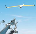
Project Marti will use a high-flying unmanned platform to collect data from a variety of low-flying unmanned aerial systems (UASs) such as this ScanEagle. Hovering high over the theater of operations, the system will collect sensor information and transmit it to users below.
An airborne networking system may soon provide warfighters with real-time battlefield data gathered from sensors and reconnaissance platforms across a theater of operations. A high-altitude unmanned aircraft serving as a flying information exchange will link to a constellation of low-altitude robot air vehicles, making this capability possible. Users will be able to access data from battlefield computers and ground terminals.
Named after Radio Marti, the ongoing effort to broadcast radio signals into
According to Dr. Jim Paunicka, Phantom Works’ principal investigator on Project Marti, the effort’s main goal is to address the information stovepipes associated with unmanned aerial system (UAS) operations. “In many instances today, if you’ve got an unmanned aircraft system collecting information, it [the data] has to go down to a specific vehicle’s groundstation and then hopefully get distributed to the people who need that information,” he says.
Instead of a point-to-point transmission from a UAS to a control station, Project Marti seeks to break up stovepipes by requiring every platform to collect information and to beam the data up a high-altitude platform referred to as an information broker. This platform collects information from the low-altitude UASs, stores it and makes it available to soldiers in the area. “It’s many-to-many,” Paunicka explains. “You could have many troops on the ground with the right kind of radio and maybe a Toughbook tactical display being able to subscribe to or query information that’s being collected by a multitude of airborne assets in the area.”
Paunicka notes that warfighters on the ground will not need multiple groundstations to communicate with UASs. With the Marti high-altitude information broker platform, soldiers will be able to access all of this information via a single channel. Because the system is designed to operate in an ad hoc fashion, a physical network is not needed to tie these various platforms together.
The high-altitude broker will be either a conventional large, high-endurance unmanned aircraft or a high-altitude blimp or airship. It will loiter over a battlefield, providing data to all of the forces below it. Because the broker is intended to operate at 60,000 to 70,000 feet, it will be able to cover a wide geographic area. “We’ve seen that you can get up to 400 miles of coverage without a fixed infrastructure in place,” says Patrick Stokes, Phantom Works manager for network-centric related programs.
Because the broker will be at a very high altitude, it will allow communications and data coverage for forces separated by high mountains or deep valleys that may obstruct most line-of-sight communications. Stokes notes that Project Marti’s information broker is more than just a radio or data relay. The platform will archive information from other UAV sensors, and troops on the ground will be able to subscribe to and query the collected data.
Launched in 2006, the program conducted its first full, major-milestone demonstration in January. The experiment used multiple information sources, including ground-based software clients representing low-altitude UAS platforms such as the Boeing ScanEagle. The sources simultaneously transmitted the data in a cursor-on-target format that permits accurate, tactical information to be passed along efficiently to multiple systems.
To rapidly provide ground forces with communications and data capabilities, Project Marti will use information management brokering techniques providing publish-and-subscribe capabilities across a region. The Boeing team also is developing an interface to install on the ScanEagle UAS that will enable the aircraft to link to the Global Information Grid (GIG). This capability will allow the aircraft to publish real-time imagery or other sensor data directly into the network.
The AFRL is designing a communications link in conjunction with Space Data Corporation,
Boeing is currently working with the manufacturer of ScanEagle to install the communications modifications. Paunicka explains that this is a relatively simple package. “We’re trying to craft an interface that is applicable for other UASs, not just ScanEagle. But we’ll have an interface that collects a wealth of information from the sensors aboard ScanEagle,” he says. This data is encoded into the cursor-on-target software format and transmitted to the high-flying processing platform.
ScanEagle’s communications package will be tested in early 2008. Paunicka notes that for this demonstration, the UAS will remain on the ground, but it will communicate with an airborne platform. This communications package also is envisioned for use on other UASs, such as the ScanEagle Compressed Carriage. “It’s something like a ScanEagle, but it can be launched. It has control surfaces that can be unfolded upon deployment, so it could be launched from a V-22 Osprey, a C-130 or maybe even from a tube fired from a submarine,” he says.
 |
| The goal of Project Marti is to provide mobile warfighters with real-time battlefield information without the need to establish a physical communications or data-sharing network. |
However, ScanEagle presents another challenge because it is not a large platform. Its limited size requires that any new avionics be designed to fit into a small space with limited power. “It would be a lot easier to add something like this to a Global Hawk or Predator [UASs],” shares Paunicka.
Project Marti also is using a second UAS, the lightweight Raven aircraft. This small, tactical platform represents the growing number of very small UASs used by
For the course of the ongoing demonstrations, the balloons used to loft the information broker have been tethered either to platforms or combat skysats, which are untethered high-altitude systems similar to weather balloons. The balloons are limited to six-pound payloads, which creates limitations in bandwidth, transmission times and ranges. For the purposes of the demonstrations, Boeing and AFRL scientists do not anticipate achieving the 400-mile radius envisioned for a larger platform. “With this balloon we’re constrained to a six-pound payload. With a HALE [high altitude long endurance] vehicle, we could be looking at 600 pounds of payload, which would make a much more robust communication network and give us the additional power to achieve the ranges that we want,” says Stokes.
Paunicka explains that the AFRL wanted to show that a high-altitude broker can eliminate any line-of-sight issues for communications. But for cost purposes the payload is kept below six pounds so as not to exceed the Federal Aviation Administration’s (FAA’s) bird strike limit. The low weight also allows researchers to launch balloons for tests without any need to coordinate with the FAA. The AFRL is refining the broker’s payload to meet the weight constraints. The unit will consist of an antenna, a radio, information management software, reference implementation software handling information management functions such as storage and support for publish-and-subscribe functions. Part of ScanEagle’s payload also is used for publishing exploitable information up to the near-space broker. Likewise, the information management software is hosted on ground troops’ laptop computers.
The ground-based features of the system will allow users to perform functions such as drawing a box on a map and subscribing to all the UAS sensor data in that box. The system will enable users to conserve bandwidth by subscribing only to the sensors they need. The high-altitude broker will handle the subscription request, mediate the data coming into the broker and send down only what the troops on the ground ask for, notes Paunicka. The AFRL-developed information management functions also will mediate any issues involving bandwidth use. “With the publish-and-subscribe mechanism, we send only the information that folks ask for,” he says.
The program has several operational tests scheduled for late 2007 and early 2008. These evaluations will be followed by the installation of avionics systems into ScanEagle, allowing it to participate in a realistic warfighting scenario. Paunicka notes that the program may partner with the U.S. Army or U.S. Marine Corps to develop and participate in a combat scenario. However, Stokes cautions that additional work is required to refine the technology before the program can move to a full development and procurement effort.
Web Resources
Air Force Research Laboratory Information Directorate: www.hanscom.af.mil/afrl%5Fif
Boeing Phantom Works: www.boeing.com/phantom
Space Data Corporation: www.spacedata.net