Coast Guard Seeks Maritime Omniscience
 |
| An HH-65 Dolphin stationed at Air Station Houston examines a ship inbound for the Houston Ship Channel. Patrolling from the air is one way the U.S. Coast Guard is incresing martime domain awareness (MDA). |
Top-down intelligence will boost security.
The U.S. Coast Guard is going on the offensive with a transformational initiative that represents a fundamental shift in how the service operates. Rather than serving primarily in a response mode, the service is taking a proactive approach to understanding the global maritime space so it can assess any vessel that could affect the safety, security, economy or environment of the United States. To accomplish this task, the Coast Guard will be relying on technologies that help track watercraft, distinguish normal activity from potential threats and provide this information to the people and organizations that need it.
The concept is called maritime domain awareness (MDA), and it turns the conventional intelligence-gathering approach on its head. Traditionally, one or two pieces of information are identified about a vessel, person or target, then Coast Guard personnel track it down. Although this bottom-up technique still will be employed, the MDA approach expands intelligence-gathering by looking at all vessels, their crews and other related personnel and sorting through this information using intelligent agents and other data processing tools to find targets of interest.
Capt. Dana Goward, USCG (Ret.), chief of programs and architecture, MDA, U.S. Coast Guard, Fort McNair, Washington, D.C., admits that this is a daunting task and comes down to a sorting issue fairly quickly. “But hopefully, between the two approaches—the bottom-up and the top-down—we’ll be able to shake most of the bad guys out of the system and identify who they are and then focus on them and prevent attacks,” he says.
To expand from what Capt. Goward calls the “firehouse mode” of responding to incidents and being able to anticipate threats, the Coast Guard must know and understand vessels and activity in the entire maritime domain. Accomplishing this requires the service to have information about nearly every type of craft. “We’d like to be able to look at essentially anything that floats. That’s a stretch as a goal; we’ll never get there. But in a very real sense, there are some places and some situations where we are going to worry about kayaks and inner tubes. The Florida straits come to mind. In the vicinity of a nuclear power plant or an aircraft carrier, we’ll worry about kayaks and inner tubes. We’ve got to know about them,” the captain relates.
Tracking this plethora of vessels begins with sorting them into two categories: cooperating and noncooperating vessel owners. Cooperating owners carry a transponder onboard their craft and report their position, course and speed or help the Coast Guard know their location and intentions in some other way. Noncooperating watercraft owners may not be engaged in illegal or surreptitious activities, but they are not overtly providing the Coast Guard with tracking information. As a result, the service must find proactive methods to determine their activity.
A number of approaches are being employed to track vessels. The Coast Guard is working with the International Maritime Organization (IMO) to create worldwide standards for tracking commercial craft. It also is developing an automatic identification system (AIS) capability and building a shore-side AIS network.
The AIS capability includes installing AIS receivers on National Oceanic and Atmospheric Administration buoys as well as on offshore oil and gas platforms in the Gulf of Mexico to extend the AIS’ reach. “There are thousands of lit platforms out there, not including well heads. We have a contract to put AIS receivers out there, and we think that we’ll get a couple hundred miles of visibility on each receiver. So, we’re going to be able to cover the Gulf of Mexico pretty well,” Capt. Goward explains.
In addition to these receivers, the Coast Guard launched a satellite late last year to examine the feasibility of picking up signals on the high seas. Although signal density near shores may be too great to be distinguished by the satellite, it could help monitor the location of vessels in open waters, the captain allows.
“In terms of the AIS project, we have a nationwide acquisition project to build the whole system, but these projects are accelerated projects in advance of the major effort just so we can get more capability out there,” he relates.
The Coast Guard also has installed AIS capabilities in its vessel traffic system (VTS) ports. The system includes a combination of cameras, radars, AIS technology, radios and watch standers that help in busy ports so vessels do not run into each other or fixed objects. Additionally, the service is contracting with the Maritime Exchange of Alaska, a nonprofit organization that serves the Alaska maritime community, to install AIS receivers on vessels.
To enhance tracking cooperative vessels, Capt. Goward notes that a system is in place so that transporters of certain dangerous cargo on barges traveling on inland rivers can report their positions to the Coast Guard. Information about these barges is put into the Coast Guard’s common operational picture (COP).
“In terms of the noncooperating methods of tracking, quite frankly, we’re not nearly as far along. Obviously, we have radar in some of the VTS ports. We have a testbed in Miami where we’re looking at commercial off-the-shelf technologies and developing additional technologies for port and coastal surveillance. There is a government-developed and -owned command and control platform that all of the sensors in Miami feed into, and this information is displayed on one screen. It also provides the capability to link that command and control node to the overall national COP,” the captain states.
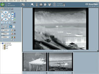 |
| An infrared camera system installed at the port of Valdez in Alaska shows a vessel transiting through Prince William Sound. As part of MDA, the Coast Guard plans to increase its use of technology to track both cooperating and noncooperating vessels. |
In addition, the Coast Guard is working with the National Security Agency and the U.S. Defense Department to purchase what the captain calls the big-ticket items. “The huge antenna arrays that look out 1,500 miles, the relocatable over-the-horizon radar, the high frequency surface wave radar generally would be budget busters for us. We’re trying to evaluate what’s good and then go to U.S. Northern Command and the Defense Department and others to say, ‘This is what we need for our joint efforts,’” he says.
By far, tracking noncooperating vessels poses the biggest challenge, the captain admits. The great majority of these are pleasure craft that are either documented with the Coast Guard or have a pleasure craft registration number that is issued through individual states. The service is working with the states to establish a standard query method because currently more than 50 different databases reside on computer systems that are configured in various ways and at a multitude of levels of automation.
“We’re trying to take advantage of extensible markup language and other kinds of query tools such that at the very least an enforcement officer can type the pleasure craft registration number into a handheld device or his base station can enter the information into a computer and get a fairly quick return of whatever data the host state has on the vessel,” Capt. Goward relates. This capability would allow enforcement officers to know if they should examine a vessel more closely, he adds.
The captain shares that there has been discussion about embedding state decals with a radio frequency identification chip either the next time they are issued or on a regular cycle. This would allow the Coast Guard to identify a watercraft automatically whenever it passes a buoy that hosts a receiver. “Or maybe we want to increase the carrying requirements for AIS, provided we can get a less expensive Class B AIS on the market so that a lot of vessels, especially those on international voyages, are automatically identified and tracked,” the captain says. There has been some resistance to adopting these ideas, he adds, because of cost and privacy concerns.
The Coast Guard also is examining other tracking techniques. For example, in Alaska an experiment was conducted recently that involved a Predator unmanned aerial vehicle equipped with an AIS receiver. In addition, the service explored using unmanned blimps, known as high-altitude long-endurance, or HALE, vehicles that can stay in the air for months and be employed the same way the Predator would be used. “A lot of this stuff is in the proposal or design stage, but some of it is actually being played with in the field,” Capt. Goward shares.
Sifting through all the data and vessels is the biggest challenge, the captain notes. Eliminating the first, second and third levels of vessels—those that most obviously do not pose a threat—has to be done through automatic data processing using rules to set aside vessels that are engaged in normal activity. A preponderance of the sorting will be done this way, he says. In addition, intelligence agencies will be generating information independently, so Coast Guard personnel will be able to access a much richer database to compare and contrast the information they receive from sources such as the AIS.
Another important element of MDA is enabling field operators to make intelligent on-the-spot decisions about their own area of responsibility. “One of our big efforts is to take all the vessel targets and link those with as much information as possible across any number of classified and unclassified databases to have a consolidated piece of information in our COP. Using the COP, a person could click on an icon for that vessel and get several folders that are immediately available with information not just about the crew, but also maybe five or six degrees of association for each crew member; not just about the cargo, but also where the cargo has been; not just about the ship, but also who owns the ship, its history and where it’s been. That’s the idea, so that you have as much information made available to as many people as is appropriate across as broad a spectrum as you can,” the captain explains.
The COP already is growing by leaps and bounds on a daily basis, he adds. Linking vessel tracks and information to Coast Guard databases so that the data is displayed automatically is a capability that will be available in the next three to four months, Capt. Goward notes.
Intelligence gathering and information sharing are the first two elements of MDA, but the captain explains that the effort has even more lofty goals. The Coast Guard wants to be able to look at patterns of activity over time and develop the tools to identify anomalies in behavior automatically. “Perhaps one vessel has veered off the route it has taken for the past five years and it’s been diverted to a new purpose that could be quite innocent—a conscious decision on the part of the shipping company—or it could have just been hijacked. This is a very simple example, but the ability to do much more complex analysis automatically is there as well,” he warrants.
The service’s work with the IMO currently focuses on reaching a consensus about a global tracking capability. Vessel owners and flag states should be able to know with some accuracy the location of their craft most of the time, and port states should have some access to this information for ships that are bound to their ports, the captain explains. However, the issue that has been receiving the most attention relates to coastal states. The question is how much access coastal states should have to this information about vessels that may be just innocently passing through their waters.
“Should we have access to information about vessels that are within X number of miles of our shore but have no intention of coming here? At some point one could say, ‘Yes, probably so,’ because all they have to do is make a right-hand turn and then ignite themselves, and it’s a bad thing. The question is this: What is that point? You could say 2,000 nautical miles because if you’re asking for folks that are innocently inbound to give you 96 hours to think about them, then why shouldn’t folks that are passing by meet the same criteria? So the discussion is ongoing,” Capt. Goward says.
Challenges may abound in making the MDA concept a reality, but the availability of a range of effective technologies is not among them. However, the captain relates that identifying and implementing the appropriate technologies is one hurdle that must be overcome. In addition, he says that prioritizing the various projects within MDA and then priori tizing the tasks within projects are difficult and so is advocating for them throughout the government.
“From a technical perspective, there will be technical challenges down the pike, but right now there are probably sufficient technologies available to do the things that we have the political will to actually do. At this point, the challenges are prioritization and policy issues and how those fit in with different budget priorities.
“We would have to spend a lot of money and a lot of time implementing technologies that are available right now before we got down the list to where we would feel compelled to develop something new, before we spent the next dollar intelligently,” Capt. Goward says.
Although the technologies are available, industry still has some very important work to do, he adds. Developing less expensive tracking and reporting methodologies would be useful so more vessel owners would be likely to use them. The goal, Capt. Goward says, is to find AIS technologies that are less than $250. In addition, designing less expensive, lighter technologies, such as radar, to track noncooperating vessels would help improve MDA.
In terms of software to manage the huge amount of data that the MDA program will generate, the captain believes solutions already exist. “There is a wealth of tools out there for sorting through the information. Our big challenge is deciding which system to go with and getting the budget to pay for it,” he says.
Web Resources
U.S. Coast Guard: www.uscg.mil
The Subcommittee on Coast Guard and Maritime Transportation Hearing on Maritime Domain Awareness: www.house.gov/transportation/cgmt/10-06-04/10-06-04memo.html
Maritime Domain Awareness Industry Groups: www.whisprwave.com/links/industry-groups-links.html
The Maritime Domain Awareness Newsletter: http://members.cox.net/flotilla4- 10/Flotilla%204-10%20Files/Maritime%20Domain%20Awareness.htm


Comments