Disaster Management Program Offers Information at the Ready
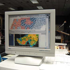 |
| Disaster Management Interoperability Services (DMIS) software can provide the emergency management community with up-to-date weather reports and imported flood-plain maps to reduce the loss of life and property in natural disasters. |
Federal agencies responsible for citizen safety are utilizing the latest in technology to improve delivery of disaster assistance information and services to citizens and the emergency responder community. As Americans began using the Internet for everything from managing bank accounts to buying groceries, some U.S. government agencies realized that they were not meeting the needs of their computer-savvy constituents. Although citizens could find a plethora of information on the Web, critical government-held information that could save lives and property after a natural or man-made disaster was lacking.
Collectively known as the Disaster Management Program, the initiative includes the creation of the DisasterHelp.gov Web portal and makes available Disaster Management Interoperability Services software used to consolidate disaster information and provide the tools for first responders to communicate and citizens to find the information they need.
The program is one of the president’s 24 e-government initiatives announced in 2002. The DisasterHelp.gov portal serves five overlapping audiences—local, state and tribal governments; individual citizens; private sector businesses; nongovernmental organizations; and federal agencies—and is designed for use by the public and the emergency management community. The public site primarily serves private citizens and businesses. It features disaster-related information offered by a large number of government and nongovernment organizations. The site is organized according to disaster type to facilitate navigation. Each disaster section includes links to other government Web sites, press releases about current disasters, information about damage prevention and recovery efforts, and relief services and assistance programs that citizens can apply for online.
Chip Hines, program manager, disaster management, for both the Federal Emergency Management Agency (FEMA) and the U.S. Department of Homeland Security (DHS), Washington, D.C., describes how the site is adapting to meet citizens’ needs. “During discussions with the Department of Agriculture, for example, we identified that, although food is not a disaster, there can be food-related emergencies that require the government to relay information to the public,” he explains. As a result, the food section of the DisasterHelp.gov site includes food recall announcements, mad cow disease information, a list of foods to stock in case of a disaster and instructions on water storage and treatment in disaster situations.
Some areas still need improvement, Hines says. He would like the site to be more useful at the state and local levels and more personalized for each citizen or community. “We would like to offer the citizen the ability to type in the zip code and be provided with information on the emergency management contacts in the area,” he says. “In addition, citizens would be able to learn whether their area is susceptible to any hazards.”
For the approximately 13,000 verified users from the emergency management community, the portal offers a variety of online tools that enable them to collaborate, disseminate information, provide better situational awareness and better prepare for emergencies. Verified emergency management communities can create and manage their own knowledge centers in the portal’s Enterprise Collaboration Center to share files quickly and easily with other authorized users.
The knowledge centers can educate other emergency response groups as well as help develop best practices for emergency response. For example, the DHS Geospatial Preparedness Team conducted a series of five regional emergency management workshops and wanted to share documents with attendees within each workshop and solicit feedback. Attendees also would be allowed to post their own files to share with each other and access the documents produced from all five workshops.
To meet these needs, the team created a knowledge center for each workshop in the portal’s Enterprise Collaboration Center. To ensure the integrity of the content posted to each center, only conference attendees could post documents. In addition, all posted documents had to be approved by one of the workshop facilitators, before being published on the Web in the knowledge center.
Hines notes that the emergency management community is increasing its use of the knowledge centers. Currently, there are more than 2,000 independently run knowledge centers. However, he believes that his main task is still to get the word out that this site is ready and available at no cost to emergency managers and first responders.
Another capability on the portal, called the readiness assessment tool, allows geographically dispersed organizations to report their status and provide up-to-date situational awareness. FEMA’s Urban Search and Rescue task forces across the country use it to keep track of team readiness. Before this tool was available, these task forces reported their status by calling in to FEMA headquarters, where the information was simply written on a grease board. Individual task forces were unaware of each other’s status and had to call headquarters for the information. By the time they received it, the data could be outdated.
Portal users can update readiness information from any location with Internet access and view the status of all other task forces on one screen. In addition, the tool enables users to manage the time-sensitive data better by sending them reminders to update their information.
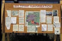
One example of how the portal can help first responders and the community is its use during the wildfires in Southern California. The site enabled air support responders to upload pictures of the fire and additional data continuously to a secure portion of the site and share them with people engaged in the response effort. To those without access privileges such as citizens, daily updates were made to the home page that highlighted announcements and available resources from the National Fire Information Center, FEMA and other partner organizations.
Other features of the portal include instant messaging between verified users, a community page to display external Web pages and alerts, and the ability to personalize a Web page and calendar.
 |
 |
| Using the portal and the DMIS software can revolutionize emergency management information sharing. Vital information would be a few clicks away on a computer instead of posted on isolated bulletin boards and wall charts. |
The DMIS tool set enables authorized users to send an incident alert to other organizations, display incidents as icons on a national map, send messages and respond to specific requests for resources or assistance as well as track and share situational awareness of an incident.
Hines recounts an event in Johnstown, Pennsylvania, where an unknown substance—later determined to be tear gas—was spilled. Victims reported burning in the eyes and other symptoms. The area fire chief logged onto DMIS and updated six area hospitals continuously on the victims’ symptoms. Vital data was quickly shared without anyone having to make multiple telephone calls. Hines reports that the hospitals were made aware of all the victims’ conditions in advance, and the staff was prepared to treat them upon arrival at the medical facilities. The incident was under control in less than two hours. Hines says that by helping the first responder do his or her job better, the DMIS is ultimately helping the citizen and protecting life and property.
According to Tom Lockwood, deputy director of homeland security, State of Maryland, the DMIS software serves as an architectural framework on which first responders can build. “It provides a minimum set of capabilities that allows emergency responder communities to integrate other tools.”
The software was first installed in Laurel, Maryland, but it will be incorporated statewide. “It was a great location for us to start to test the interoperability capabilities of the program,” Lockwood says. “Interstate 95 runs directly through Laurel, and the north/south railroads run through it as well, which makes it possible for different agencies to be involved in one incident,” he says. “If you have a car accident, the police are notified, and they take care of the situation. But if that accident involves a tanker truck carrying hazardous materials, the response would expand to include more people from state and local agencies. Telephones alone could not handle the amount of information that would need to be communicated.”
The DMIS not only provides the tools to communicate during an incident, but also helps communities prepare for disasters. During Hurricane Isabel in October 2003, for example, emergency personnel from the state of Maryland recognized the effects that the hurricane might have on a dam that was near two roads. “Within 10 to 15 minutes we had the information to the people in that area, and the problem was resolved.”
Hines reports a similar story. Prior to Hurricane Isabel’s arrival in the Maryland area, responders imported flood-plain maps using the DMIS backbone and realized that two apartment communities would be affected by dangerous flooding. They had the time to prepare to evacuate both buildings. “This is an example of something they were able to do ahead of time, rather than react to the problems that came,” Hines says.
The software uses the Internet but is not browser-based. If connectivity is lost, responders can continue to work, and the information will be synchronized once the connection is re-established. The dial-up access system provides operators with the ability to connect to the DMIS over low-bandwidth connections, approximately 30 to 40 kilobits. Although the software currently is free, in 2005 it will cost $330 per year.
Hines also is working with a consortium of approximately 60 vendors to promote the research, development and deployment of emergency interoperability standards among different systems that use Web tools. These vendors all have an interest in the emergency management community and are building XML standards for data exchange. The common alerting protocol is the first one the consortium helped develop. “When someone wants to generate an alert,” Hines explains, “using this protocol, the alert can be received by anyone following the standards for the system. Using the DMIS interoperability backbone, completely separate commercial emergency management products can exchange this alert.” The importance of the consortium is that eventually it will not matter what particular software is used by an emergency management organization. The DMIS will be able to exchange critical information through all other systems.
While technological advances are driving the disaster management programs, Lockwood notes that it is the resulting cultural change in communications that makes this initiative so important. “The system creates a framework for nontraditional organizations to work together and share information as well as build support and information from the bottom up,” he maintains.
The DMIS and the portal continue to be updated and expanded across the country. The second version of the software was released in February 2004, and currently more than 500 groups in 49 states use the DMIS. Hines also expects to have a full agreement with the consortium by this summer on how to develop interoperability. Although the portal was originally managed by FEMA, it moved under the DHS structure this spring. Hines is looking forward to expanding the site’s capabilities across all DHS emergency management measures.


Comments