GPS Helps First Responders Rule the Road
First responders can’t always use the same apps the general public depends on to get to their destination by the fastest route. Commercial apps may not factor in delays such as weather events, traffic accidents or the size and weight of their vehicles.
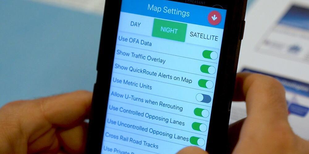
To address first responders’ special needs, the Department of Homeland Security Science and Technology Directorate (S&T) and partner Azimuth1 LLC are developing QuickRoute, an app that uses GPS and routing data to provide turn-by-turn directions. Not only will the app warn responders of hazards along the route but also leverage additional data streams that will offer emergency personnel greater flexibility when time is of the essence.
QuickRoute takes into account the capabilities of different vehicle types such as required turn radius or bridge and tunnel clearance as well as their unique ability to use lights and sirens to clear paths and avoid signals. Other data sources, including weather patterns, traffic and transit schedules, and local jurisdiction rules such as right-of-way and private access roads, are also factored in, giving responders the quickest and safest route to the scene.
“There’s a tremendous need for an application like QuickRoute,” says Justin Green, battalion chief, special operations, Fire and Rescue, Loudoun County, Virginia. “It sounds very simple to go from point A to point B, but there are many factors that impact a first responder’s route. What we’re focusing on here is a lot of that information that we don’t have ready access to, such as traffic conditions, roadwork projects, weather impacts such as flooding or snow, or accidents that other agencies may report that we don’t hear about.”
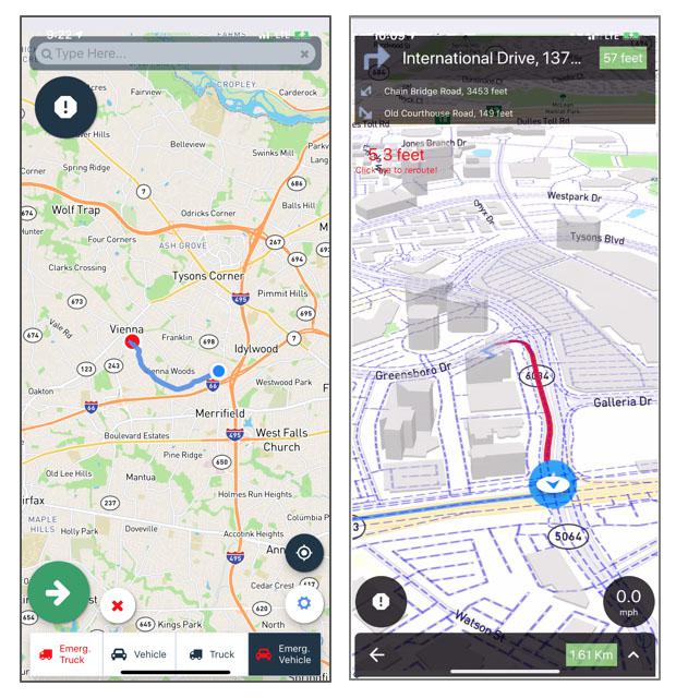
In April 2019, S&T and Azimuth1 field-tested QuickRoute with first responders and transportation stakeholders at a DHS federal law enforcement training facility in Maryland. The test plan, designed by S&T’s National Urban Security Technology Laboratory, had participants evaluate QuickRoute in several staged response scenarios, including medical emergencies, accident response and fire calls. Hazards included weather events and roadway challenges placed along the routes.
During the trial, responders were tasked with using the app to navigate through simulated lane closures, drive the wrong way down a one-way road, cross over road dividers and enter a roadway via an exit ramp. Along each route, the app sent alerts about road or weather conditions that could hamper a timely response and suggested alternate routes to more immediately direct their specific vehicles to the simulated emergency scenes.
Evaluators provided valuable feedback about additional app features, integration with computer-aided dispatch systems, and alerts and notifications that Azimuth1 will soon integrate.
The QuickRoute team continues to refine the app’s back-end system, which features after-action reporting functions that display paths taken and other key routing data that agencies can use to calculate time saved and advantages and disadvantages of particular routes. Responders will be able to compare routes QuickRoute calculated with the routes civilians regularly take.
A report of the findings from the April 2019 QuickRoute operational field assessment will be posted to the S&T website, and the QuickRoute system itself—the app and a desktop version—will be available for purchase during the second quarter of 2020.


Comment
The danger being overlooked
The danger being overlooked with articles like this one is twofold: what happens if our GPS is knocked out? Chinese internal intelligence directives preach 'only one' global navigational system (theirs, Beidou); and China and its military partner India have both demonstrated recent showcase destruction of GPS satellites. What's your back-up system? Celestial? Pulsar, what? Secondly, what happens if your responders fall victim to gps spoofing? The tactic Iran used, compliments of China again, to trick the UK commercial vessel off-course into Iranian waters this month. Russia has 'tested' some 5,000 GPS spoofs against commercial shipping already this year. Flexing its muscles. And Israeli Airport Authorities in July warned that commercial jet pilots (!) were unsafe landing and taking off to to GPS interference from Iran and other terror groups or hostile nations.
So our country needs to take a very solid, fast look at alternatives. Because we may all wake up one day - and ambulances have no guidance or first responders are steered off-course, or into a flood or wildfire. Everyone is so enamored with multi-national cooperation, they are ignoring really huge red flags, like such incidents. I have warned since 2015 that the US and NATO need to quickly develop alternative navigational systems ... but it's not yet 'sinking in." We still welcome China with open arms, to our global GPS and Nasa navigational conferences, with offices in Reston VA, and representation from every leading federal agency: but China is the main culprit. China gave Iran the satellite network and tools and knowledge to capture the UK ship. And the SAM missile to shoot down the US Navy drone. China is even MORE reliant on GPS than the US or West ... but China also uses Beidou for two-way listening in. A third danger we've not yet adjusted to, or even, wish to listen to. We can't live in Disneyland forever. Our nice neighbors or bankers or H-1b visas working in the next cubicle, are the same nations that attacked us in Sept 11; that are forcing US and UK troops back into Afghanistan to fight the Taliban again; and that spends 75% of its GDP on tactical military build-up. (China). Russia pales in comparison to China. Ironically, Loudon County, cited in this article, is also home to one of China's largest POP and satellite ground station infrastructure locations in the US. WHY hasn't Loudon raised this issue before? Because whatever supports Chinese navigation over the US - Beidou, Yulong - also gives them the ability to fire and steer weapons against us, and for their 'children," like Iran, to declare war on us. Or send terrorists against us. China has 4 secure data centres in Sterling, a few blocks from the Loudon Sheriff's office. That won't seem so nice if one day all of Virginia first responders are steered into oblivion or an ambush somewhere. Or into crashing into one another.
Comments