Health Experts Prepare For Regional Crises
 |
The dominent feature of the U.S. Department of Health and Human Services command center is a wall of 10 projection screens that can present any combination of 10 different information dislays or a single large image. |
The U.S. Department of Health and Human Services has prepared for a serious health event—including a biological attack—anywhere in the United States by building a multimedia command center in its Washington, D.C., headquarters. This facility serves both to present all the necessary information to a decision maker and to establish vital communications links to emergency responders even during a devastating public health event such as a pandemic or a bioterrorism event.
The department comprises a host of health-oriented organizations, including the Centers for Disease Control and Prevention, the National Institutes of Health and the Food and Drug Administration. These and many other organizations all fall under the direct supervision of the secretary of Health and Human Services (HHS), and the command center serves as his central point of information. The secretary is the focal person in the center—all of the briefing material for a particular incident is available at his desk, and he is able to conduct videoconferencing from that station.
This command center also serves to help department officials remain informed and make key decisions during a range of potential crises or events that may require HHS involvement. During last year’s Hurricane Isabel, for example, department officials in the command center used the same hurricane models employed by the National Oceanic and Atmospheric Administration. However, instead of focusing just on storm tracks, the department used the models to project how many people might require emergency assistance during and after the storm.
Most of the personnel staffing the center are public health services officers. Some positions, such as meteorology and geospatial information systems, represent full-time staffed disciplines. In many cases, staffers are multidisciplinary, including dual-master’s personnel.
While a small crew works during off hours late at night, the center can accommodate 26 people at individual workstations when preparedness or homeland security threat levels rise. And, the composition of these staffers varies with the situation. The crew during a hurricane would be vastly different in specialization from that required to cover a potential biohazard event, for example.
Not all of these personnel are department officials. Federal partner agencies and departments may be represented, as may nongovernmental organizations such as the American Association of Blood Banks. These personnel serve as liaisons between their groups and the department, and they are interactive in the center. All the technologies necessary for these representatives to communicate with their organizations are in place at their stations.
During last year’s Severe Acute Respiratory Syndrome (SARS) outbreak, the Federal Aviation Administration provided data that helped predict the flow of the disease from the overseas locations of outbreaks. This flight data enabled the center to construct 24-, 48- and 72-hour prediction models of how the disease might migrate via air travelers. Experts were able to tailor surveillance of targeted entry points to detect whether the virus was entering the United States aboard an infected passenger.
Incident management software helps the department gather information in the same manner as the U.S. departments of Defense, Energy and Veterans Affairs. The first three days of Hurricane Isabel generated the equivalent of more than 6,600 pages of text, according to Dean A. Ross, director of the command center.
Geospatial information system (GIS) data is a vital element of the center’s information, explains Satoshi Manabe, a program analyst who specializes in telecommunications for HHS. Having GIS information improves the ability of officials to understand an incident that is emerging or underway.
The center was built last year in only 59 days. The HHS secretary’s offices are just a few steps away. Ross notes that the center was designed with substantial input from personnel with actual federal disaster experience.
The room is dominated by two walls featuring giant video displays. On one side, four large plasma-screen monitors are tuned to commercial television stations. The center can access four transponder channels to provide real-time imagery from U.S., European, Asian and Arabic satellite television networks. The screens usually are tuned to 24-hour news channels.
An adjacent wall features 10 projector screens abutting each other to form a giant video display 8,000 pixels wide by 2,400 pixels high. Operators can present a single image across all of the screens, or they can provide different displays of information on each individual screen. The projector-based system does not suffer the burn-in common to cathode-ray tubes or plasma screens, so it can display static images for long periods of time without any ill effects. One wall-length view is a global image tied to the center’s custom time clock. This image shows the world as it would appear at a particular time, with a shadow illustrating the portion of the globe in night.
Other times, different types of data are displayed on the individual screens. During an incident, these 10 screens can display various types of active data or predictive information. Four of the screens together, for example, might display a map of an incident location. Another screen might show a statistical report or a time graph, while a companion screen shows a weather map for that location displaying climate conditions or a depiction of the wind-borne spread of an airborne substance. Yet another screen might list available resources. Other potential displays include a global or regional map of a disease spread, national or regional weather forecasts, contamination patterns, icon-driven imagery of available local resources or even a map of forest fire activity.
The department purchased existing technology for the center, relates Steve Caesar, program analyst at the center. Caesar, a former firefighter who also serves as staff meteorologist, notes that very little software was beta technology. Except for some software written for the center, virtually all of the technology was time-tested in a disaster.
The September 11, 2001, attacks and the 2002 Winter Olympics in Salt Lake City were the two main driving forces for technology acquisition, he continues. Any technologies that the department needed but did not have at those events were added to the center’s acquisition list. For example, the nation’s entire communications infrastructure was overwhelmed on September 11, so the center was designed around the concept of ensured emergency communications throughout the country.
The center uses an Internet protocol (IP) telephone system that allows anyone with an IP address to be connected with a local extension anywhere in the world. Headsets enable each person staffing the center to have an individual connection to a call or a videoconference. The individual also can use the IP telephone headset to listen to one of the television broadcasts displayed on the plasma monitors.
Redundancy is the byword for the center’s external communications. Its telephone system goes into the public switched telephone network. But, in addition, it has interfaces going out into two separate satellite telephone networks. These commercial networks operate on two different satellite systems, so a failure on one will not disable the other.
Satellite IP backs up the landline IP telephony. This link also provides an alternate route for incoming IP connectivity with HHS headquarters during an event.
Maintaining 100-percent uptime for the communications network is a major challenge, Caesar says. The primary, secondary and tertiary systems in the command center’s data network have kept internal operations running. However, relying on connectivity from other Internet service providers creates problems. Even though the center is obtaining data connectivity from the headquarters building’s enterprise network, the satellite connectivity comes from an outside provider.
Along with connectivity to the Web, computers are a major element in the continued operation of the center. During last year’s virus worm onslaught, the HHS headquarters building virtually shut down, officials relate. Operators could not do their work with their computers stricken. In fact, the center downloaded its own security patch to the rest of the building to help the department’s information systems return to operation.
The center has radios that operate in the lower very high frequency (VHF), public service VHF, ultrahigh frequency and 800 megahertz bands. These radios permit it to communicate with a range of emergency responders. Another system permits it to connect different radio systems to create a common communications network. This network even can be tied into a telephone system so that a user can operate remotely using a cellular telephone. These networking capabilities can be especially useful for connecting diverse federal government organizations.
For the center to communicate with local authorities on their systems, it will require an interoperability hookup through the HHS mobile vehicle (see below). The center would establish a link to that vehicle, which in turn would patch through the local frequencies to the headquarters. The HHS command center in headquarters can interoperate directly with municipal authorities that have well-equipped command centers of their own with interoperability technologies.
Manabe relates that engineers are working to develop a system that permits any user with a radio and a voice-over-IP interface to access the command center system. This would enable the department to connect the center with a local public service radio network during a regional incident.
Some command center personnel—among them Manabe, Caesar and Ross—are Ham radio operators. They are working to find a way to tie the amateur radio network into the command center through an Internet remote base. The concept is for an official to control a radio through IP, which would allow the center to link with an incident area when regular radio communications are not effective.
The command center features a 20-terabyte storage area network (SAN). Information on this SAN is replicated to a distant secondary site in real time. So, if a catastrophic event—a rampaging computer virus or even the destruction of HHS headquarters—knocks out the command center SAN, the information necessary for HHS to continue its mission remains available. Caesar relates that numerous continuation-of-operations sites exist to allow officials to tap into the command center SAN.
Ross observes that the department is building high-resolution—six inches per pixel—GIS imagery of various cities. This imagery will include oblique perspectives that will allow analysts to estimate the heights of buildings or debris piles. Imaging just 20 cities will require 7 terabytes of data, he observes.
Moving data from this database requires bandwidth. The center features OC-3 (155.52 megabits per second) connectivity with the core database.
Ross notes that the department has created a Web interface so that U.S. hospitals can enter logistical data on a daily basis. This data would encompass the availability of items such as decontamination facilities or isolation rooms, for example. During an incident, HHS experts can combine that data with GIS data to provide a clearer picture of emergency response options.
Commercial E-Team software enables collaboration among HHS agencies. These organizations can share—obtain and provide—information with the command center using this Web-based program. Vital information such as critical response assets can be attached to an incident report.
The department has shared the plans for its command center with other U.S. government organizations. Officials also have worked with their counterparts in other agencies on individual technologies and systems.
This cooperative effort does not stop at the U.S. border, however. Ross notes that the HHS center has been working with the World Health Organization (WHO) in Geneva, Switzerland, on the development of WHO’s own command center. This center, which went on-line last month and will reach full operational status in May, shares the same architecture as the HHS command center. The WHO facility will feature a public health surveillance system that can monitor health issues in its 193 member nations.
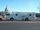
Vehicle Provides Mobile Command
In the absence of a functioning Washington, D.C., command center—or when a local command post is desired—officials from the U.S. Department of Health and Human Services can turn to a fully equipped bus to serve crisis management needs. Known as the mobile command post, or MCP, the vehicle employs virtually the same technology found in the headquarters command center. All of the incident command areas inherent in the headquarters facility are represented in the MCP. Separate stations are designed for administration, communications, operations control and logistics. Even the forward area of the bus can be used as a workstation. Operators can wear headsets to communicate either with each other or with outside authorities. The system permits communication with other organizations’ radio systems without requiring a separate microphone for each network. The communications section features three high-frequency radios that can be tuned to different frequencies for interoperability. One can establish secure encrypted links. The system also has two very high frequency 99-channel radios and six ultrahigh frequency 99-channel radios. Other radios include 800-megahertz and trunk systems units. A separate device permits operators to connect all of these radios for full interoperability. For example, users arriving in one municipality can communicate with all of the diverse elements of that city’s emergency responders and government authorities. The MCP also enables operators to connect these authorities with each other when they operate on different frequencies. This section has its own computer and includes monitoring devices that can allow users to garner information as the bus rolls into a crisis area. A control rack handles much of the MCP’s systems. It includes a control system for an exterior-mounted camera that can provide 360-degree coverage of the view outside of the vehicle. Touchscreens enable operators to control video feeds to other locations. Broadcasts from a weather alert radio, normally in a standby mode, can be fed into a radio frequency to keep all the listeners informed on weather developments, which could be vitally important in dealing with the dispersal of an airborne chemical or biological hazard. The bus features a 110-watt repeater and a 52-foot mast that provides an eight-mile range for communications. A wireless local area network capability allows responders to establish Internet protocol (IP) telephony with people inside of a nearby building. Satellite telephony links include an Iridium system with an external antenna and a dataflow channel. Another satellite system, which is IP-based, allows 2-megabits-per-second satellite Internet and telephony. Multiple power sources allow the MCP to operate independently or tap into an existing power flow. An onboard generator can power the MCP for four days on a full tank of fuel. And, the bus could just pull up to a city light pole and tap into a line ranging from 110 volts to 480 volts. The MCP’s computers and servers have battery backup. The rear of the vehicle features a small conference area that can double as operators’ stations. A large plasma screen allows personnel to view any number of stations, both national and local, on a satellite television downlink. Steve Caesar, program analyst at the center, relates that the vehicle originally was established piecemeal. Then, a comprehensive renovation replaced many systems and addressed structural characteristics that, in some cases, caused systems to clash with others. In one example, the original telescoping mast was attached to the exterior panel of the bus and its bumper—not to the vehicle’s framework. High winds could have twisted it or even detached it. That drawback was rectified in the renovation. For shipping across long distances, the vehicle can be transported by air on a U.S. Air Force C-5 transport aircraft. However, smaller aircraft—even the fairly large C-17—cannot easily carry the MCP. So, the Department of Health and Human Services is working on two even smaller command vehicles. They would be versions of a high-mobility, multipurpose wheeled vehicle (HMMWV) or a sport utility vehicle (SUV) that would carry the necessary electronics for emergency response connectivity. This HMMWV/SUV-based command center would fit aboard a C-130 aircraft. However, it would not feature the physical workstations that line the inside of the MCP. Instead, it would serve as electronic linkage for a temporary command center established inside of a nearby building. The philosophy is to employ a specialized electronics vehicle that would provide the technological infrastructure for creating a command center in a local building equipped with tables and chairs for workstations. |


Comments