Data on Demand
 |
| The multisensor aerospace-ground joint intelligence, surveillance and reconnaissance (ISR) interoperability coalition (MAJIIC) is a prototype capability designed to provide warfighters with time-sensitive intelligence data. By querying the system, users can request imagery and data for specific areas of the battlefield. MAJIIC’s Web-based applications also permit soldiers to task surveillance platforms and sensors. |
A prototype information management and communications technology soon will provide warfighters with near-real-time intelligence. The network-based system collects imagery, video and other data from airborne and ground-based sensors and stores it in specialized servers. Commanders can then access this raw information for needed materials without waiting for analysts to process it.
Speed is a decisive factor on the modern battlefield. Ground and air units are more mobile, while every new technological development continues to shrink the sensor-to-shooter chain. But speed can be an army’s worst enemy if its intelligence is imprecise or outdated. Linking commanders to intelligence, surveillance and reconnaissance (ISR) data in real time will allow U.S. and coalition forces to use transformational tactics and technologies for maneuver warfare.
An example of this ongoing military evolution is the multisensor aerospace-ground joint ISR interoperability coalition (MAJIIC) advanced concept technology demonstration (ACTD). Overseen by the U.S. Air Force’s Command, Control, Communications, Computers, Intelligence, Surveillance and Reconnaissance Center at Langley Air Force Base, Virginia, and the U.S. Joint Forces Command in Norfolk, Virginia, the program is intended to increase warfighters’ battlespace awareness, explains MAJIIC’s operational manager, Stanley Stefansky.
MAJIIC is designed to enhance ISR support to time-sensitive operations and to improve battlefield damage assessments. The system is a network-centric capability that permits commanders to access any type of ISR data quickly, such as radar, video and imagery. MAJIIC can operate on legacy systems and will be able to operate on future command and control networks such as the Global Information Grid (GIG). The program also is developing network-centric enterprise services that are a stepping stone for future GIG-based enterprise services, he says.
Applications on the system permit users to monitor the status of an individual sensor. This monitoring allows decision makers to determine whether a device is experiencing difficulties or there are problems with its platform. Besides near-real-time ISR feeds, MAJIIC provides information such as mission planning data for the dynamic retasking of sensors and platforms.
Although MAJIIC is a transformational technology, Stefansky notes that an important assumption behind the program is that information stovepipes will continue to exist in the future. Rather than tear down the service’s imagery, electronic intelligence and information stovepipes for ISR data, the goal of the ACTD is to connect them, he says. Instead, they will be channeled to provide information quickly to users. “What we do is work across and through these information stovepipes and make data available to the user, regardless of the sensor,” he says. For example, a commander can access different types of information without working through individual stovepipes, a capability made possible via MAJIIC’s Web service applications.
MAJIIC’s core services and functions were modeled on lessons learned from recent military operations in Iraq. Stefansky notes that a common complaint heard from warfighters during operation Iraqi Freedom was that they did not know how to access available ISR information. And if they were able to obtain the data, it often was of no value to them because it was out of date.
The program’s developers used this information to design a system to provide ISR data in near-real time. According to Stefansky, the system has a built-in data pulling capability that permits efficient information access. “It allows the user to say when his requirement has been satisfied, rather than somebody in a big analytical center looking at the imagery,” he says.
Stefansky observes that image processing centers often follow their own production schedules, which may not be synchronized with user needs. Instead of waiting for analysts to cycle through their daily production tasks, warfighters will submit queries to the system to pull the information they need. These queries can have spatial as well as temporal components such as geolocation and time, he explains. For example, a commander may request all the data available for a certain time period at a specific location or in its immediate area. “The Web and enterprise services will essentially search all the available databases on the network, pull that information and allow the user to use it. That’s a tremendous advantage,” he maintains.
While it is designed for use across a network, MAJIIC does not address bandwidth issues. Stefansky explains that one goal of the program is to provide a capability that will work down to the last tactical mile through technologies such as the Joint Tactical Radio System.
Stefansky relates that increased bandwidth would help edge users—brigade commanders and below—to better access large imagery files. But advances in Internet protocol and processing technology will solve the bandwidth issues, he believes. “You don’t have to pull the entire U-2 reconnaissance aircraft image. You can pull a little chunk of that image. That is what is going to save bandwidth,” he offers.
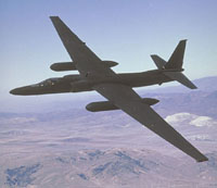 |
| MAJIIC stores intelligence data from platforms such as this U-2 reconnaissance aircraft on specialized servers designed to house large imagery files. Warfighters accessing the MAJIIC system submit queries for specific data to these servers. |
MAJIIC is primarily a software-based system, but it relies on specialized servers. Known as ISR information service servers (ISRISS), this hardware collects data from systems such as groundstations for U-2 reconnaissance aircraft. The ISRISS units will store imagery and sensor data, platform status and mission planning information. Users can access the server and request data with Web-based applications.
Stefansky notes that as the program matures, it will transition to the Air Force’s distributed common ground surface system (DCGSS). The program will provide the DCGSS with network-centric enterprise services, coalition interoperability and risk reduction components, he says.
Storing large imagery files remains a potential issue for the ISRISS, but Stefansky is confident that recent advances in storage technology will mitigate any potential difficulties. However, he notes that after MAJIIC’s initial technical demonstrations, it will have to undergo field tests to determine its military utility. “The warfighters can tell us at that point whether or not there is enough storage capacity,” he says.
Stefansky believes that, in its current configuration, the ISRISS will be attached to specific ground systems for platforms such as U-2s, the joint surveillance target attack radar system (JointSTARS) and Global Hawk aircraft. But MAJIIC is not restricted to those platforms. He explains that it can be attached to any sensor system available, adding that future technologies, such as hyperspectral sensors, will be able to plug into it.
MAJIIC underwent its first technical demonstration in August in an exercise called quantum leap 2. The ISRISS stored JointSTARS ground moving target indicator data for participants to access. The network also carried other data types such as video and electronic intelligence information. For this event, a collateral space was created on the network portal that allowed users to search for data via a central server registry. “With MAJIIC Web servers, you ping the central registry, and it goes out to all the other servers and collects responses that may be able to satisfy your query,” he says.
The program is using commercial and government IP applications to help build the system’s applications for information discovery. “It’s okay to post data to the server, but if the user can’t access or discover it, it’s useless,” Stefansky observes.
MAJIIC is being developed as part of an international coalition with seven NATO nations: Canada, France, Germany, the Netherlands, Norway, the United Kingdom and Spain. The partner nations contribute funds and ISR capabilities in the form of either sensors or a data exploitation workstation. But Stefansky is quick to add that this is not solely a NATO effort. “We are not a NATO ACTD or project. We’re a coalition project. We just happen to be made up of NATO members, but we’d like to play with any potential coalition partners,” he says.
The program is attracting attention from additional countries. Stefansky explains that Belgium, Australia and Sweden have expressed interest in the capability but have not committed to participating.
The program was launched in 2004, and operational assessments are expected to begin in the 2005 fiscal year. The first year and a half to two years of an ACTD program involve technical development, explains Stefansky. During this time, the system’s capabilities will be refined as it undergoes demonstrations in exercises such as quantum leap. Once it is determined to be mature, the system will be assessed for its impact on operational concepts, techniques and procedures.
The operational assessments will be followed by a trans-Atlantic distributed simulation exercise with all of the participating nations. The goal of this event is to test connectivity between sites in the continental United States and the NATO Consultation, Command and Control Agency in The Hague, Netherlands. Larger operational demonstrations are scheduled for 2006 and 2007. Stefansky notes that the ACTD ends in 2008, but as MAJIIC’s capabilities begin to show promise, they will be offered for spiral development into the DCGSS.
The most important feedback will come from the warfighters testing MAJIIC under operational conditions, Stefansky notes. Some uncertainty exists about how commanders will use this tool. “What are they going to do with it? Are they going to trust their assessments, or are they going to want to go back to what they’re comfortable with and have some intelligence analyst provide the exploitation before they make the decision? Are they really going to be trusting enough in their judgment to make the call?” he points out.
Input from warfighters is an important issue because the technology will affect some longstanding cultural issues. Stefansky notes that a commander could be 99 percent certain that his ISR imagery is a tank and 98 percent sure that it is hostile, but the question is whether he will act on this information. “It could be that these guys come back and say, ‘I looked at the information, and based on rules of engagement and blue force tracking, I didn’t want to kill my guys. I didn’t want to make that decision, even though the information was staring me right in the face,’” he says.
Web Resources
U.S. Joint Forces Command: www.jfcom.mil/newslink/storyarchive/2004/pa060104.htm
NATO Consultation, Command and Control Agency: www.nc3a.nato.int
Horizontal Fusion: http://horizontalfusion.dtic.mil/initiatives/page2.html


Comments