Geospatial Intelligence Grows With Conflicts, New Allies
 |
 |
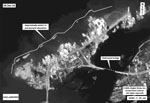
| These commercial satellite images of damage from the Indian Ocean tsunami were processed by the National Geospatial-Intelligence Agency (NGA). The agency increasingly is generating unclassified products for nontraditional partners by tapping commercial geospatial intelligence (GEOINT) sources and adding information to generate a more valuable product. |
Wartime demands and the greater likelihood of coalition operations are changing the way the National Geospatial-Intelligence Agency conducts business. The agency is trending toward products that have lower classification levels to improve coalition interoperability, and it is laying the groundwork for its customers to tailor its products to suit specific needs.
The global war on terrorism has added emphasis to the agency’s challenge of ensuring that its products and services are effective for its customers, declares Vice Adm. Robert B. Murrett, USN, director of the National Geospatial-Intelligence Agency (NGA),
The new intelligence community structure, under the Office of the Director of National Intelligence (DNI), has changed many of the ways the NGA operates and interacts with the rest of the intelligence community, the admiral observes. The new DNI restructuring already has enabled the NGA to do a better job with its intelligence community counterparts.
For example, the DNI’s efforts at data standards have made a difference, as has the work done by the office on resources. “The emphasis that [Director] Negroponte and his team have placed on more in-depth analysis—and just raising the standards we have for analytic efforts across all the agencies—have been very helpful,” Adm. Murrett declares.
At this point in its existence, the NGA has two kinds of opportunities, the admiral states. The first is organizational. For example, in addition to the agency’s enhanced role in the DNI reorganization, the admiral notes that the standup of the U.S. Defense Department’s joint intelligence operations centers, or JIOCs (SIGNAL Magazine, October 2005), includes having the NGA play a key role.
The second category involves technical opportunities. The NGA has fielded new geospatial intelligence (GEOINT) capabilities that are paying dividends, the admiral reports. These capabilities involve a wide variety of sensors that offer a good opportunity to generate new and better products.
And these products increasingly will be either tailored for or customized by the customer. The NGA expects to be working more closely with both its customers and its operational counterparts. To achieve this, the agency will require improved automated tools for performing better analysis and for disseminating intelligence, especially to allies and coalition partners. Industry has made great strides in these areas, he says.
Interoperating with coalition partners will require several different approaches. The agency has personnel from several
The agency currently is striving to provide as much GEOINT as possible to the International Security Assistance Force (ISAF) under NATO that is assuming responsibility for most military operations in
“We may get a coalition-focus environment rather than a
The automated tools that the NGA needs from industry would enable the agency to provide classified information to coalition partners as rapidly as possible. “We need more refinement from industry in terms of rapid dissemination of a broad array of GEOINT products—of various classification levels—to a coalition audience,” Adm. Murrett emphasizes. “It is near the top of the list of the kinds of capabilities that we need.”
Because of the heavy emphasis the force has on technology—including the increasingly vast amounts of data that are being collected—processor technology must keep pace with the broad array of sources and methods that will be coming on line over the next 10 years, he adds.
“The increased amounts of data that we have today make it more important that we are able to sort the wheat from the chaff,” he continues. “The automated tools that we have coming on line, in a generic sense, so far have kept pace with that.” But large data files that include media such as streaming video pose a growing challenge.
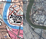 |
| Among the NGA’s recent unclassified GEOINT products is a series of atlases for key areas of Iraq. These atlases are similar to commercial U.S. map books, but they are available only to the military and provide greater detail about what the reader is viewing. |
The admiral adds that the NGA is working closely with the Defense Information Systems Agency (DISA) on the bandwidth issue. This interaction, along with that of other combat support agencies, is vital, he states.
Change detection is another requirement area in which industry has made great strides, and this impacts on the increased thrust toward persistent surveillance. One of the bigger challenges for the NGA to achieve persistence in GEOINT is to have more effective integration of national technical means and airborne sensor platforms, the admiral notes. This entails “fusion of the [data] that we have from both kinds of platforms—and disseminating it in a fashion that has additional benefit for the people that we work with,” he says.
“What we do need from industry is the ability to process vast quantities of data,” the admiral declares. “And, the quantities are getting more and more vast all the time.” The sheer volume of GEOINT that is available today applies to both time-sensitive production and to other needs. This area will need “continued emphasis” for the foreseeable future, he states.
Part of the NGA’s effort to deliver its products to the warfighter involves embedding its employees in combat units in the field. “NGA personnel are deployed forward and are integrated with—and standing alongside—the people who are conducting combat operations,” he relates. “There is probably nothing that this agency does that is more valuable than our individual augmentees [who are] with a whole array of our military forces forward and [who are] providing direct support in terms of the product and services that come from NGA.”
The biggest challenge to delivering the NGA’s products to the warfighter is being able to provide time-sensitive support, the admiral allows. This includes integrating intelligence with the agency’s principal partners to provide a fused, all-source time-sensitive picture. The admiral adds that in addition to GEOINT, this fused picture includes signals intelligence (SIGINT) and human intelligence (HUMINT). This will require providing a fresh product that is on scene, in the same time zone as the warfighters with whom the NGA is working.
This link with the warfighter is a two-way street. The NGA will be receiving vital information from combat forces in theater, and this will be enabled in part by the agency’s embedded personnel. “They have the understanding of the mission set,” the admiral explains, “and they have the ability not just to ensure that their proxy services all are being provided, but also to go up the chain and make sure that what we are doing is as relevant as it could possibly be.”
All of the combat support agencies have learned the value of deployment and being part of a forward team, the admiral notes. This integrated approach ensures that the customer receives the knowledge it needs. “It’s not enough in this business to just produce a product and send it off, and hope that it’s utilized,” he says. “Assured absorption of the things that we produce is our responsibility, and if we don’t do that for our GEOINT products, then nobody else will.”
One of the new products that the NGA has generated as a result of the Iraq War is a series of unclassified books that serves as a multifaceted atlas of
The ongoing war has placed stresses on the NGA, many of which are similar to those challenging other intelligence organizations. One in particular is the need to balance immediate warfighting applications with less time-sensitive, but still important, global responsibilities. For example, Adm. Murrett notes that the agency must continue to focus on issues related to its warning missions while it maintains warfighter support. This is especially true with recent events concerning
For now, the NGA will be working more with materials designed for lower classification levels, the admiral allows. He cites the longtime agency effort of moving products that formerly were highly classified down to lower classifications or even to unclassified levels.
And, the agency will emphasize making broad products available to customers who then can acquire specific items that suit their needs. On-scene NGA personnel will help these customers leverage this capability effectively, Adm. Murrett points out. Customers will have direct access to these products so that they can tailor them to their own requirements.
Adm. Murrett emphasizes that more capable GEOINT systems—both orbital and air-breathing—will provide a range of higher resolution products. Many of these systems will be foreign, and the NGA must be able to keep pace with these international competitors.
In the next five years, the NGA’s changes will be accelerated by the challenges it faces today—particularly the global war on terrorism, which will force the agency “to be as relevant as it possibly can,” the admiral warrants.
The most recent Base Realignment and Closure (BRAC) Commission has directed that the NGA relocate from its current locations to new headquarters in
Web Resources
National Geospatial-Intelligence Agency: www.nga.mil
Office of the Director of National Intelligence: www.dni.gov
Base Realignment and Closure Commission: www.dod.mil/brac


Comments