Satellite Snapshots Fill Imagery Gap
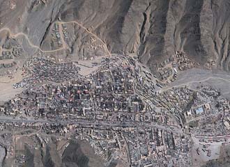 |
This commercially available DigitalGlobe satellite image shows a backup of NATO supply trucks aused when Pakistan closed its border with Afghanistan. |
Coalition partners within Afghanistan and Iraq depend on satellite imagery to support their activities; however, much of the military imagery is only available at the secret and above level. Very few partners have access to this classified data, and this limitation hinders collaboration with national security forces, tribal leaders or other local citizens who support the effort. Furthermore, U.S. Army sources say that Internet-based imagery services such as Google Earth do not provide imagery that is current, has consistently high enough resolution or is government-approved for military applications.
Battalion and company commanders require access to current, high-resolution, unclassified imagery to enhance their partnership efforts at the local level. Commercial resources fill the gap both when the classified satellite photographs are unavailable or when open sharing is required. The Army 1st Space Brigade’s Commercial Imagery Team (CIT) works in partnership with the intelligence community and commercial vendors to provide unclassified imagery for an array of missions in a variety of situations.
The overall Army CIT is divided into five deployment teams, one active duty, two Army Reserve Component and two Army National Guard teams. The teams deploy every nine months to the Kingdom of Bahrain in support of military missions in Iraq and Afghanistan. Some team members have deployed multiple times. The team has worked symbiotically with the National Geospatial-Intelligence Agency (NGA) since 2004, each helping the other in providing unclassified satellite imagery to warfighters as quickly as possible. Commercial vendors—primarily DigitalGlobe Incorporated, Longmont, Colorado, and GeoEye Incorporated, Dulles, Virginia—provide the imagery.
The CIT has a service-level agreement with the NGA that allows the immediate archiving of commercial images. The database of half-meter, panoramic and multispectral satellite intelligence grows by several terabytes every month, according to Army officials. Requests from warfighters for new imagery can be delivered within days, sometimes within hours.
Warfighters have found that when they query Afghanis or Iraqis about the location of homemade bombs, the local leaders and residents are not familiar enough with military maps to recognize the terrain, but they do recognize satellite photographs of the area.
Lt. Col. James McArdle, USA (Ret.), a CIT tactical adviser, deployed with the team in 2007 when the CIT helped the Army to identify and take out a bomb-making operation in a farm house near a major supply route between Kuwait and Iraq. “They knew there was an improvised explosive device factory near their route, and they put in a request for imagery. With that information, they were able to do their planning in conjunction with the coalition partners and the Iraqis and take down that bomb site. That helped stop a lot of bombs from going off,” McArdle says.
If soldiers need to query local citizens in Afghanistan about the location of improvised explosive devices, the CIT can support them with the images they need, but the team also supports humanitarian initiatives, rescue missions and anti-piracy efforts. The team has supplied current imagery in locations such as Kyrgyzstan and the Horn of Africa, for example, where the U.S. military has not operated for decades, and therefore did not have up-to-date maps or images.
When Kyrgyzstan protesters initiated a coup in April 2010, the military needed situational awareness, in part to monitor conditions around a U.S. base at Manas International Airport outside Bishkek. The base serves as a transportation hub for personnel, equipment and supplies to support operations in Afghanistan. “Folks over there reached out to us because this is an area where our forces have not operated and were not expected to have imagery products. After about 29 hours we were able to get the imagery into the hands of the folks who requested it, giving them situational awareness they didn’t have or couldn’t otherwise get,” reports Lt. Col. Gary Curry, ANG, another CIT tactical adviser.
The team also has provided imagery of the Horn of Africa for U.S. forces involved in anti-piracy efforts. The images are clear enough to locate boats operating illegally in the area or hiding along the coastline, where it would be time-consuming and dangerous for anti-piracy forces to search for them. Furthermore, they have provided situational awareness images in South Korea since tensions with North Korea flared last year, and they supported relief efforts during flooding in Pakistan this past summer. During Pakistani flood relief efforts, U.S. forces were able to share the unclassified, pre- and post-flooding images with the Pakistanis, helping to send food and medical supplies into devastated areas. “Having the CIT do their job by providing up-to-date images enabled forces to save lives, time and money helping out our neighbors—providing life support and building bonds between the two nations,” Col. Curry says.
The CIT sends mobile training teams to Iraq and Afghanistan on a monthly basis to teach Iraqi and Afghani governmental organizations to use TalonView, a Microsoft Windows-based mapping application published by the NGA that displays various types of maps and geographically referenced overlays. In some cases, the Iraqi and Afghani personnel have become adept enough with the system to teach it to their compatriots. In those cases, the CIT members simply assist the Iraqi and Afghani trainers.
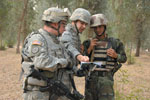 |
A U.S. Army soldier (l) from 3rd Squadron, 3rd Armored Cavalry Regiment and a U.S. Army interpreter (c) look over a map with an Iraqi army soldier from 8th Brigade, 2nd Division, before starting a search of the Ninewa Forest in Mosul, Iraq. In some cases, soldiers need unclassified satellite imagery to coordinate with citizens in Iraq and Afghanistan. |
However, the team expects to complete an upgrade to its communications systems this spring. The effort includes an upgrade from a single one-megabit-per-second line to two direct service lines, each one capable of 45 megabits per second for a total capability of 90 megabits per second. Furthermore, one of those lines will go directly to the team deployed in Bahrain so that data will reach the warfighters much more quickly. The upgrade also will provide a capability to transmit images to any user with a Global Broadcast System receiver, including some remote forward operating bases. “It’s a data burst capability, and it will greatly enhance the way we’re getting imagery out there,” Col. Curry emphasizes.
The CIT also is trying to establish a program of record, which would allow it to support a wider range of missions simultaneously, possibly including homeland security missions or relief efforts in nearby countries such as Haiti. “What we have is exactly what is needed for first responders—those who don’t have up-to-date maps or imagery products. The CIT enables planners, commanders and individuals on the ground to do their jobs—to expedite relief, support or life-saving missions,” Col. McArdle says.
For more information about, or support from, the U.S. Army’s Commercial Imagery Team, contact: For support in U.S. Central Command, contact: |
WEB RESOURCES
U.S. Army Space and Missile Defense Command: www.army.mil/info/organization/unitsandcommands/commandstructure/smdc/
U.S. Army 1st Space Brigade: http://bit.ly/emgJwQ
U.S. Central Command: www.centcom.mil/


Comments