System Weaves Many Strands Into One Picture
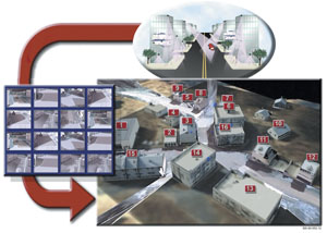 |
| The persistent surveillance and dissemination system of systems (PSDS2) is a command and control tool that allows warfighters to integrate and filter live sensor feeds to enhance situational awareness. This data can be superimposed on a three-dimensional terrain map to create a single tactical picture, and it can be stored and replayed for future analysis. |
The
The persistent surveillance and dissemination system of systems (PSDS2) is designed to integrate existing capabilities such as video, radio frequency and acoustic sensors and to put the gathered information into context. Once filtered, the data permit operators to make decisions more accurately and quickly, explains David Pope, Raytheon Company’s PSDS2 program manager,
Pope describes PSDS2 as an end-to-end system concept. By integrating a number of incoming data streams, users no longer have to move between different applications to accomplish a task such as monitoring multiple camera images. The system is designed as a decision-facilitation tool. “A commander can use all of the existing capabilities to make the decision as quickly and accurately as possible and get it out to somebody who can do something,” he says.
In December 2004, the U.S. Army’s Program Executive Office, Intelligence and Electronic Warfare Systems,
Pope explains that the customer initially came to Raytheon with a request for information about the firm’s capabilities to meet the requirements. The customer then returned and asked for the system based on Raytheon’s responses regarding cost and time to operation. PSDS2 is a spiral development program with 120-day development cycles. The government already has asked for additional capabilities as a result of operational experiences. These requests include reduced size and additional interfaces for sensors and systems for collecting and distributing data, he says.
PSDS2 has a plug-and-play capability that allows different sensor systems to link into it. Its software also can be set to identify certain behaviors, such as an individual leaving an object in a location then walking away, and to highlight this activity as an alert, which can appear as a flashing red highlight around the object in question.
Raytheon’s engineers used intelligent software algorithms to free operators from watching multiple screens to detect an event. “It will give users a trigger based on the criteria that they have set. They can go back and see if it is really something that they are interested in, or they can take the results of that search and forward the information on to people who can take action,” he says.
Pope describes the system as a force multiplier because it allows a small number of operators to process a large amount of data. He adds that the software architecture can be modified to suit individual user needs. A graphic user interface permits users to establish a set of filters for every sensor in a particular area. For example, a camera overlooking a restricted area can be set to trigger an alert for any detected motion. In heavily trafficked areas such as airport corridors where pedestrian traffic moves in one direction, sensors may sound when an individual moves in the opposite direction or leaves a package behind.
PSDS2 can create “green” and “red” areas in specified zones and can alert operators if a person or vehicle moves from one area to another. “There are a number of parameters you can set. For an object left behind, if you were looking for an automobile that has stopped in a certain area, you’d set the parameters for something big. If you’re looking for a small package, you’d set them for something small. You can also change the time thresholds—there is a lot of tailoring that can be done for whatever situation you’re trying to deal with,” Pope explains.
The system features a variety of methods to speed the command and control decision-making process. It can overlay live sensor feeds onto a three-dimensional map of a city or neighborhood that presents ongoing activity in context. Specific incidents can be tagged with an “event folder” that marks an area for persistent surveillance.
Pope notes that the system can record continuous video and sensor feeds for more than 20 days. This data is stored on disc, allowing analysts to select specific events for review. The documented information provides data feeds for all of the cameras in a given area, allowing analysts to compare video from multiple cameras at the time of interest, he says.
PSDS2 features several major software tools: Video Flashlight, Hawk, Event Portal, Video Portal and Vision Alert. Video Flashlight organizes and automates individual video feeds. It also provides a mosaic of video images to create continuity between linked cameras, and it can overlay this information on a three-dimensional model. Hawk software coordinates information from video and non-video sensors and provides geographical references for surveillance imagery. The Event Portal is a real-time dissemination system for registered users that is a repository for PSDS2 data records. It can provide event data, tracks, video feeds and images to any user on the secret Internet protocol router network. The portal also features data mining tools for forensic information searches. The Video Portal provides real-time streaming video feeds to authorized users, and the Vision Alert application allows administrators to set alert criteria for sensor data.
The software-based system runs on standard Windows platforms. It also can be hosted on different computers and moved between platforms, although this requires some hardware and software integration, Pope explains. For example, if the system is moved to a new platform or operating system, such as Windows XP to Windows 2000, a small amount of integration is required.
 |
| The PSDS2 system can integrate data from a variety of sensor systems such as this Raven unmanned aerial vehicle in Iraq. After the data has been processed by the system’s operators, the information can be quickly disseminated to a variety of fire control and battle management systems. |
The original version of PSDS2 is in a 20-foot x 8-foot x 8-foot container, but the latest variant occupies 60 percent to 70 percent less space. Pope adds that the mobile version can be installed in a vehicle, but it does not have all of the tools available to the fixed-site version.
Flexibility is a key requirement for the system’s open architecture. Pope explains that PSDS2 had to interface with existing equipment in the field without any changes or major configuration issues. The open architecture is important because any number of applications and technologies may become available in the coming years and the system must be able to accommodate them. “We had to have a fairly flexible architecture to allow us to do that,” he says.
As a tool for network-centric operations, Pope explains that PSDS2 can distribute information across a network. It permits small groups of operators to distill data, identify key events and post them on a Web portal that is available to anyone who is connected to the network and has log-in authorization. “That could be anywhere in the world, not just across the hall,” he says.
Besides accepting information from a variety of sensors, PSDS2 interfaces with current weapons and reconnaissance systems such as the Predator and Shadow unmanned aerial vehicles. In addition, it interoperates with command and control systems such Blue Force Tracking, Force XXI Battle Command Brigade and Below terminals, and the Advanced Field Artillery Tactical Data System. Pope adds that posted information is useful for both tactical and strategic operations.
One component of PSDS2 is the distributed common ground systems information backbone, which provides a uniform set of capabilities for use across an entire enterprise. This capability allows information to be easily exchanged between multiple sites, he says. In addition to facilitating information sharing across the network, it permits material stored in databases at one site to be replicated at other nodes in the network to create a common picture, he says.
PSDS2 can be applied to a variety of uses beyond combat. For example, a city police department or a transit system can use it to monitor security cameras and sensors. Pope notes that it could connect users to a 911 network automatically to alert emergency responders.
The system also features wireless protocols that allow video and imagery to be transmitted to handheld devices. Pope notes that commercial applications can be plugged into the system, permitting users to receive any video channels that administrators wish to put across the network. Although this capability is not currently available in the system, it could be installed quickly, he says.
Web Resource
Raytheon Company: www.raytheon.com


Comments