NATO Deploys Command and Control Tool In Afghanistan
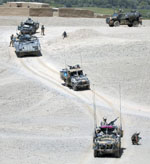 |
The Networked Interoperable Real-Time Information Services (NIRIS) enhances commanders' situational awareness and provides military and civilian convoys operating in Afghanistan with real-time alerts to security threats such as improvised explosive devices (IEDs) and potential ambushes along their routes. |
Coalition forces in
The recent upsurge in Taliban attacks on humanitarian aid workers and convoys, along with the planting of improvised explosive devices (IEDs) along major supply routes, led NATO to issue an urgent need request for a real-time situational awareness capability. The alliance’s Technology for Information, Decision and Execution Superiority, known as the Networked Interoperable Real-Time Information Services (NIRIS) system, integrates existing national communications systems to move operational data across all echelons and security levels.
This capability to avoid IED attacks and to manage convoys originated from a NATO urgent operational requirement issued in October 2008. Dag Wilhelmsen, general manager of the NATO Consultation, Command and Control Agency (NC3A),
The rapid development process allowed an enhanced NIRIS product to be fielded initially in
Another part of the NC3A's support tools is a logistics planning and coordination system called the Coalition Reception, Staging and Onward Movement (CORSOM). NATO is working with its member nations to manage the reception, staging and onward movement of supplies and materiel into and across
He notes that a variety of civilian and military vehicles use
Wilhelmsen observes that many of the information sources needed by NATO forces and non-governmental organizations (NGOs) are available on the Internet. This Web-based data can be imported into a single repository managed by NIRIS, so a multidisciplinary team working under the NC3A has combined these various capabilities into NIRIS.
Wilhelmsen adds that NIRIS's capabilities will grow as new data sources are brought into the network. This information will come from a variety of sources such as military blue-force tracking systems, incident databases and local reports of IEDs. Threat incidents and suspected ambush areas will be sited onto digital maps that can be displayed in command posts and on vehicle-based command and control systems.
NIRIS also includes military information such as the location of troops and command posts. Wilhelmsen says that this military data is useful in situations where civilian convoys report an attack or IED incident, because it allows commanders quickly to determine the location of the nearest troops to respond to the situation.
Other organizations such as the United Nations and the Red Cross also operate in the region. Wilhelmsen explains that one of the main challenges is obtaining data from and providing security information for groups such as the World Food Organization while not appearing to openly support them: It is critical that NATO avoid interfering with their work or making them targets. Trust between the civilian organizations and NATO is key in this tactical situation, he says.
The information disseminated via NIRIS is visualized via several functional services such as CORSOM, interim Geo-Spatial intelligence tool (IGeoSIT) and Integrated Command and Control (ICC) systems, which allows these groups to have a standoff security presence that enables them to work with the local population without the need for obvious heavy military escort. “The key point here is joint situational awareness for all parties involved in supporting the Afghan government in rebuilding the country and ensuring secure governance and the livelihood of the Afghan people,” he says.
However, Wilhelmsen notes that IEDs pose a threat to everyone traveling the nation’s roads because these weapons do not distinguish between civilian and military targets. Unlike the more sophisticated weapons used by insurgents in
CORSOM also features a planning and deconfliction capability that permits convoys to plan around traffic jams. The system allows commanders and civilian convoy coordinators to know if there are traffic issues or insurgent activity in a region. Local military units can enter situational data into the network to alert other groups operating in the area. Wilhelmsen explains that the roads winding through the mountains can become blocked with traffic quickly, which attracts potential attacks. “You don’t need to send 400 trucks to a jammed border crossing,” he says.
 |
IED attacks against civilian and military vehicles have increased dramatically in Afghanistan. The NIRIS capability allows warfighters, such as this Dutch soldier disarming an IED, to post alerts on NATO operational networks. Any NIRIS-equipped vehicles in the area will be alerted immediately to the possibility of IED attacks along this route. |
Designed for coalition operations, NIRIS can transfer data to individual national command and control systems. But while NIRIS provides information across echelons and nationalities, Wilhelmsen cautions that the data transfer is not entirely seamless because of security devices between domains. He believes that it will take several additional developmental steps to smooth out information sharing before the system achieves full operational capability. NIRIS initially is being deployed to military units before being provided to civilian users.
To ensure interoperability and real-time unit tracking, NATO is working on datalink standardization and translating different national formats into a common, Web-based, extensible markup language (XML)-based code. This language allows data to be imported from different systems into a unified operational picture.
NIRIS provides convoy information via two different formats: the Over-the-Horizon Gold text format and the NATO Friendly Force Information (NFFI) format, an XML-based protocol. Data is contained in individual tracks with basic operational information about a convoy. This information is harmonized with military blue-force tracking systems and air data to prevent conflicts, Cadamuro says.
The software uses a machine-generated and -read symbology to avoid errors in the operational and location data. “To ensure quality, we base all our implementation on XML standards in machine-readable formats,” Cadamuro explains.
Wilhelmsen adds that the NC3A is working with a variety of technologies and requirements to field NIRIS over short- and long-term schedules. The agency now has a structure in place that allows it to respond quickly to urgent requirements by finding and placing solutions into operational systems. But he cautions that it is important to provide not only the technology but also the full training and documentation to make it sustainable in the field.
To ensure that all of the alliance’s command and control systems are fully operating and serviced, the NC3A has established a field office in
WEB RESOURCES
NATO Consultation, Command and Control Agency: www.nc3a.nato.int
NATO Programming Centre: www.npc.nato.int
International Security Assistance Force: www.nato.int/isaf


Comments