Israel Exploits Space Technologies, Capabilities
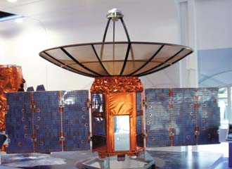 |
Israel’s TecSAR 1 satellite has been operating since 2008. TecSAR II is slated for launch in the near future. |
Israel has extended its defensive reach into space with families of remote sensing and communications satellites. An evolutionary process coupled with technology insertion has generated advances in space-based capabilities that offer direct results to warfighters on the battlefield.
Israel’s interest in military space is self-evident: to optimize battlefield and security effectiveness using space-based assets. Lt. Col. Oren Barda, IAF, head of the Israeli Air Force Space Branch, explains why Israel considers space to be so important for international security: “First, we must stand guard for any possible threats. Space enables long-range surveillance, space enables working in neutral territory, and space is a technology and economic booster to industry.”
Inevitably, both worldwide and regional trends influence Israel’s space requirements for defense and security. Col. Barda says, “We see a rapid evolution of long-range strategic and existential threats by states and nonstate organizations, both global and local. Many of them are accessed only from space. Political difficulties mean traditional threats have increased. We see conventional and unconventional ballistic missiles increasing in range and number.”
These trends, Col. Barda points out, demand the development of advanced sensors and algorithms such as the hyperspectral Ground Moving Target Indicator and Moving Target Indicator, both of which have the flexibility to operate in all weather, day and night. So, they can counter the increased use by opponents of mobility, stealth and camouflage, coupled with subterranean activities to escape detection.
To meet these challenges, Israeli space-based security needs require a full range and variety of synthetic aperture radar (SAR), infrared and hyperspectral sensors—coupled with the capability to launch on demand to various orbits and inclinations—to produce high-quality reconnaissance with high resolution and extended area coverage. Key technology areas identified to enable this include a stereoscopic capability for three-dimensional digital terrain model mapping; enhanced command, control, communications, computers and intelligence in all areas of operation; and increased alert times for ballistic missile defense.
Col. Barda notes that the applications are wide-ranging, from intelligence for real-time added value, weather forecasting, navigation, frequent target visiting for early alert and understanding patterns of operational vulnerability and battle damage assessment.
Israel has used the Shavit family of launch vehicles, which operate from Palmachim Air Force Base. The colonel says that Israel has had 13 successful launches, and he claims 100 percent “in orbit success,” all with small satellites. Israel currently has four surveillance satellites employed day and night in an operationally responsive constellation with what Col. Barda describes as good cost-to-weight ratios. He adds, “We believe that the main reason [for success] is focusing on one mission: small satellites that are between 300-400 kilograms and have superb image capabilities and responsiveness.”
Israel’s space capability began with the Ofeq 1 and 2 satellites, both technology demonstrators. Ofeq 3, launched in 1995, became Israel’s first operational Earth observation satellite. The second-generation system began with Ofeq 5, and the latest in the constellation, Ofeq 9, launched in June 2010.
“The capabilities consist of an electro-optic constellation of three satellites,” Col. Barda says. “This constellation provides us with multiple visits in day and night, with multiple targets with each passing.”
Ofeq 5 and 7 provide considerable enhancement over Ofeq 3, notably the improvement in imaging resolution from 1.8 meters to 67 centimeters. They also feature onboard data storage for when the satellite is out of communication range.
Cumulatively, these satellites provide multiple visits to an area of interest and the ability to image multiple targets in each passing. Col. Barda relates that the constellation collects 38,000 images per year with 48,000 square kilometers covered every day.
Meanwhile, Israel’s TecSAR 1 satellite has been operating since 2008, providing 150,000 fine-resolution images annually with 30 per orbit. TecSAR can be operated in three modes: spot mode; strip mode with wide-area synchronous scanning of a length of greater than 3,000 kilometers at rates of 5,000 square kilometers per minute; and a mosaic mode that also features electronic beam steering to focus investigation of widely spread threats in high resolution.
“TecSAR 1 can provide two to three revisits a day for a specific target, and we are now producing advanced interferometry products for change detection,” Col. Barda points out. “The TecSAR satellite provides us with the capability of responsive and agile control. Because the imagery antenna is also the communication antenna, we can provide a small ground station like a small vehicle and provide mobile solutions for forces in the combat areas.
“The TecSAR imagery provides us with day and night, all-weather and advanced imagery modes and up to 100,000 square kilometers covered in a day. Our systems allow for very short times from tasking to dissemination,” the colonel continues. “We have developed a very high geolocation [capability] for sensor-to-shooter applications. We are also proud of our mapping capabilities.”
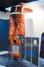 |
The third-generation Earth observation satellite OptSat 3000 will be capable of collecting roughly 50,000 images per year. |
Beyond defense and security activities, Israel has embarked with France on the Vegetation and Environment monitoring on a New Micro-Satellite, or VENUS, for scientific and technology missions. This satellite monitors vegetation and water quality using a 12-color multispectral camera and, by being in a precise orbit, provides geolocated data providing the same location every two days.
OptSat 3000 weighs roughly 400 kilograms and will use a high-resolution panchromatic and multispectral telescope capable of a high geospatial accuracy comparable to commercial services. It will feature gimbaled X-band antennas and will be capable of collecting roughly 50,000 images per year with 30 per orbit.
Over the years of the Israeli space program, two main evolutions have taken place. The first was the establishment of a single bus for its satellites. Israel’s third-generation satellite systems will feature a multipurpose common bus with a dry weight of 190 kilograms across OptSat 3000, TecSAR II and VENUS.
The bus has the ability to provide absolute position knowledge at a maximum velocity of eight degrees per second and acceleration of half a degree per second. The system is powered by a 45 ampere-hour lithium ion battery with solar panels capable of generating 850 watts of power. With the bus requiring just 90 watts on average for its operation, 760 watts of power are available for the payload, with the satellite hosting payloads of up to 180 kilograms. Command and control of the satellite is provided via an S-band datalink, with an X-band downlink for the payload capable of 600 megabits per second. Imagery also is stored on the bus via dual, fully redundant 120-gigabyte onboard recorders. The bus uses eight 5-Newton (N) thrusters for attitude control and dual 25-N thrusters for orbit control with 30 kilograms of propellant carried onboard.
The second evolution in Israel’s space capability is the establishment of a unified ground station. This consists of one station for all low-earth-orbit (LEO) satellites with a backup station for survivability. The station is used for tracking, command and control downlinks and data dissemination, which consists of near-real-time distribution that can be sent directly to the theater. Time from tasking to dissemination is less than three hours.
While the structure for Israel’s future space capabilities is now formalized, the underlying vision explains the strategy and points to the future direction of capabilities. The strategy is an architecture based on three levels: microsats, LEO and geostationary, or GEO, satellites.
The first field involves acquiring advanced surveillance capabilities for all-weather day/night imagery and diversity of sensors, including advanced SAR and hyperspectral. This will be accompanied by a more extensive SAR Earth observation constellation that will communicate with others. “This will allow us intensive real-time data transfer with all participants on the battlefield,” Col. Barda notes.
“We see in the future a much more responsive space capability that consists of launch on demand, anytime, anywhere, and where aerial launch is a much more available and flexible solution for launching something,” he adds.
Outlining Israel’s microsat strategy, Col. Barda says that he expects the micro-satellites to cost less than $15 million and to be available for launch within weeks—“some say days,” he adds.
Microsats weighing just a few kilograms will operate hand-in-hand with nonsatellites. The colonel outlines the potential roles of microsat payloads as including local navigation, communications and risk reduction activities for larger satellite programs. “We see a more tactical space as the next step based on smaller satellites in lower orbits as gap fillers, new complementary capabilities such as ballistic missile defense and real-time communication,” he says.
Col. Barda also indicates that Israel is seeking greater cooperation in space, in addition to and beyond the scientific cooperative endeavors of VENUS. “From the Israeli perspective, we believe that there are many opportunities in space for international cooperation,” he explains.
This could be in a variety of areas, and he cites as possibilities the sharing of launch capability and launch sites to overcome geographical constraints along with providing mutual backup of assets and a combined asset base among allies—as well as the sharing of space situational awareness.
Col. Barda demurs about antisatellite capability details, but he notes that China’s test in 2007 resulted in a lot of orbital debris. “I think we should try to consider a cleaner solution and try to involve new technologies for practical solutions, quieter solutions,” he adds.
Adam Baddeley is a freelance writer.

Comments