Sandia National Laboratories Experiments With Cellphone Signal Navigation

In cases where GPS satellites may be degraded or unreliable, researchers from Sandia National Laboratories and Ohio State University are considering cellphone towers as alternative sources of signals to create a backup navigational system for airplanes.
Sandia National Laboratories shared on October 22 that a team of researchers in New Mexico is piloting a navigational system using alternative signals emitted from the ground and non-GPS communications satellites in the sky to determine a vehicle’s position and velocity.
While GPS is still largely reliable and used by people every day in several different ways, Sandia lead researcher Jennifer Sanderson said it’s better to have a backup plan in case GPS connection is ever disrupted, which would make air travel dangerous for pilots and passengers.
“Commercial GPS receivers are susceptible to a couple different threats, one being jamming,” Sanderson said in a press release. Jammers are used to overwhelm receivers with meaningless signals and can throw aircraft off their flight path.
Sanderson also said spoofing, using a fake signal to disguise the real location of a vehicle, is a threat to airplane safety when a pilot can distinguish a genuine signal from a spoofed one. Additionally, GPS signals are more likely to get disrupted in areas of conflict.
Signals of opportunity measure the physical characteristics of radio frequency waves instead of relying on GPS signal time and location information. By measuring how compressed the radio waves are while a satellite is moving, scientists can calculate how far the satellite is from the receiver.
While signals of opportunity are usually used on the ground where GPS signals are blocked by buildings, Sandia’s researchers are testing this navigation strategy at high altitudes.
The experiment consists of strapping antennaed foam coolers of electronic packages, what the team calls payloads, to weather balloons and launching them into the air to collect signal data from the stratosphere.
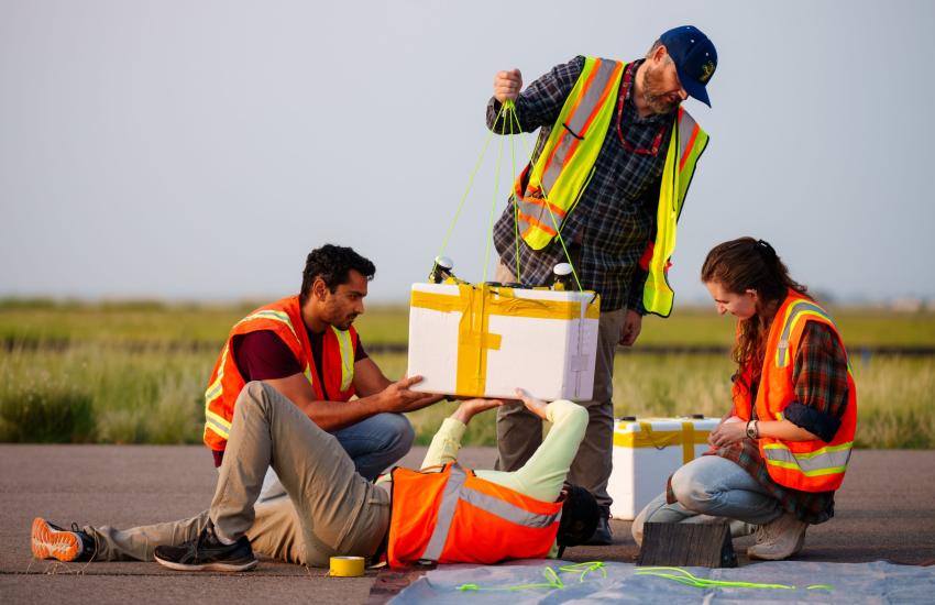
The team reached its highest altitude at around 80,000 feet to test the satellite signals above the clouds. According to Sanderson, the research team is aware of the dead zones above the rural areas of New Mexico, so the early stages of experimentation are about identifying error sources in navigation.
After sending the balloons into the air, the team has been recording data to then process and analyze. Sanderson said her goal is to obtain a reliable dataset to help develop algorithms and enable hardware tests for “live-sky data.”
According to Sandia’s release, the focus now is still on manually matching received signals to nearby satellites, but eventually the navigation system will need to match signals to their transmitters in real time and calculate velocity and position automatically.
“While we are still processing the flight data, we believe our preliminary findings indicate that we detected cell tower signal beacons at our peak altitude of about 82,000 feet. If these signals are clean enough for navigation, it will significantly change what we thought was possible for alternative navigation,” Sanderson said.


Comments