Synchronized Data Operationalizes Sea Service Effectiveness
Mariners can obtain situational awareness of surface maritime traffic by looking out to sea and by using devices such as radars and automated identification system transponders on ships. These systems can identify vessels along with pertinent data about their voyage. But these methods have limitations. Master mariners with powerful binoculars can tell a lot just by looking at a ship far off in the distance; however, they can’t see beyond the horizon, in bad weather or at night. The horizon even limits radar and transponder data can be manipulated or deleted.
It’s a huge challenge. The ability to detect and mitigate threats at sea requires extracting and processing information from numerous and diverse sources through efficient and advanced techniques and methodologies.
The NATO Science and Technology Organization Centre for Maritime Research and Experimentation (CMRE) Data Knowledge and Operational Effectiveness (DKOE) program addresses NATO’s capability gaps and interoperability requirements in the maritime data and information domain. Through information processing, big data analysis and prediction tools, the program contributes to the organization’s maritime situational awareness (MSA) and information exchange between NATO nations.
Previously known as the NATO Undersea Research Centre, the CMRE facility in La Spezia, Italy, features a team of scientists, engineers, technicians and support staff. At the CMRE, experts conduct scientific research and technology development in the maritime domain to deliver innovative and field-tested science and technology solutions to address defense and security needs of the NATO alliance.
The international maritime community understands the challenges of identifying vessels and their intentions—wherever they may be—and recognizes the need for maritime situational awareness as well as the ability to share that information with stakeholders.
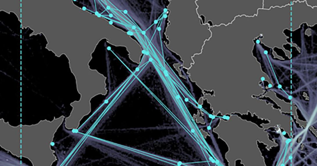
There are more than 50,000 merchant vessels engaged in international trade. In addition, many more are involved in passenger services and domestic, coastal and inland waterway shipping. Pleasure craft, tugboats, barges and fishing vessels also transit across waterways.
Ships weighing 300 tons or more and craft engaged in passenger service continuously transmit updated information about the vessel through onboard automated identification system (AIS) transponders. This information is shared with authorities onshore and other AIS-equipped vessels nearby. AIS data includes a ship’s name, call sign, dimensions, type, position, course, speed and vessel status.
This technology improves situational awareness by reducing the risk of collisions; however, an enormous amount of maritime traffic data exists and increases every minute.
The CMRE’s DKOE team has developed algorithms to analyze AIS and other data to show authorities what “normal” looks like at a given time and area of the ocean. Anomaly detection techniques DKOE developed can help operators identify abnormalities in the vast data available, resulting in more comprehensive maritime intelligence.
“DKOE research and tools provide NATO and nations the most advanced solutions to support the future development of NATO’s Maritime Command and Control Information Systems,” says Anne-Laure Jousselme, scientist, CMRE.
She explains that identifying abnormalities can be like looking for a specific needle in a huge stack of needles. Understanding the large amount of data of the many normal at-sea activities helps scientists to spot unusual activities. Looking at this data, as well as the past, current and projected locations of vessels, helps analysts find anomalies that bear scrutiny and possibly interdiction.
The ability to collect and fuse different types of data from different sources provides information that is useful to NATO nations. It is critical and a strategic capability for the alliance, Jousselme says.
Even if a ship is exhibiting unusual behavior or has its AIS turned off, a security concern is not necessarily warranted. Context and poor quality sensors or sources may explain the behavior. To address these situations, the CMRE has developed methods to support human reasoning in uncertain circumstances by providing the tools to fuse a variety of data sources, handle source quality and reason within context. In addition, with artificial intelligence and machine learning, big data processing can lead to forecasts and predictive analysis.
The CMRE’s DKOE project researchers are applying the diverse fields of statistical signal processing, machine learning and information and data fusion. They are employing artificial intelligence, reasoning under uncertainty, gamification and semantic knowledge representation and reasoning to provide generic and flexible solutions to a wide range of MSA problems.
“Data is the core of everything we do,” says Alessandro Berni, chief information officer, CMRE. “We collect and analyze data with different tools and make those results available to stakeholders. This has not changed much in 60 years.
“What has changed is the way we do it; the tools we use to do it; the speed with which we do it; and the relevance and impact we can deliver,” he adds.
Over the years, Berni states, the CMRE has delivered transformational discoveries in understanding the maritime environment for the benefit of operations such as antisubmarine warfare, mine countermeasures, and intelligence, surveillance and reconnaissance.
Now, he says, the problem set has become much more complex. “In the past, data was a very scarce resource. Today, our ability to produce data has increased exponentially,” he relates.
According to Lt. Kathryn Ransom, USN, stationed at the CMRE and working with the DKOE team, all that data poses challenges. “There are two parts to the challenge,” Lt. Ransom says. “The first is how we handle the volume of AIS data and satellite tracks, and the second is the reasoning behind how we process the data.”
During the International Maritime Exercise 2019 (IMX19), a U.S. Navy-led event in the Middle East involving 50 nations, the CMRE DKOE successfully integrated output from its Maritime Pattern of Live System (MPoLIS) using SeaVision, a web-based MSA tool the U.S. Department of Transportation operates that enables users to view and share maritime information.
The CMRE also has contributed pattern of life, vessel position prediction and behavior analysis software to the European Commission-funded Maritime Integrated Surveillance Awareness project (MARISA). These contributions allow the project prototype to determine the probability of vessels conducting illegal activities.
In addition to looking for security threats, the system can identify vessels conducting illegal or unlicensed fishing, black-market bunkering, smuggling, human trafficking or hazardous materials dumping. The system can then use historic data to trace a vessel back to its origin or see if that vessel has been involved in illegal or suspicious activities in the past.
The CMRE DKOE team has used its expertise in the cognitive processes of perception, comprehension and projection to deliver and validate novel approaches to solve a range of MSA problems.
“The technology DKOE provides is aimed at improving the recognized maritime picture with fewer false alarms and increased time-on-target,” DKOE scientist Paolo Braca says. “We are establishing the baseline for maritime traffic analysis and the ability for early detection and management of abnormalities. By helping relieve the cognitive workload of operators, NATO nations will be able to better utilize their personnel to conduct efficient and effective operations.”


Comments