Image Tagging Stores Vital Data
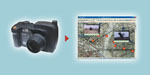 |
| FoxView resides on rugged digital cameras such as this Ricoh 500SE-M tactical digital camera. The software tags photos with location data from the camera’s internal GPS unit and other data such as azimuth and information about the unit taking the image. |
A data capture and marking technology permits images to describe where and by whom they were taken. The capability allows warfighters to take photographs on the battlefield that have embedded location coordinates and other data. These coded images then are loaded onto digital maps of a region. Studded with hyperlinked information, these maps provide commanders and analysts with immediate information about their operational zones.
One example of the information-tagging applications being used by the U.S. Defense Department is the FoxView data-logging tool. Designed as a plug-in for the FalconView digital mapping software package, FoxView allows troops to take geographically coded images that can be loaded onto FalconView maps for dissemination and archiving.
The FoxView application was designed to enable soldiers to make sense of a tactical mapping environment, says Matthew Kidd, president of Geo Tactical Solutions, Parker,
While FoxView is designed to work with FalconView, Kidd adds that his firm also has developed a version that interoperates with Google Earth. He explains that FalconView is a platform utilized by many military users because of its simplicity. The U.S. Air Force began using FalconView as a flight planning tool, but ground forces such as the U.S. Army and U.S. Marine Corps soon appreciated its simplicity for their mapping needs. FoxView is designed to be device-agnostic and to plug and play with a variety of equipment and software systems, Kidd says.
As a plug-in application for FalconView, FoxView allows users to receive geocoded photographs and insert them into tactical mapping programs. Kidd shares that simplicity and ease of use were important considerations when FoxView was developed because operational photographs are usually taken immediately after a mission, either for post-battle assessment or intelligence purposes. Such post-mission photographs often are taken by exhausted soldiers distracted by other responsibilities. “We don’t want to have a process that’s laborious or time-consuming. It’s got to be simple to follow,” he says.
The application can be operated via a simple user interface featuring four main buttons that activate drop-down menus. The menus allow geospatial data to be inserted into the photographs, and the interface also permits the creation of reports. This tool enables users to convey additional data to other recipients. Report files are stored in Microsoft Word files. Kidd explains that Word was chosen for this feature because of its ubiquity and the broad familiarity many users have with the software. This material can be created in a few minutes by soldiers in the field, he says.
The photographs then are loaded onto digital tactical maps. The camera’s tracking log function indicates where the unit has been and records its GPS coordinates. Besides creating reports, the software also creates mission folders that allow soldiers to file all of the material gathered in a mission in one place for debriefing. FoxView previously was known as DataManager. Kidd notes that this originally was created in March 2007. He adds that his firm is constantly releasing new versions based on feedback from users in the field.
To load data for use, FoxView uses an accompanying program called List Editor, which provides an interface where data memos can be named. This creates a repository to collect time and location data as they are captured. The Editor program also allows users to add more or less information to photographs. For example, the photographer can list specific categories of photographs, or they may post their names on the pictures. Multiple names can be stored in the camera. When a photograph is taken, the user can select from a menu of names to tag the picture.
In the first quarter of this year, a new feature will be added that can be coupled with a laser range finder and a digital compass. This new capability will enable users to obtain the location data of an object some distance away from the photographer. As with Google Earth, the azimuth feature allows a user to view a particular perspective on a digital map. Coupled with a laser range finder, the new release will allow the data to be stored with its representative location and a field-of-view cone. From the photographer’s location, stretching out to the location of the object in the picture, will be a line indicating its relative range. For example, a digital map may have an image of a hill and several buildings on it. FoxView allows each of the buildings to be photographed and their ranges listed from a particular angle. “It lets you know where an object is located,” he says.
The ability to tag and load information onto digital maps is a very important tool for warfighters, explains a Marine Corps captain who asked to speak on background. An intelligence officer who served in a reconnaissance battalion and in transition teams working with Iraqi forces in 2008, the captain says that he has used GPS-enabled cameras since 2005. He notes that the capability eliminates the multistep process of picture taking. “From an intelligence analysis point of view, if you can’t tell me where that picture was taken, it doesn’t do me any good,” he says.
Automatic tagging eliminated the need to photograph the GPS unit or write down the location data for every photograph taken. For intelligence officers, the captain notes that it is easier to provide troops with a camera that does this work than requiring them to log all the data after a long mission. While tagging is a vital capability, he cautions that the challenge lies in processing and displaying the photographs. After pictures are taken, they must be embedded into an electronic map where they can be pulled up automatically. Over time, these photographs are logged into a database of the unit’s operational area. A particular location can be photographed over a period of days or weeks to monitor activity.
The captain says that he used FalconView because of the FoxView plug-in application and its capability to generate files to work in FalconView. He adds that FalconView in itself is not an analytical tool, but it provided a template that allowed him to call up photographs of an area and hyperlink them to a map. “Being able to link a photo to a location on a map is extremely powerful from an analysis perspective,” he says.
The captain shares that Marine Corps planning and analysis operations are now practically paper free except for printing out target information. The capability enables officers to call up electronic maps and pull up photographs of specific areas for analysis and assessment. The captain adds that when he was in
Web Resource
Geo Tactical Solutions: www.geotacticalsolutions.com


Comments