What Is Old Is New: Surface Mine Waste Presents a Possible Supply of Critical Resources
The U.S. Geological Survey (USGS), the federal, science-based agency that assesses the mineral resources of the United States and tracks production, use and trade data of 100 minerals, is pursuing a nationwide effort to identify and map critical mineral resources. More than 50 nonfuel-related minerals, such as cobalt, gallium, graphite, lithium and magnesium, are identified as necessary for U.S. national security, energy, medical and infrastructure needs.
For 21 of those critical minerals, the United States is 100% dependent on imports of those commodities.
The USGS Earth Mapping Resources Initiative (Earth MRI) is underway in its nationwide effort to build fundamental geoscience data sets of these minerals. The effort will allow the United States to understand its potential resources, improve its supply chain to obtain more of these critical minerals domestically and strengthen national security and the economy.
The effort began in 2019 and was greatly expanded in 2021 with directed funding outlined in the Bipartisan Infrastructure Law passed by Congress. The legislation outlined the need for the United States to understand its critical mineral resources, in part to reduce its dependency on foreign supplies, especially as adversaries, such as the People’s Republic of China, are dominant in critical mineral supply and processing.
Given that the USGS is not a mineral production agency, its mapping, products and data present a fundamental understanding of the science and possible resource areas for industry and other organizations to then investigate further for commercial production, explained Earth MRI Program Manager Darcy McPhee.
“The Earth MRI is an initiative that sits within the USGS Mineral Resources Program and is an effort that was started to map and collect data across the nation, with an interest to really get an understanding of what the geologic framework of the nation is, with a focus on critical mineral resources,” McPhee said. “We are collecting fundamental geoscience data that will allow us to understand the geology and the subsurface geology of the country as a whole.”
While the USGS has been collecting geophysical data for decades, the need for high resolution data—including hyperspectral imaging—is driving the organization’s latest efforts. “Our country is so big, and we have a lot to cover,” McPhee said. “And so, we are pretty under-mapped when it comes to very high-resolution, detailed, state-of-the-art geoscience data sets,” she clarified.
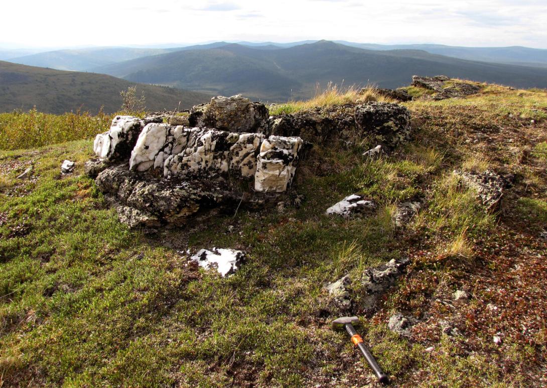
The United States, with its rich mining history that includes the famous gold rush of the 1850s and the boom in silver mining in the following decades, presents possible supplies for the modern day from its mine waste. This surprising possible source of critical minerals stems from societies valuing different minerals across time. The almost singularly focused hunt for gold or silver ignored other minerals that are now part of the mine waste.
As such, the USGS is now putting a significant effort into mapping possible supply areas of critical minerals in mine waste and surface deposits across the country. Earth MRI is developing three types of data, geologic, geophysical and topographical information, which will help characterize the distribution of critical minerals and identify regions in which more data is needed.
“We are not only looking at the potential critical mineral resources below the ground, but what can we map above ground in mine waste,” McPhee said. “There could be some sources of critical minerals just sitting on the surface of the Earth.”
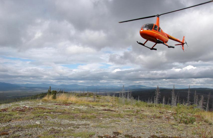
The 2021 law enabled more efforts by private industry to conduct flyovers and other types of surveys for the Earth MRI effort. And here, sensor technology and imaging, including the use of hyperspectral data, will help the organization discern minerals in mine waste piles. The technology has greatly advanced what scientists can detect with greater precision and accuracy, McPhee stated.
“We are using state-of-the-art geophysical sensing techniques that include airborne, magnetic and radiometric sensors,” she explained. “Our bread and butter is doing these airborne, magnetic and radiometric surveys. We are flying fixed-wing airplanes and helicopters with a sensor either attached or hanging from it, over large regional areas of the country. And those sensors are constantly being upgraded and refined, and the technology to be able to fly these surveys and the quality of the data that we get are constantly improving.”
Through a partnership with NASA, the organization will leverage its state-of the-art hyperspectral imaging. “We are hoping to be able to fly some of their new sensors in the near future to really collect that hyperspectral data,” McPhee shared. “These data are just getting better and better. The fields that they’re detecting are either more sensitive and you are getting a larger span of fields.
In addition, the Earth MRI effort is collecting airborne electromagnetic data from helicopters flying about 20 meters above the Earth. “You can really understand how conductive the rocks are below, and so that’s a technology that we are heavily involved with,” McPhee stated.
On a per-state level, the Earth MRI effort is collaborating with the State Geological Surveys to help characterize critical minerals and mining waste, McPhee noted. The effort is helping USGS scientists populate a national mining waste inventory, also directed by the Bipartisan Infrastructure Law. The inventory will help states have some of the foundational data needed to clean up mine waste sites.
“They are helping us investigate all of the mine waste sites in their states and contribute to our national mine waste inventory,” McPhee clarified. “We are also funding the state surveys to actually sample some of this waste and really try to understand what the composition of the waste is to determine if there are critical minerals in there.”

We are collecting fundamental geoscience data that will allow us to really understand the geology and the subsurface geology of the country as a whole.
Meanwhile, the USGS also partnered with the Defense Advanced Research Projects Agency, or DARPA, to leverage artificial intelligence and machine learning to automate components of USGS’ workflows in performing assessments of the critical minerals. The project is called the CriticalMAAS [Critical Mineral Assessment with AI Support] program.
With an assessment of a specific critical mineral—Tungsten, for example—usually taking about two years to develop, the goal of the effort was to find ways to dramatically reduce the time requirements. The MITRE Corporation and NASA’s Jet Propulsion Laboratory worked with USGS scientists to map out the workflows, identifying steps in the critical mineral assessment process where machine learning could best be applied.
In addition, on an international level, the USGS is partnering with Canada and Australia to conduct research as part of the USGS’ Critical Minerals Mapping Initiative. The tri-national collaboration, with the countries’ associated federal geological surveys, will identify new areas of potential critical mineral deposits in all three countries.
The art of geophysics—a field perhaps most known for its study of the Earth’s tectonic plates—lends itself nicely to mapping and establishing a fundamental picture of critical minerals. McPhee is grateful to apply this science to aid the country’s understanding of its critical mineral resource potential.
“Geophysicists are a little more quantitative in nature,” the program manager said “We want to understand what’s going on in the subsurface, what is driving any kind of Earth process, whether it be a landslide or whether an earthquake or a volcano, or where we can find oil or where we can find minerals. We use different techniques that can be deployed on the surface to understand the physical properties of the rocks.”


Comments