Space Development Agency Selects L3 Harris and Space X for Tracking Layer
The Defense Department announced on October 5 that the year-old Space Development Agency had awarded two contracts to build the tracking layer of the National Defense Space Architecture, or NDSA.
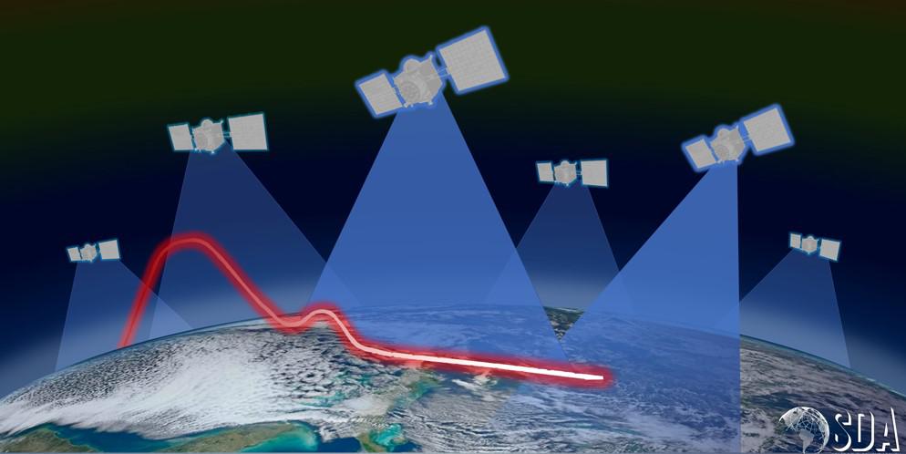
For the NDSA, a proliferated low-earth-orbit constellation of satellites and sensors will connect the U.S. military’s tactical legacy datalinks and weapons systems to deter against advanced threats, including hypersonic vehicles. It will provide beyond-line-of-sight targeting capabilities and the ability to detect, track and have fire control against advanced missile threats, according to Derek Tournear, director of the Space Development Agency (SDA).
The NDSA will also provide the space-based backbone for the military’s Joint all-domain command and control, or JADC2. The layers of the NDSA include transport, battle management, tracking, custody, deterrence, navigation and support. The agency has emphasized speed in getting the architecture in space and is rapidly deploying the first set of capabilities as part of Tranche Zero.
The SDA’s latest contract awards are for the tracking layer of the NDSA—two firm-fixed-price contracts of $194 million and $149 million, respectively, to L3Harris Technologies Inc., of Melbourne, Florida , and Space Exploration Technologies Corp. (Space X) of Hawthorne, California—which will provide detection and tracking of missiles through deployment of optical, wide-field-of-view satellites with overhead persistent infrared sensors (OPIR).
As part of Tranche Zero, the companies will each provide four wide field-of-view sensors to demonstrate the traceability that will be used for hypersonic glide vehicle detection over the entire globe, as well as for passing the data either directly to the ground or to the transport satellites.
The tracking layer is part of three sensing layers that will feed data to the NDSA’s transport layer. In addition to the OPIR sensors, the other sensing layers include a custody layer that would allow military users to send target location information in real time directly to weapons systems and a deterrence layer for space situational awareness, Tournear explained.
“The sensing satellites will detect the missile, send the track to the transport layer where that data could be fused with other data and then send [it] down to the ground to the actual weapon systems that would engage the threat,” he stated.
The agency is working with the Missile Defense Agency to fly the hypersonic ballistic tracking space sensor satellites, or HPTSS, “either one or two for what we call our medium field-of-view sensor,” Tournear said. “Our goal is that our wide field-of-view sensor will tip the medium field-of-view sensor and that sensor will allow us to actually even get more sensitivity and a better fire control solution for these hypersonic glide vehicles. And again, that data would then go either directly to the ground or to the ground via the transport satellites.”
The agency has already been pursuing the NDSA’s backbone transport layer, made up of hundreds of satellites in low-earth orbit that will all be optically connected to form a mesh network in space. As part of the first deployment of capabilities in the next year in Tranche Zero, the SDA will fly 20 transport satellites to form the network and enable communications to legacy tactical datalinks.
On August 31, the agency awarded Lockheed Martin Corp. of Littleton, Colorado a $187,542,461 firm-fixed-price contract and small business York Space Systems of Denver a $94,036,666 firm-fixed-price contract, to each provide 10 transport satellites as part of this backbone.
“In addition to being able to talk to each other, that data transport layer also can talk directly via existing tactical datalinks, such as Link 16, and down to weapons systems that are already fielded and already have that capability,” Tournear noted. “We are working very closely with the Army to ensure that we can talk from our transport satellites down to their TITAN ground system, so they could then further disseminate the data to other weapons systems that aren’t connected via Link 16. And we’re working with the Navy for similar systems to do that over their CEC comm channels.”
The agency is addressing capability gaps in the military’s space solutions, including providing space situational awareness in extended space to cislunar, between the Earth and the moon’s orbit.
“The architecture is focused on delivering the initial capabilities of beyond-line-of-sight targeting for time-sensitive targets, both ground and maritime,” Tournear stated. “We need to get that up there as rapidly as possible. And because more advanced missiles are being fielded [by adversaries], we need to have a space sensing layer that can detect, track and then set down fire control information to be able to take out those targets. So that’s what drives us. That’s why it’s important. We believe that these threats are in existence now, and we believe that we need the capabilities fielded as soon as we can.”


Comments