Hurricane Hunters Bravely Map the Course

A one-of-a-kind organization in the U.S. Department of Defense (DoD) has a dangerous mission: to fly in, through and out of hurricanes to better understand a storm’s path.
The 53rd Weather Reconnaissance Squadron (WRS)—the DoD’s “Hurricane Hunters”—is the only operational unit in the world to routinely fly weather reconnaissance.
The National Weather Reconnaissance program includes two parts: the National Oceanic and Atmospheric Administration (NOAA), which, through its Aircraft Operations Center performs primarily a research function, and the 53rd WRS, which has an operations mission. The NOAA conducts research on how to adjust future weather modeling capabilities, while the DoD Hurricane Hunters provide up-to-date data on a storm’s course. The squadron also provides vital weather reconnaissance during the winter.
Even more impressive is that the 53rd WRS is U.S. Air Force Reserve. The squadron is part of the Air Force Reserve 403rd Wing at Keesler Air Force Base, Mississippi. The 53rd WRS is seeing a great increase in demand for its operations, both for summer and winter weather reconnaissance, explained Maj. Chris Dyke, an aerial reconnaissance weather officer in the 53rd WRS, during a media briefing at Joint Base Andrews in April with several Hurricane Hunters and Maj. Gen. McCauley von Hoffman, deputy to the chief of the Air Force Reserve.
“While originally resourced as a six-month mission, our weather reconnaissance is now 10 months of every year,” Maj. Dyke noted.
In fiscal year 2023, the 53rd WRS saw the most operational flying hours than in the past nine years, and FY 24 is already meeting and exceeding FY 23’s hours.
For hurricanes, the squadron runs 24-hour operations and can fly three storms at a time out of three different locations. They deploy from Keesler; Kelly Field, Joint Base San Antonio-Lackland, Texas; Savannah Air National Guard Base, Georgia; Homestead Air Reserve Base, Florida; St. Croix, U.S. Virgin Islands; U.S. Forward Operating Locations, Curacao; and Barbers Point, Hawaii.
“Once we are turned on [for a storm], it’s 24/7 operations,” Maj. Dyke noted. “We are just constantly churning missions until the storm makes landfall. What we are doing is collecting data that is going into the model that’s actively running.”
The 53rd WRS has upgraded one of its key data collection tools, the GPS-based dropsonde system that measures atmospheric conditions, including temperature, dew point, pressure, wind speed and wind direction. In 2023, the squadron moved from using an older version called the RD-41 to a revamped nRD-41 dropsonde model, which offers efficiency, size, weight and power gains, explained Master Sgt. Shawn Hogue during an accompanying demonstration flight along the mid-Atlantic coast with the media and Gen. von Hoffman in April.
The nRD-41 dropsonde is smaller than a paper towel tube and includes a microchip, sensors, battery, radio transmitter, GPS antennas, receivers and a parachute.
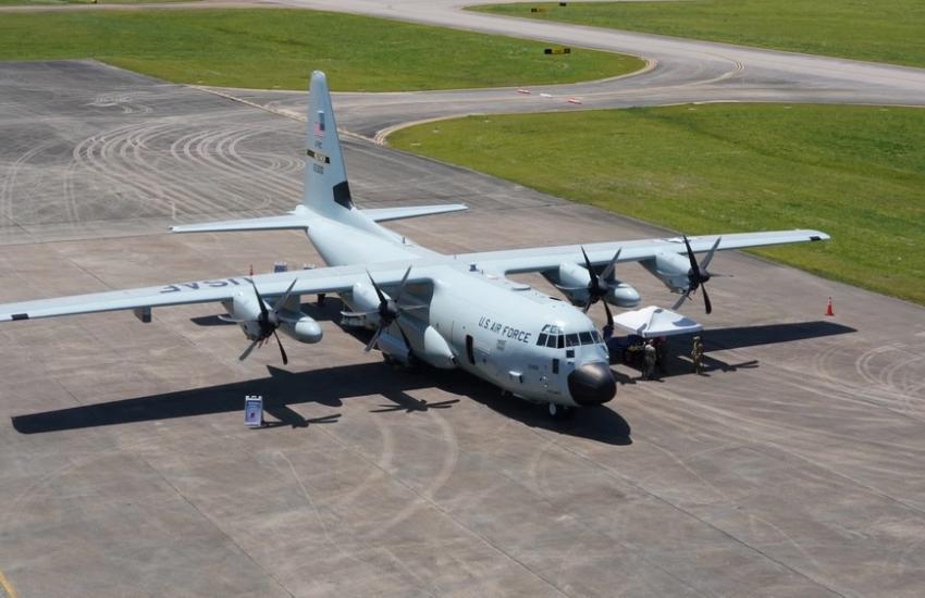
Collected data from the dropsondes are relayed directly to the Hurricane Hunters’ aircraft and to the National Hurricane Center in Miami, at two times a second. The Hurricane Hunters’ plane, WC-130J, is a weather version of a C-130 transport aircraft, and it has an internal pressurized launch tube that allows the loadmaster to release the dropsonde through the bottom of the fuselage during flight. The WC-130J also has a back bay door that opens under fairer conditions with manual disbursement of the sensor by the airmen. About 30-40 dropsondes could be released per flight, depending on the operations plan.
The dropsonde data from the heart of a storm enables more effective tracking and predictions for a storm’s path, with accuracy gains of hurricane predictions and warnings increasing by 20%. “In addition, sensing strategy tweaks have increased accuracy another 10-15% in our mesoscale models,” Dyke said. “It all adds value in forecaster immediate awareness [about a storm].” Typically, a storm can start as a tropical storm with a generally indicated path. The Hurricane Hunters data has been crucial in redefining a storm’s size, power, path and potential destruction.
In addition to the loadmaster, the orchestrated, agile Hurricane Hunters crew teams are made up of four other members: two C-130 pilots, one navigator and one aerial reconnaissance weather officer. The Air Force Reserve-owned mission features 10 full-time crews and 10 part-time crews.
Flying in such storms does take an iron stomach and adroitness of piloting. Hurricane Hunter pilots Lt. Col. Jesse Rosal and Lt. Col. Stephen Pituch have gotten used to it after flying many missions. The prop plane is remarkably steady despite the high winds and turbulence, although hail remains a major risk, they said.
During a hurricane mission, the pilots usually fly at an altitude of around 10,000 feet to collect the atmospheric data in the eye of the storm. Given the circular nature of storms, they fly a radius of about 105 miles from a hurricane’s eye to have a representative data collection, according to a report from the 403rd Wing.
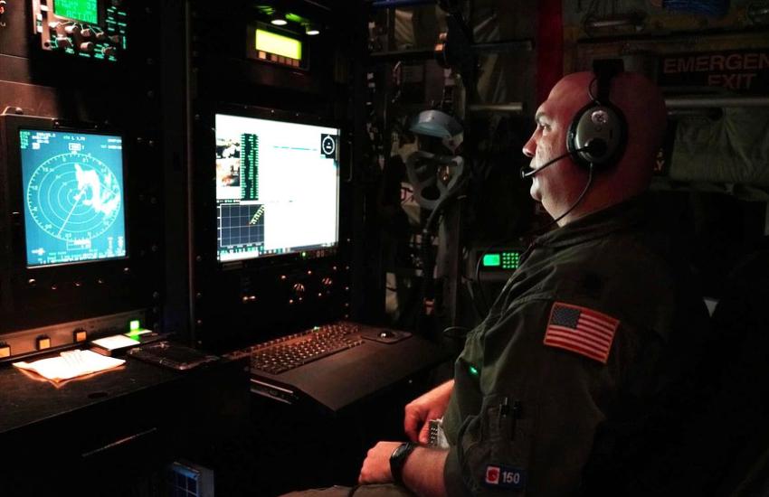
And while the pilots of course fly the aircraft, the aerial reconnaissance weather officer, with the navigator, directs the flight into and around the storm to fine-tune the data gathering.
In addition to the dropsondes, the Hurricane Hunters’ other current sensing capabilities include a hygrometer that measures humidity and dew points, ocean sensors and an APN-241 radar (typically used on the C-130) that, in this case, helps the teams understand a storm’s structure. Over time, the squadron has made upgrades to other systems on the planes, including radios and computers, very high frequency 3 systems, telemetry chassis, stepped frequency microwave radiometer software and the drop tubes, among other upgrades.
As far as a wish list of future technology from industry, Maj. Dyke shared that the squadron would love to possibly evaluate: nose radars; lidars; dual pol radars; small, unmanned aircraft systems; airborne expendable buoy processing systems; Doppler-based imaging wind and rain airborne profilers; and other technologies. In addition, the weather reconnaissance mission always needs better broadband access for increased data flows, improved Doppler radars to provide higher resolution data about storms and sensor pods that provide custom data to meet user needs.
For the already underway 2024 hurricane season, NOAA expected an “above-normal” amount of activity, with 17 to 25 total named storms in the Atlantic between June 1 and November 30, according to a May 24 report. The agency expects eight to 13 of those storms to become hurricanes with winds of 74 mph or higher and more than half of those coming as major hurricanes, Category 3, 4 or 5, and winds of 111 mph or higher. The agency reported the first named storm of the season, Tropical Storm Alberto, on June 19.
Now and always, the DoD’s Hurricane Hunters, U.S. Air Force Reservists, stand ready for the mission.


Comments