Emergency Situational Awareness Looks Ahead
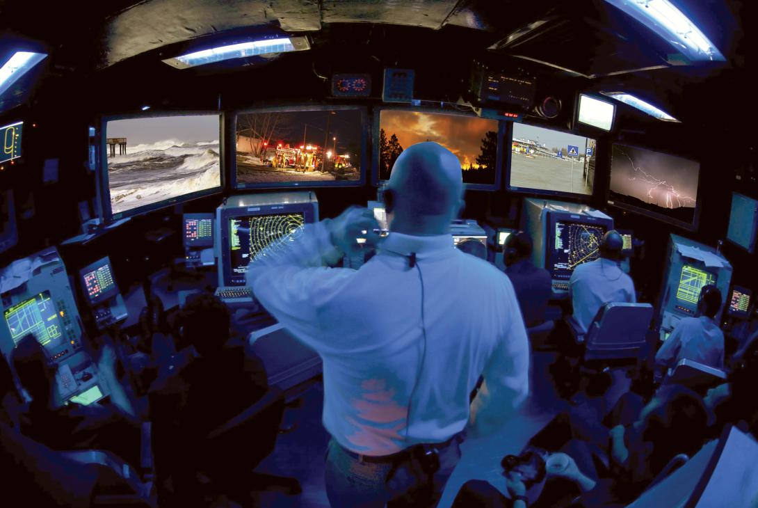
Emergency responders may be able to anticipate unfolding disasters before they have to respond, as a result of a new system that combines situational input with simulation. When floodwaters are rising or a fire is spewing toxic fumes, emergency personnel can simulate in real time how the threat might expand and evolve and plan their responses accordingly.
The system incorporates modules that allow it to simulate and predict how a disaster scenario might evolve. Different emergency response groups can use it to coordinate activities. With its situational awareness inputs, this permits responders to stay a step ahead of an unfolding disaster while ensuring an efficient, coordinated response during and after the emergency.
Known as the System for Advanced Field Emergency Operations, or SAFER, the system can be used by firefighters, police, armed forces and other rescue groups to view a common operational picture. Built by Tecmic, Porto Salvo, Portugal, SAFER already is in use in several locations throughout Portugal and is designed to be adapted to other nations’ requirements.
Joao Reis Barata, Tecmic’s CEO, explains that SAFER represents the evolution of an earlier system known as 4Forces. This technology monitored earth, air, fire and water to generate a common situational awareness picture. It provides vital information for decision-making when dealing with fires, earthquakes, toxic fumes, chemical spills into waterways or floods. Each threat requires a different type of response, Barata points out, and earthquakes and their aftershocks cannot be predicted.
SAFER integrates information for all these scenarios from diverse sources ranging from weather systems to field video cameras. This vital data is input automatically into SAFER, Barata says, and this eliminates the time-consuming task of inputting this data during an emergency.
“It’s not enough to have a weather station inputting data into a tool,” Barata explains. “You have to have a full model that will be the [product] of all the algorithms you program into the tool.”
Barata notes that varying situational awareness pictures used to hamper Portuguese emergency responders from different organizations. With several different groups each having a different presentation of the threat, they would take actions that did not take into account what their counterparts were doing. SAFER minimizes that problem, he offers, and adds a common evolutionary threat picture.
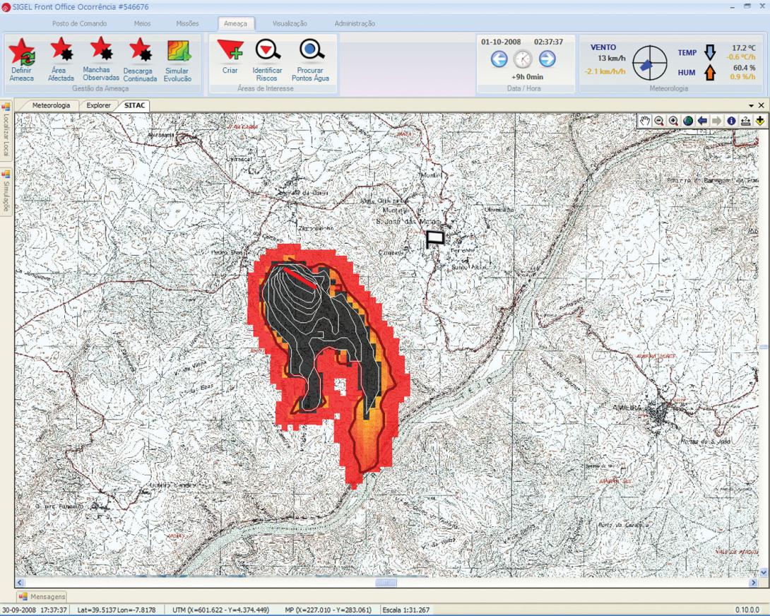
SAFER can generate several models of threat evolution, depending on the nature of the threat, Barata says. It takes into account the geographic landscape, wind speeds, humidity, soil type, water currents in rivers or the sea and the overall weather forecast. In fighting brush or forest fires, video cameras equipped with position location systems and lasers can track fires and input their data automatically into the system.
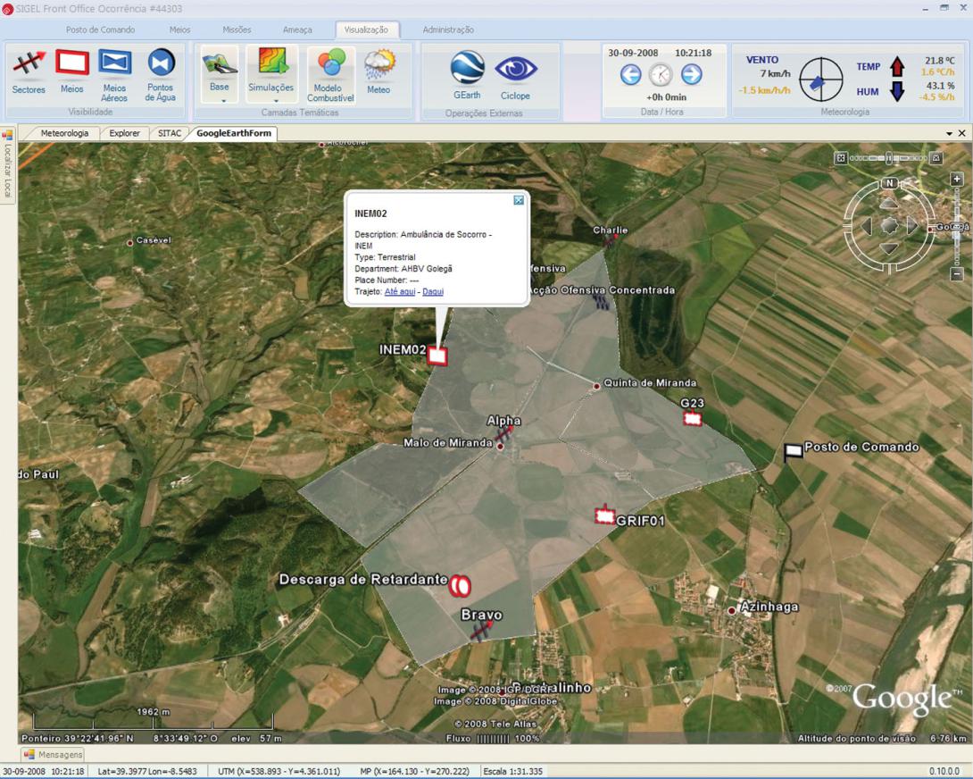
Barata relates that emergency responders cited logistics as a key aspect of effective response. SAFER consolidates information such as available resources and how many hours in the field people were working without any rest. Knowing how much support an operation needs—even down to food and water for the responders—is a vital capability that SAFER provides, he says.
Forces can integrate while maintaining their separate processes, Barata points out. Each force’s commander can direct each individual element while drawing from a common situational awareness picture that illustrates what each group is doing and where it is positioned. And, each element can opt to produce its own picture that is tailored to its specific mission. If a group realizes it cannot render vital assistance in one particular area, it can view which group is positioned and equipped to step in to help and request assistance from it.
The key to SAFER’s effectiveness is its suite of algorithms that allows the consolidation of the data along with the simulation of the evolving threat. The system is designed to track and forecast spread patterns for fires, toxic liquid spills, poison gas releases, floods, oceanic oil spills or radioactive gas releases. Each of these threats behaves differently than the others, and this required specific algorithms for each threat. To meet this challenge, Barata relates, his company worked with local universities. These partnerships resulted in several algorithms for simulating different types of threats, he notes.
At the heart of SAFER are the modules that focus on different scenarios. One module that focuses on urban and river flooding incorporates a user-friendly graphical interface to enable predictions of flooding evolution over several hours. It combines existing and forecast weather information along with other data such as ground moisture content and tidal conditions.
Another module enables a virtual emergency simulator that can be used to train responders to handle any of a number of potential scenarios that might arise. Trainees learning to fight a wildfire, for example, can have gale-force winds thrown into the simulation to test their reaction to the suddenly changing situation. Firefighters in urban areas can be confronted with blocked streets or collapsing buildings, among other possibilities.
Vital signs of emergency service personnel in the field could be monitored by a module that incorporates data from a smart jacket worn by responders. This jacket contains an electrocardiogram monitor, temperature sensors and a GPS receiver all linked to a smartphone to the command center via a mobile data connection.
Another module addresses a less rewarding activity by simulating the drift of a corpse in water. It takes into account current and tidal data, the time of immersion and whether or not the person was alive. This module can help recover the body by projecting, on a digital map, the probability of it being located in a particular area.
Portugal has a fire detection surveillance system that works automatically, Barata observes. An interface allows a SAFER operator to gain control of its cameras to see what they are viewing, if necessary. These cameras, which are equipped with lasers, can provide information on the fire’s distance from the lens. Multiple cameras provide a three-dimensional plot of the fire’s location. With this data input automatically into the system along with other environmental data, a SAFER simulation can predict where a wildfire might be heading over the next several hours.
In addition to facing varying threats, responders must deal with communications that often differ among sensors and responding groups. This mandates a decentralized communications system in which some participants may lose communications. SAFER is designed to function under degraded conditions, which Barata describes as a major challenge that was overcome with assistance from emergency responders.
This technology can change the way authorities respond to an emergency, Barata avows, and it already is happening among some of its users. But the capabilities it brings will require significant changes in processes and procedures. Decades-old traditional approaches must be abandoned, and this represents a major cultural shift. Users must undergo substantial training to be able to take advantage of the system to its fullest.
Even with SAFER’s limited deployment, upgrades are in the works. Designers are looking at improving how data inputs are introduced into the system. For example, flood prediction can rely on knowing how much rain will fall in the next couple of hours. This will require refining the models for weather forecasting. Barata relates that designers are looking at using government weather radar images to determine how much humidity is in the air, which would aid rainfall predictions. Successful simulations could lead to organized targeted evacuations well before waters rise to dangerous levels, he points out.
Another upgrade would address a worst-case scenario by building on the existing body recovery capability. Despite the best efforts of responders and rescuers, some disasters result in a significant death toll. When storms or tsunamis result in widespread deaths, recovery personnel often may require several days to determine where victims have been carried off by river flows or ocean currents. Engineers are trying to expand SAFER’s current and flow models to be able to locate large numbers of bodies swept away by a water tragedy.
SAFER already is in use in a few provinces in Portugal, Barata says, but its use is not as widespread as it should be. The system came of age right when Portugal’s financial crisis was raging, and government spending cutbacks were endemic. Not as many communities could purchase SAFER in this austere belt-tightening environment, he relates, as their spending priorities were directed toward immediately visible assets such as firefighting vehicles and aircraft.
Barata offers that the best course of action would be for SAFER to be procured among all of Portugal’s provinces. That way, when large-scale disasters unfolded, all of the neighboring provinces involved in responding could operate from the same situational awareness picture based on the same simulation. With traditional systems, neighboring responders often find it difficult to coordinate efforts. A nationwide implementation would provide much greater flexibility for considering far-reaching alternatives.
SAFER transitions to other nations’ emergency response systems as well, Barata maintains. With the Portuguese market being extremely limited in size, the system was designed to be exportable to other nations. Designers had to ensure that weather forecasts could be introduced into the system in whichever country it was used, and other inputs from several nations also can be incorporated. Where necessary, interfaces enable full operation with other surveillance systems, for example.

Comments