Budget-Constrained UN Space Group Welcomes Industry Partnerships for Disaster Preparedness
Editor's Note: This article was modified October 17, 2025.
What began as a pilot program has evolved into an emerging technology investment for disaster management and preparedness in nations with limited resources. A project initiated by the United Nations Office for Outer Space Affairs, or UNOOSA, is making room for further partnerships with the private sector to collect, supply and enhance data through the use of artificial intelligence (AI) and machine learning (ML).
Digital twins are data-based virtual models of physical objects or places. Today’s digital twin technology is often interactive and used for simulations. With the addition of emerging technologies such as AI and ML, the potential for a much more advanced capability evolves.
For Lóránt Czárán, a self-identified AI skeptic, the possibilities of the technology for the betterment of the world are worth looking into.
Czárán, a geographer by trade, joined the U.N. in 1996 and has never looked back. “I’m one of those dinosaurs that spent time in seven different organizations,” he joked during a conversation with SIGNAL Media.
Today, Czárán serves as the head of the U.N. Platform for Space-based Information for Disaster Management and Emergency Response, commonly known as UN-SPIDER. Established in 2006, the program is under the umbrella of UNOOSA.
“It was the most attractive and sexy U.N. project that you could think of, matching space technology with disaster management,” he stated.
One of the most recently announced initiatives by the group has been the launch of digital twins developed by Japanese-based SpaceData Inc., with data supplied by Maxar Technologies Inc., and Airbus. The project is also done in collaboration with the Committee on Earth Observation Satellites, also known as CEOS.
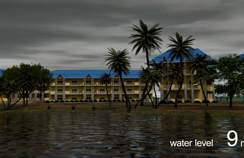
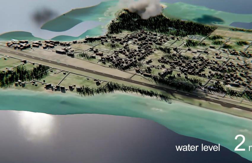
Through the use of high-resolution satellite imagery, small island developing states now have access to potentially life-saving data.
Digital twin capability for disaster management is not a novel concept. Following the 2018 Category 5 Hurricane Michael, which passed over Tyndall Air Force Base and caused $5 billion in damage, Booz Allen and Unity collaborated on a digital twin project. “From its infrastructure and landscape to its systems and processes, the Tyndall digital twin stays in step with the physical world through a digital thread that links authoritative data sources like enterprise data systems and building information model updates,” a case study reveals. “Tyndall is relying on its enterprise-scale digital twin to protect assets from natural disaster and ramp up flightline operations for the F-35A Lightning II aircraft—all in an agile, scalable and human-centered environment that updates in real-time.”
Tyndall is just one example of the capability’s use case. For UNOOSA, resources are scarce, meaning limited access to modern technology and less funding.
“It started in Tonga,” Czárán shared. “When visiting the country, we realized that they have very little in their hands to be prepared against the almost daily earthquakes that happen, the tsunami risks, the sea level rise risk, and everything that’s going on on an island that’s within two meters of the sea level.”
Tonga, a member of more than 170 South Pacific islands, has a surface area of approximately 290 square miles, with a 2024 World Bank-reported population of just over 100,000 people.
While a 2011 mission to Tonga was unsuccessful due to a lack of resources, additional funding from the People’s Republic of China allowed the UN-SPIDER team to revisit the topic in December 2023.
“I decided to organize a regional workshop in Fiji to bring together disaster measures from most of the island states,” Czárán said. “We brought 26 [representatives] from 11 island states for a week.”
During that meeting, the Tonga representative invited all attendees to visit his country for a follow-up to the fruitless 2011 mission. Quick on their feet, the team flew to the island for two-day discussions with the nation’s disaster management entity.
“[We] discovered that they have good GIS [geographic information systems] people there, remote sensing experts … young, enthusiastic people,” Czárán shared. “All they lack is access to data.”
Notably, the 2022 volcanic eruption and subsequent 66-foot tsunami caused more than $182 million in damage in Tonga, according to a World Bank report. The use of end-to-end warning systems and early warning protocols has been in place since a destructive 2009 tsunami, keeping the death toll at four people.
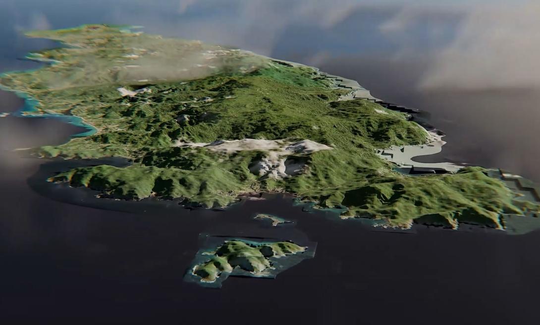
“A lot of their tourism was wiped out,” Czárán said. “We said, for an island like this, probably the first thing you can do is a digital twin, a very detailed 3D model of what you have here.”
Aiming to have the pilot project ready to present at the August 2024 Pacific Islands Forum, the UN-SPIDER team set out an ambitious timeline and operation.
The forum, which annually brings together representatives from 18 countries and territories—including Australia and New Zealand—was an opportunity for Czárán and his team to showcase the value of Earth observation capabilities.
“People are not convinced that this data and these kinds of technologies are of high value, especially in small islands,” he said.
Thus, in just under four months, from January to April 2024, the Tonga digital twin was developed and readily presented at the August forum. Along with that meeting, UN-SPIDER also launched a Tonga disaster preparedness platform with all the available data.
“This all took just a few months to put together at no cost to [Tonga],” Czárán stated.
While the number of companies offering digital twin capabilities has exponentially grown in recent years, Japanese startup SpaceData Inc., particularly stood out to Czárán.
“Airbus provided the data and the digital elevation model as a donation; SpaceData did all the job, the fusing, the development of the 3D digital twin,” Czárán said, specifically noting SpaceData’s use of AI to deliver in record time.
Established in 2017, SpaceData Inc., was founded by Katsuaki Sato, a young entrepreneur who was named one of “Top 10 Entrepreneurs to Save Japan” by Forbes Japan. Sato’s goal was to integrate AI tools into space-based data for digital twin generation.
The company, which has developed automatically generated data for the well-known Fortnite game, has grown through partnerships with the Japanese government and initiatives like the one led by UN-SPIDER.
In addition to creating digital twins and flood simulations for the U.N. group, SpaceData is also using its capabilities to create digital twins of large cities and even the International Space Station.
Although the technology heavily relies on AI capability, a human must remain in the loop, said Atsushi Takata, executive officer for global business at SpaceData Inc.
Takata joined the company in 2024 following his work at Kanematsu Corporation, where he led a partnership with Sierra Space.
“Approximately three-fourths of our team are engineers and creators, and right now we have 100 members on the team,” Takata told SIGNAL Media in an interview. In terms of the amount of time it takes to develop digital twins, Takata said the answer is not one size fits all.
“It really depends on the area and the regions, how big it is, because there is some work we are monitoring by hand,” he explained. “For the AI and the imagery side, we can generate very quickly, like a day or two, for basic ground situation using our AI technologies, but it’s not super precise, so we need some modification. That’s why it’s going to take at least a month to create a very high-resolution field.”
The company is currently researching an entirely AI-generated process through a small business innovation research contract with the Japanese government, Takata shared.
Regarding the digital twins created for Tonga, and later also for Ghana and the island of Tobago, Takata spoke on the company’s incentive to work with UNOOSA.
“We already have the pipelines that can generate revenue from different customers, and our vision is always ... do something very beneficial for life on Earth,” he said. “We think the U.N.’s activity is very important, especially to empower the people who don’t have access to space or use space capability.”
For the collaboration, Takata largely credits his friend and colleague Jumpei Takami, who currently serves as associate expert in remote sensing for disaster management at UN-SPIDER. Takami holds a Master of Science in civil engineering from the University of Washington. His interest in emerging technology has allowed him to explore applying ML tools for disaster preparedness and climate resilience.
During the SpaceData Inc., interview, which Takami joined, he spoke on the importance of such collaboration with the private sector, a point echoed by Czárán.
Over time, the U.N. has welcomed partnerships with the private sector, Czárán explained. In the space environment where private sector companies are increasingly dominating, leveraging their work and data is a game-changer, he continued.
“For us at UNOOSA, it’s even more important to have a stronger relationship with the private sector ... if they are willing to provide resources, we should be happy to take them,” he stressed.
Regarding the digital twins initiative, Czárán spoke on the memorandum of understanding (MOU) process in place for industry partnerships.
While SpaceData Inc., took charge of fusing and developing the flood simulations, the high-resolution imagery was offered by Maxar and Airbus.
“These are based on MOUs that took us a long time to develop, and in some cases also some commercial contracts for companies that provide us data, so we have certain so-called U.N. system contracts with Maxar and Airbus, which allows everybody in the U.N. system to easily purchase satellite imagery, without going through these painful three-month procurement exercises that are typical in the U.N.,” Czárán said.
Noting UNOOSA’s mission to reduce barriers to access space-based data—including Earth observation, digital elevation models and satellite communications coverage for disaster management and response—Airbus’ Ciro Daragiati Farinelli commented on the importance of such partnerships.
“We recognized a strong alignment between this mission and our own values,” he told SIGNAL Media in an email. “In 2019, we signed [an MOU] with UNOOSA ... to share radar Earth observation data from the German DLR TerraSAR-X mission for regions impacted by natural disasters, such as earthquakes and floods,” he stated.
The data, made available to UN-SPIDER, provided information for not only immediate disaster response, but also for the development of local expertise in analyzing space data, particularly in emerging nations. “Over time, this contributes to greater resilience and self-sufficiency in using space-based technologies for humanitarian and environmental needs,” Farinelli shared.
“To me, industry would be key going forward, especially in outer space. There’s no way we can work without them,” Czárán stressed.
Most recently, he shared, Czárán’s office has submitted a proposal for digital twin generation for an additional 100 islands over a year. If approved and funded, the U.N. veteran says he hopes to continue working with SpaceData and other companies wanting to make a difference.
Comments