Critical Need Pushes Prototypes Into Afghanistan
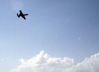 |
Prototype communications systems being fielded in the eastern region of Afghanistan allow aircraft crews to know where friendly dismounted troops are located. |
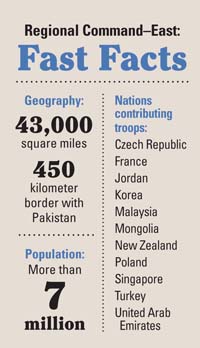
Necessity may be the mother of invention, but in Afghanistan’s eastern region, the need to connect dismounted soldiers to the network has prompted a mother lode of innovation. The forbidding area is unlike any other part of Afghanistan, according to U.S. Army officials. With mountains more than 20,000 feet high, much of the tough terrain is not traversable with ground vehicles, making dismounted operations a must in the area. Connecting those dismounted troops to the network is a critical necessity, which is why Army officials are experimenting with a host of prototypes designed to put dismounted soldiers on the digital map. Those systems include the Distributed Tactical Communications System, the Broadband Global Area Network satellite terminal and the Panther satellite communications system.
Most of today’s military communications systems are designed to be mounted inside vehicles, explains Lt. Col. Joseph Hilfiker, USA, former communications director for Regional Command–East (RC-East). But dismounted soldiers in the area must go where no ground vehicle has gone before. In fact, many helicopters cannot reach some of the mountaintops, which has given the 1960s-era Chinook a new lease on life. Chinooks are used to ferry dismounted formations around the hostile terrain. “There are no vehicles up there. Never will be any vehicles up there. Not in our lifetime,” Col. Hilfiker asserts.
Line-of-sight systems are also of little use in mountainous terrain, so soldiers in the eastern region need easy-to-carry, beyond-line-of-sight communications equipment. To integrate dismounted formations into the common operational picture, essentially creating an icon on the digital map for foot soldiers, Col. Hilfiker and his band of innovators have been working with industry to tweak some prototypical systems. For example, the Distributed Tactical Communications System (DTCS), which is developed by ITT Defense and Information Solutions, McLean, Virginia, uses the Iridium satellite signal to offer an encrypted, on-the-move, omnidirectional capability.
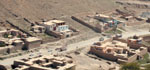 |
| Taken from an Apache helicopter between Kabul and Bagram, this photo depicts some of the harsh, mountainous terrain in Afghanistan. Because much of the eastern region is not accessible to ground vehicles, dismounted operations are a must, and reliable communications for dismounted soldiers is a critical need. |
The next step is to integrate a personal digital assistant to DTCS so that key leaders could send text messages to other DTCS clients. That capability would enable texting between platoon leaders and their company commanders and between company and battalion commanders. It also would provide DTCS radios with the capability to use text to call for fires, request medevacs and perform other essential tasks, the lieutenant colonel explains.
Newer versions of DTCS also contain a digital map, and every DTCS radio can locate every other DTCS radio, enhancing situational awareness even further. “A company commander sitting out there on a hilltop with three platoons on maneuvers can see where every one of his platoons and his squads are. So, now we are talking about a two-way situational awareness capability,” he says. RC-East officials have fielded one prototype and sent ideas back to ITT, where the system will be tweaked and sent back to Afghanistan for further testing. “That’s going to give us a two-way data capability down to the squad, platoon and company level,” Col. Hilfiker forecasts.
In addition to DTCS, Army officials are using the Harris Broadband Global Area Network (BGAN) satellite terminal, which offers satellite voice and wideband data capabilities with just enough of a data rate to enable chat, according to the lieutenant colonel. The idea is that the platoon leader or company commander, when they are at a quick halt, can hook up the BGAN to a Harris 117 radio and have the ability to chat, Col. Hilfiker explains. “We’re not going to field [BGAN] to every platoon because they’re too expensive, but what we’re going to do is field them to every brigade so that they will have a capability to use these for certain operations.”
The third prototype, the L-3 Communications Panther manpack very small aperture terminal satellite communications system, is about the size of a small suitcase, Col. Hilfiker estimates, but with the batteries and accessories, it is probably a “two-man carry.”
Because the systems are prototypes, they are donated mostly in small numbers to units in Afghanistan. Forces in RC-East have had no problem with resources so far, but if they wanted to field these systems to every squad, “We’d probably have to go back to Congress,” according to Col. Hilfiker.
 |
Powering systems for dismounted troops still requires that soldiers be loaded down with batteries. While forces in the eastern region have experimented with fuel cells, they have found the technology so far is too cumbersome to offer significant advantages.
Although it is not one of his projects, Col. Hilfiker reveals that NATO plans to provide Afghanistan National Security Forces with a DTCS-like Afghan Force Tracker, which would provide an icon on the digital map for those forces as well. Fielding is expected to begin this year, but has already been delayed several times. “This is Afghanistan. Everything’s hard,” he says.
One advantage of working with prototype systems is that they are less entangled in red tape than so-called programs of record. “All of this is done in theater—research and development in theater. All the stuff we’re doing with DTCS, frankly if it was a program of record, there would be people lining up to tell us we can’t do it. There are too many rules,” Col. Hilfiker states.
He also discounts the notion that having these capabilities in RC-East might create interoperability problems with forces in the other regions. For one thing, very few operations require forces from different regions to work together, and on those rare occasions when they do, the prototype systems are just another added capability RC-East can bring to the battle, he explains.
As units rotate in and out of RC-East, they transfer new technologies and lessons learned, each unit passing along a legacy that could impact dismounted soldiers well into the future. Extending the network and putting icons on the screen for dismounted soldiers improves situational awareness, enhances mission success and minimizes fratricide. “All of this is about extending the network down to the dismounted soldier, the dismounted squad. If you’ve got an F-16 or a B-52 flying at 52,000 feet, you can’t always tell who’s who on the ground during a fight. But if you’ve got a DTCS radio with that rifle platoon that’s in contact with the enemy, you know where your friendly forces are,” Col. Hilfiker says.
WEB RESOURCES
RC-East: www.isaf.nato.int/subordinate-commands/rc-east/index.php
101st Airborne Division Screaming Eagles: www.campbell.army.mil/units/101st/Pages/default.aspx


Comments