Military Users Boost Commercial Imagery
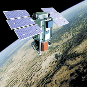 |
DigitalGlobe's QuickBird satellite provides commercial remote sensing panchromatic imagery with a resolution of 0.61 meters. The next generation of commercial remote sensing satellites, which is the target of the National Geospatial-Intelligence Agency's NextView program, will have a panchromatic resolution at least as sharp as 0.5 meters. |
The National Geospatial-Intelligence Agency is taking direct action in the commercial remote sensing marketplace with a five-year funding commitment to ensure the next generation of orbiting imagers. Acknowledging the vital role played by commercial remote sensing satellites, the government agency seeks both to guarantee that these next-generation orbiters will be built and to influence their design to suit agency customers.
This commitment begins with a five-year, $500 million contract to DigitalGlobe Incorporated, Longmont, Colorado. Negotiations continue with another commercial satellite imaging firm as the agency pursues its goal of ensuring that 0.5-meter-resolution orbiters are on station before the current constellation of satellites runs its course.
This program, known as NextView, is tied to commercial remote sensing policies established by the White House and the Central Intelligence Agency, according to National Geospatial-Intelligence Agency (NGA) officials. The contract covers areas ranging from technology development to imagery acquisition.
“This is a critical element with respect to reinforcing the partnership that we have with the private sector,” states Roberta Lenczowski, NGA’s technical executive.
NGA (formerly the National Imagery and Mapping Agency) would want the new capabilities to be available on orbit sometime in 2006, notes Jaan A. Loger, NGA’s acquisition executive. “We are not in the satellite-building business—we are in the business of buying imagery,” he emphasizes. “We are interested in making sure the imagery is available in that time frame.
“We are investing in the ability to buy the imagery in 2006 and beyond,” he says. “The biggest thing that we want is not a technology issue. It is that we want to ensure that there is another generation of U.S. commercial imaging from space.”
The NextView contract covers several aspects of commercial remote sensing imagery acquisition in addition to resolution: assured access, priority tasking rights, area coverage and broad licensing terms. NGA wants to be able to acquire the imagery, access it from company archives and provide value-added services. Details of many of these issues are still being negotiated with a goal of completion over the next few months, NGA officials note.
The broad licensing capability addresses logistical snags that emerged with traditional licensing approaches. Originally, NGA used to purchase commercial imagery under a tiered arrangement. The original purchase was for a U.S. Defense Department customer, but as the imagery was shared with other customers, NGA would pay additional premiums. The more recent ClearView contract for buying imagery from existing on-orbit assets incorporated a single-tier license that gave the agency broad sharing capabilities. NextView will broaden the ClearView licensing capability to remove restrictions on how imagery can be used with coalition partners, nongovernmental organizations and state and local governments, for example.
NGA examined its requirements for standard geospatial products to determine its commercial remote sensing needs, Lenczowski offers. “The objective is to satisfy as many of those geospatial requirements as we can with commercial imagery, and the emphasis here is our need to purchase imagery,” she states. “The requirements that we levied in our request for proposal are based upon our needs for imagery of a certain resolution, certain accuracy, certain delivery times, total access and with broad licensing capability. How the contractors propose to respond to that can meet or exceed those requirements,” she emphasizes.
Influencing the development and construction of the next generation of commercial remote sensing satellites is the purpose of the NextView procurement, Loger states. And, the most important influencing activity is to ensure that this new generation exists by being “the anchor tenant or anchor customer,” he says. “We don’t expect to be the only investor; we only want to make sure that the world knows—and in particular the company knows—that we want that kind of product three years from now.”
However, the government agency is not micromanaging the design of this future satellite. NGA has given DigitalGlobe its capability parameters for the next-generation satellite, but it is not issuing specifications for construction, Loger emphasizes.
The only hard and fast design specification is that the satellite provide 0.5-meter panchromatic resolution, Loger says. For example, NGA is not issuing any requirements for satellite hardening, he notes.
“We have a set of threshold needs that we want based on the minimum we could stand. The minimum mostly is at least as good as we can do today, with the exception of resolution. Everything else is a ‘gray scale’ judgment in that we have objectives, but if they don’t make the objectives, it isn’t a [deal breaker],” he relates. “Whatever technologies [the commercial satellite company] applies to the scene have not been a major consideration for us—as long as they make the parameters equal to or better than what you have now.”
Lenczowski observes that the commercial remote sensing companies, when they discuss future technologies, tend to focus on better resolution, an improved collection capacity and more frequent revisits over a footprint on the Earth’s surface. “Those are their own technology objectives with respect to their next generation, and those are steps beyond what NGA receives today with their current assets,” she emphasizes.
Global access—being able to take pictures anywhere in the world—is a NGA requirement, but this is more of a prioritization of company assets than one of technical detail, Loger observes. The satellite also must be able to handle a certain amount of images and area each day. The agency is not looking for a quantum increase in volume capability. Yet, Lenczowski offers that the agency “would expect that the next generation of collectors would have the opportunity to provide additional collection in terms of the number of collection minutes per orbit.”
Lenczowski adds that timeliness is a requirement, as is quality of accuracy—knowing exactly where the imaged area is on Earth. She elaborates that these accuracies can entail understanding the parameters of the collection as well as post-processing. “The accuracy of the imagery used is a function of the accuracy of the products provided,” she says, which is vital for mapping accuracy.
Loger relates that DigitalGlobe showed NGA its plans for the next-generation satellite in the course of the company’s NextView proposal. This included the satellite’s design, how and where it would be built and its planned performance. He emphasizes that these were the company’s schedule and performance parameters, not NGA’s.
The fact that the commercial remote sensing companies are planning satellites that largely meet NGA’s requirements begs the question of why the government agency needs to fund their development. Loger addresses that point with a caution about the companies being able to carry out these plans.
“We are trying to address what we consider a weakness in industry at the moment—there has not been significant progress in the next-generation commercial remote sensing satellite,” Loger states. “Although the vendors have been looking at their next generation, they have not been able to commit to it yet.
“They are still a transient early marketplace that has not fully filled its expectations,” he observes. “We have not been seeing a vigorous commitment to getting on with it for the next generation. They have been looking at it; they have been studying it; they have been discussing it with their technology vendor providers; but we have not seen an active program that has a date by which they were intending to launch.
“We were looking at the current seasoning of the commercial remote sensing satellites we have on orbit, and in a few years they are going to get rather long in the tooth,” he relates. “We were concerned about that, and we were concerned about the fact that nobody was working on the next-generation capability with better resolution—which is what we think we need in the long run.
“So to us, we feel we have a commercial imagery gap that we consider very serious. That is the reason that we would seriously consider the investment approach to doing this—because if we try to wait around, it could be a finite possibility that there would be no one to do anything because they couldn’t get access to the capital to build the next-generation systems,” he emphasizes.
This would seriously affect NGA’s ability to carry out its mission, because the agency has been relying on commercial suppliers to an increasing degree. “We are increasingly using commercial imagery products, and we don’t want to be at a point a couple of years downstream where we could not buy that product anymore,” Loger warns.
The key noncost factors that the agency took into consideration for its NextView award were business case, schedule, technical approach, management approach and programmatic risk issues. The agency incorporated input from its customers through an existing process that collects customer requirements. Lenczowski relates that the NextView contract activity was based on understanding current need and projecting it into the time frame of the expected launch and on-orbit availability of the next generation of orbiters.
NGA already has plans for improving its electronic connection with the commercial imagery provider. These plans call for a more Web-like operation, and the NextView effort will improve on that approach.
There are two areas of NextView where NGA must be careful, Loger offers. One is the potential for satellite failure, either in launch or orbit. The other challenge involves whether the market will grow sufficiently to enable the industry to become truly self-sustaining. This would reduce the importance of the government marketplace and enhance the chances of success for the subsequent generation of orbiters. “There are business challenges, and there is the old-fashioned technical challenge of whether you can make it go,” he declares.
The agency continues to pursue negotiations with Space Imaging LLC, Thornton, Colorado, to ensure the continued development of that company’s follow-on system, Loger states. One potential snag in that effort is that the agency does not have the money to support two companies. However, it is “pursuing all possible avenues” to ensure the existence of two commercial imagery providers, Loger adds.


Comments