Radar Counters Camouflage
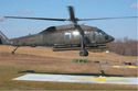 |
| An Army Night Vision Laboratory Black Hawk helicopter with an extra 10 inches ground clearance carries the Foliage Penetration (FOPEN) Reconnaissance, Surveillance, Tracking and Engagement Radar (FORESTER) during sensor flight tests. The radar, which can pinpoint troops and vehicles moving under trees, is slated for use on the A160 Hummingbird unmanned helicopter. |
An airborne sensor system that provides standoff and persistent wide-area surveillance of dismounted troops and vehicles moving through foliage holds the potential to change the scope of warfare. Mounting this sensor beneath an unmanned helicopter would enable identification of possible ambush sites. This small radar also denies concealment and sanctuary to enemy units hiding in wooded areas or moving in the open during darkness or adverse weather.
The Defense Advanced Research Projects Agency (DARPA) Information Exploitation Office (IXO) is developing the Foliage Penetration (FOPEN) Reconnaissance, Surveillance, Tracking and Engagement Radar, or FORESTER. The sensor is designed to detect and track moving dismounted soldiers and vehicles at a range of 30 kilometers (20 miles). The ground moving target indicator (GMTI) radar also can locate and track people in the open or through light foliage at a range of at least 50 kilometers (30 miles).
FORESTER’s program manager, Lyndall Beamer, explains that the ultrahigh frequency (UHF) synthetic aperture radar imagery resolution is 6 meters with a swath width of at least 5 kilometers (3 miles). “The sensor’s waveform agility and flexibility also enable the system to operate without undue interference to other users of the spectrum,” he states. “Employing the sensor system on the DARPA/U.S. Army A160 Hummingbird unmanned aerial vehicle [UAV] helicopter or other suitable platform will provide a robust, wide-area, all-weather, standoff capability.
“Filling a surveillance gap that currently exists, FORESTER’S capability is particularly important to the
The sensor package has been installed and flown successfully on an Army Black Hawk helicopter to demonstrate real-time detection and tracking of dismounted troops and vehicles. FORESTER subsequently will be flown on the A160 to detect and track slow-moving, low radar cross-section targets. An enemy in the field is certain to seek cover and concealment, making it critical for
Beamer’s background before his DARPA program manager assignment was in the intelligence community. Among other duties, he was responsible for drafting U.S. Defense Department planning guidance on intelligence, space, command and control and special operations mission areas. He also was chief of the strategic concept division, Defense Intelligence Agency, deputy for the Office of Collection Planning, and assistant for special operations intelligence. With a bachelor of arts degree from
The ability to find targets on the move and to strip them of concealment will have profound implications for commanders in maintaining constant total situational awareness, Beamer reports. Using a rotary-wing UAV, such as the Hummingbird, would enable determining minimum detectable target velocity with the system’s low frequency radar, exposing targets on the move and confirming enemy presence below the trees prior to weapons release.
A foliage penetration radar can locate a large class of targets that includes hidden tanks, mobile surface-to-air missiles, rocket artillery systems, supply vehicles and hidden operating bases. Beamer notes that the program started before his arrival. “We want to take this system and create an opportunity for our forces to accomplish what has previously been impossible. What would have happened, as an example, if we had a system like this during the Vietnam War? The technology could dramatically have changed the strategic focus of that war, especially along the Ho Chi Minh trail. The massive flow of troops, weapons and supplies down the trail could have been targeted and halted. The foliage penetration capability can shift the way a war is fought, forcing an enemy to hunker down.”
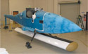 |
| The FORESTER radar system is installed in the A160 Hummingbird aircraft for fit check. Note the sensor’s antenna mounted beneath the aircraft. With the landing gear retracted and the aircraft in position over a reconnaissance area, the antenna rotates 90 degrees to a horizontal position to scan a 250-kilometer area every 40 seconds to 50 seconds for hidden enemy soldiers and vehicles. |
“The idea is to fly the UAV helicopter into the wind. If the wind is 50 miles an hour, we fly at the same speed to essentially hover over a target area. A mast interface bracket mechanically rotates the radar antenna into a horizontal position much like an aircraft wing, to electronically scan the radar—plus or minus 45 degrees—over an area of interest. This 90-degree total scan when flying at a 20,000-foot altitude, as an example, covers a 250-kilometer [155-mile] area every 40 to 50 seconds. This area can be revisited again with the radar in less than a minute,” Beamer explains.
The radar system functions in real time, passing surveillance data over a Ku-band datalink to a groundstation. Response can be immediate whenever targets are located. FORESTER’s UHF radar operates in P band, penetrating foliage very well and is unaffected by obscurants such as snow and particulates, Beamer insists. “We can put enough energy on a target area to find what we are looking for.
“The program is still in a crawl-walk-run mode of development, and we took a small version of the sensor system to Redstone Arsenal,
The radar is mounted beneath an Army Night Vision Laboratory Black Hawk helicopter, which has an extra 10 inches of ground clearance, for flight tests. After the Black Hawk tests, engineers plan to fly the radar on the A160 UAV. With DARPA/Army advocacy, Beamer’s plan is to fly the FORESTER on the Hummingbird later this year. “We started flying on the Black Hawk in January, anticipating approximately 30 flights to evaluate and measure system performance, validating software robustness and reliability,” he relates.
The helicopter’s constant vibration, rattle and jitter pose a difficult environment for any sensor, and “DARPA magic similar to gimbals was employed for motion compensation,” Beamer adds. “We proved the heliborne sensor could locate people moving on the ground. The demonstrations will continue with progressively more difficult scenarios. Black Hawk pilot skills require flying a specific profile of 1-meter-per- second velocity relative to the ground. This task is successfully accomplished about 80 percent of the time,” Beamer verifies. During flight tests, the radar system functions properly—meeting all of the metrics such as side lobes, Doppler side lobes, sensitivity and antenna channel match, which are required performance for the missions.
Earlier, Boeing and the
Depending on successful helicopter testing, the system will be flown on the A160. The radar already has been mounted on the Hummingbird for checks to determine fit and ground clearance for takeoff and landing. When flying on the UAV, the antenna will rotate into scanning position and help determine the impact on the aircraft. The transmitter, antenna and software for the radar have been demonstrated successfully with the Hummingbird on the ground.
As A160 aircraft equipped with FORESTER routinely strip concealed military targets of foliage sanctuary, huge implications are likely to emerge in the way future warfare will be conducted, Beamer asserts.
Web Resource
DARPA FORESTER: http://dtsn.darpa.mil/ixo/programs.asp?id=37


Comments