Sensor, Listening Device Integration Provide Battlefield Intelligence Boon
Industry opens up an array of real-time imaging
Sweeping advances in sensor technologies are enabling wide-area airborne persistent surveillance on both manned and unmanned aircraft. Emerging sensor systems can provide high-resolution mosaic imagery for large swaths of the battlefield while focusing on individual objects.
These intelligence, surveillance and reconnaissance (ISR) sensor systems are winning their spurs on the battlefield in Afghanistan. They are meeting combat commanders’ urgent operational requirements to provide city-size area coverage. These sensors simultaneously can focus on and track individual vehicles and dismounted hostiles.
Sensor systems such as the Autonomous Real-Time Ground Ubiquitous Surveillance-Imaging System (ARGUS-IS) offer radical improvements for ISR. This sensor system was developed for special operations by the Defense Advanced Research Projects Agency (DARPA). BAE Systems provides the optics and processing technologies. Argus was envisioned to be mounted in a pod on the A-160 Hummingbird (SIGNAL Magazine, June 2007, page 43, “High Hover”) unmanned rotary wing aircraft headed for Afghanistan. However, an A-160 crash during trials prior to deployment is delaying the move.
Testing with the sensor pod mounted on a Sikorsky Blackhawk helicopter continues before combat deployment. This slight deployment delay also is enabling incorporating more recent advances in both sensor and processing technologies. ARGUS-IS also may be mounted on other unmanned aircraft, such as the MQ-9 Reaper, extending time on station. The camera is being considered for additional multiple wide-area persistent surveillance programs.
The 1.8-gigapixel sensor operates with four optical telescopes functioning with 92 5-megapixel focal plane arrays. These arrays use cell phone camera chips that provide multiple video streams in real time. Imaging system output supplies extremely large high-resolution mosaic images and video.
ARGUS-IS and its follow-on infrared nighttime capability, ARGUS-IR, are able to provide persistent area surveillance to detect and track targets. This sensor system significantly advances the U.S. Army’s capability to protect soldiers through improved search and surveillance.
“The ARGUS airborne processing system simultaneously detects and tracks the presence of motion from thousands of small or large targets over an area of tens of square miles,” according to a Defense Department official. Each video telescope is electronically steerable. The processor combines video from the arrays, providing a rapidly updated mosaic image.
Hovering at altitudes above 20,000 feet for up to 24 hours, “the A-160 with its ARGUS payload would offer ideal capabilities light years beyond earlier wide-area persistent surveillance systems,” the official continues. Earlier developmental testing also took place on a Sikorsky Blackhawk helicopter.
“The volume of the data is so great from such a large image area that no datalink pipes yet made can carry it,” the defense official stresses. “So, ARGUS-IS functions like the eyes of a house fly with some 64 independent video windows transmitting imagery from the sensor system. These high-resolution multiple video windows can zoom in or out, as needed, to precisely locate targets,” the official reveals. The real-time video sensor onboard processing system, coupled to ground processing, provides interactive multiple target designation, tracking and engagement.
Another wide-area persistent surveillance system is the U.S. Air Force’s Gorgon Stare. Developed under the aegis of the Air Force’s 645th Aeronautical Systems Group, it widely is known by its Big Safari code name. This podded sensor system also provides citywide or equivalent area coverage.
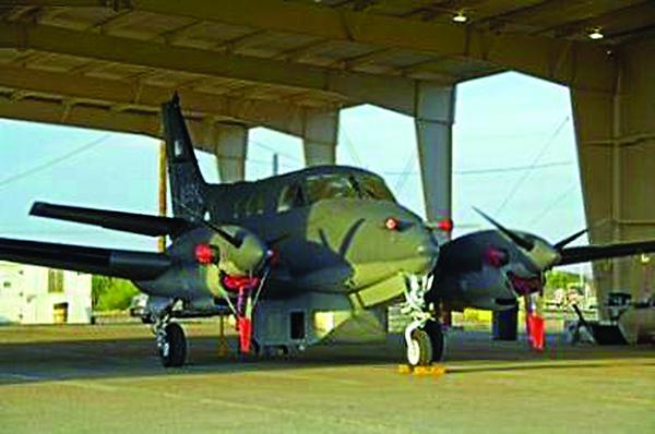
Gorgon Stare was developed for unmanned aerial vehicles (UAVs) to increase time on station. An earlier similar but separate Air Force/SAIC wide-area surveillance sensor system, Blue Devil Block 1, already is flying on manned aircraft. Four of these contractor-flown Beechcraft King Air C90 unpressurized propeller-driven aircraft are limited in altitude and about three hours on station in Afghanistan before having to land and refuel.
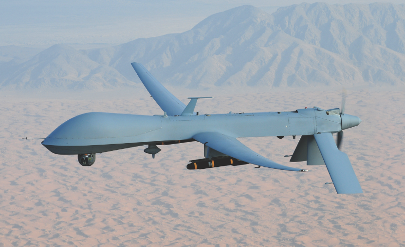
“The best way to increase sensor time over the battlefield was to put a wide-area sensor system on the USAF/General Atomics Aeronautical Systems MQ-9 Reaper UAV,” the defense official says. Exelis (formerly ITT) and Sierra Nevada Corporation developed and produce Gorgon Stare. This system, an advanced capability follow-on to Blue Devil, is mounted in a pod for Reaper missions. Gorgon Stare operates constantly in both visible and infrared wavelengths to downlink real-time motion video of city-size areas. Because Reaper is an armed UAV, it not only can provide critical ISR but also, if necessary, can quickly prosecute attacks once targets are identified.
This stabilized Gorgon Stare sensor system’s multi-megapixel multiple sources provide real-time data to warfighters. Gorgon Stare simultaneously generates high-resolution imagery of areas within the sensor’s footprint. Users can track and engage multiple targets within its field of view.
“Simultaneous industry efforts already were underway when generation of an urgent operational requirement emerged for a wide area airborne sensor in Afghanistan,” the defense official explains. This effort, which became Blue Devil 1, also was supported by the National Security Agency. Electronic emissions can be used to cue the sensor system. The Joint Improvised Explosive Device Defeat Organization (JIEDDO) also contributed funding for this program.
“This Blue Devil Block 1 system harnessed an earlier wide-area camera developed for the Angel Fire program in Iraq, updating and modifying it. The Blue Devil-1 camera also is coupled with a relatively new nighttime capability from Goodrich Corporation [now UTC]. Developers soon learned that looking for specific targets within a wide area wasn’t good enough. Adding full motion video cameras provided the answer,” the defense official maintains.
“Real-time imagery is transmitted from Blue Devil sensors on C90 aircraft to individual troops on the ground, or to ground stations,” the official continues. “The system demonstrates integration of wide-area and narrow-field-of-view sensors in the same package.” Coupled to advances in signals intelligence sensors, this system quickly satisfied commander’s needs, all in a single pod, the official stresses. Moreover, Blue Devil 1 proved successful in locating and identifying hidden improvised explosive devices, saving soldiers lives.
Contractor-flown C90 aircraft, now equipped with Blue Devil 1, flew earlier in Iraq. There they operated with an Angel Fire sensor system. Developed by the Air Force Research and Los Alamos National laboratories, Angel Fire enabled an early persistent wide-area sensor capability with its 90-magapixel day-only camera. These C90 aircraft flown in Iraq later were stripped for installation of Blue Devil in Afghanistan, the defense official discloses.
Angel Fire was sent to Iraq hurriedly to support U.S. Marines during the battle for Fallujah. The enemy, using truck-mounted mortars for shoot-and-scoot tactics, could fire and move before a quick reaction force or counter battery fire could respond. This sensor linked its real-time imagery to the tactical operations center, covering a 4-kilometer by 4-kilometer area.
“Angel Fire data soon overwhelmed the Marines. This system was brand new and did not come with directions,” the defense official points out. “After Fallujah, the Marines didn’t see much use for it, and the Angel Fire aircraft returned to the United States and were stripped.”
Earlier wide-area sensors in Iraq, such as the Army’s Constant Hawk, provided daylight-only wide-area imagery but without a data link capability. A disc stored the imagery onboard, the aircraft landed and the disc was transported to Germany for intelligence analysis. The analysis came back to Iraq, but often too late to be useful. “But it was a start, and Angel Fire took the next step with a digital data link relaying imagery in real time,” the defense official relates.
“Still, an urgent need existed for a wide-area real-time airborne sensor capability, one that could stare at a large city-size area. However, that is a lot of territory to observe, whether day or night. No one was prepared for the boatload of data, terabytes per mission,” the defense official claims. This imagery quickly overwhelmed the datalink pipes. A number of simultaneous efforts were underway in U.S. industry to resolve these issues. Innovative engineering and technical maturity soon materialized, and Blue Devil 1 emerged.
“This technology was integrated in a single pod, installed on four of the C90s and shipped to Afghanistan, where they continue to operate. Combat commanders, both from special operations and conventional forces, continue to clamor for wide-area airborne surveillance sensors, especially with the persistence of unmanned aerial vehicles,” the defense official emphasizes.
“The Blue Devil aircraft are limited to line-of-sight datalink imagery transmissions—about 120 miles,” the official continues. “However, at the bottom of that link is a USAF expeditionary processing, exploitation and dissemination cell using a distributed common ground station. This organization provides real-time, face-to-face support for warfighters. They sit where the warfighters sit, speak a common language and answer their questions in real time. This is an amazing capability and it makes combat commanders very happy,” the official declares.
“When we first went to Afghanistan with Blue Devil, the reaction was, ‘Who are you and what are you doing here?’ Now, it’s, ‘Where do you think you’re going? Oh no, you’re staying right here,’” the official emphasizes.
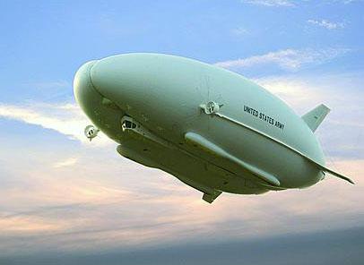
Yet another persistent wide area sensor program is the Army/Northrop Grumman Long Endurance Multi-Intelligence Vehicle (LEMV). Designed to sustain 21 days on station, this hybrid airship vehicle harnesses a variety of ISR sensors. They include moving target indicator radar, electro optical and infrared sensors, communications relays, friendly force tracking, signals intelligence and electronic countermeasures.


Comments