U.S. Army Expands Combat-Proven GeoGlobe
 |
The U.S. Army’s BuckEye system provides aerial coverage of the terrain in Afghanistan that is processed and fed into the GeoGlobe database. |
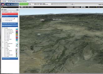
The U.S. Army is pushing to provide manageable amounts of three-dimensional terrain visualization imagery from its GeoGlobe database down to the individual soldier. The imagery soon will become available in PDF format so that it can be viewed on handheld devices to improve situational awareness, mission planning and decision making.
GeoGlobe may be one of the unsung heroes in the military technology realm—widely used but not well-known. The system has been in Afghanistan for two years, where it currently is available on designated servers in the southern and eastern regional commands and on 50 laptop computers that soldiers are using in remote forward-operating bases. It is accessible via both classified and unclassified networks.
GeoGlobe currently is not available at lower levels or on handheld devices simply because of the amount of data it contains. “Handhelds don’t have quite the horsepower to do real-time three-dimensional [3-D] visualization. They are not quite there yet for this application. I don’t think even a tablet could do it just yet,” Todd Blyler says. Blyler is a team leader within the Warfighter Geospatial Production and Support Directorate at the Army Geospatial Center (AGC), Corps of Engineers facility, Alexandria, Virginia.
But AGC officials now are integrating GeoGlobe, formally known as Army Geospatial Enterprise GeoGlobe, with a product known as GeoPDF, so that individual soldiers can download smaller chunks of GeoGlobe data prior to a mission and take it with them for greater situational awareness.
GeoGlobe also is installed on major command and control systems, such as the Distributed Common Ground System–Army. It also has been installed at the Army Geospatial Planning Cells that support combat theater priorities and maintain geospatial databases for the Army Service Component Command, combatant commands and joint force commanders.
One advantage GeoGlobe offers over other terrain visualization tools is the ease with which users can integrate intelligence data from a variety of sources, providing layers of tailored information on top of the terrain imagery, Blyler says. “The warfighters are able take data from many of their other sources in theater and put it into their globe visualization. That allows them to turn on and off different layers of information from all of the other intelligence sources they have running in theater,” he explains. Additionally, GeoGlobe provides a number of tools such as terrain analysis, route planning, measurements, markups, annotations and collaboration tools.
“The individual soldier doesn’t need to take the whole world with him. He just needs his area of operations. So, he connects to the server, figures out his area of interest, chips out a little piece of the database onto a PDF, maybe stores it on a handheld, and then runs disconnected from the network on a low-end device, so that he has a visualization capability that will help him to complete that mission,” Blyler explains.
GeoGlobe, which is based on a commercial product from Skyline Software Systems Incorporated, Herndon, Virginia, will become available to warfighters this spring in a two-dimensional PDF format, and the 3-D PDF will not be far behind. “We have a small effort underway right now to provide just a two-dimensional capability. While it’s coming out of GeoGlobe, a three-dimensional visualization, it’s losing that 3-D component. Step two will be to provide a real 3-D visualization chip of information from a master server. We could have a 3-D capability probably within the coming year,” Blyler says. “The technology exists. We just have to do some integration.”
Merging GeoGlobe and GeoPDF makes geospatial information more available simply because the format is more widely used than terrain navigation programs. “Almost nobody has a geospatial application on their computer, but everyone has the capability to read a PDF document, whether it’s a desktop, laptop or handheld device,” he points out. “We needed a way to get these heavyweight geospatial applications into the hands of an end user, who is probably not a geospatial information systems geek but who is somebody who needs to get a job done.”
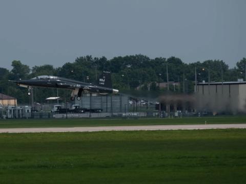
Using GeoGlobe, warfighters can view the entire planet or can focus on a particular area down to a 10-centimeter resolution. The terrain imagery is provided from different sources, which depends on the user’s need to focus tightly. Higher-level images—of the globe or of a large geographic region, for example—are provided via satellite, but 10-centimeter images come from airborne intelligence, surveillance and reconnaissance systems, primarily the Army’s BuckEye airborne sensor package.
BuckEye began initially as a rotorcraft-based capability, but it since has been installed on both manned and unmanned airplanes. The system has been used in both Iraq and Afghanistan, providing imagery of tens of thousands of square miles. In Afghanistan alone, the system has provided more than 23,000 square miles of data. BuckEye completed operations in Iraq in 2010.
Blyler credits the 101st Airborne Division, Fort Campbell, Kentucky, and the 1st Cavalry Division, Fort Hood, Texas, with much of GeoGlobe’s success in Afghanistan. The system first was provided to the 101st Airborne’s terrain team. “The local groundswell was overwhelming for this new tool. The 1st Cavalry picked up where the 101st left off and really ran with it over the past year. They turned it into one of the tools of choice for providing a common operational picture because of how they’ve implemented it,” he says. “We provided a good foundation of data—imagery and elevation maps—but the warfighters were able to take it to the next level by bringing in many other types of information to make it a one-stop shop for their common operating picture capability.”
Using GeoGlobe data enables warfighters to obtain the level of resolution that fits their needs. “As you zoom in, you might get down to commercial satellite resolution that may be on the order of one or two meters per megapixel. Then, as you continue to zoom in, you might get to a tenth of a meter per pixel—very high resolution that can show people in parking lots,” Blyler relates.
The GeoGlobe database is updated continually with new data and imagery on a daily basis with most of the new imagery coming from the BuckEye system. “As new imagery is collected over certain areas, we’re processing that and posting it up on our server. That’s one of the nice things about the technology we’re using. We can incrementally add data to it without having to go back and recompile the entire data set every so often,” Blyler says. “We have BuckEye flying constantly over theater right now. It’s an immense amount of data coming in, so just keeping up with that data and putting it on the servers is keeping us busy.”
In addition to the current work, the AGC officials plan to federate GeoGlobe servers, making the data more accessible worldwide. “We call it the enterprise GeoGlobe because you can have multiple servers, and the servers can communicate with each other, so that users can see a single visualization. We can have servers distributed around the globe; particular units can load data on the globe that is unique to their area of operations and it all combines seamlessly,” Blyler adds. “End users don’t have to go to [U.S.] Southern Command servers to see imagery over South America or to [U.S.] European Command servers to see imagery over the Alps. Maybe our website would be a starting point, but from there you hit that federation of servers and see all that data coming in from all those different sources.”
The federation project has been placed on a back burner with support to the warfighter being the primary focus. Blyler’s team of about 12 people simply does not have the personnel resources for completing the project just yet.
Some obstacles are more procedural than technological. “We need to go through all of the bureaucratic issues to open up firewalls and get these servers communicating with each other,” he reveals. “Maybe next year we can get back around to fixing that.”
Additional improvements could include streamlining data processing capabilities so that imagery can be updated more rapidly. “We’ve identified a few areas where we think we could have imagery posted within a matter of hours or minutes once it’s collected,” Blyler says. “We’re geospatial geeks here. The more we work with it, the more we see areas that can be improved.”
WEB RESOURCES
GeoGlobe: www.agc.army.mil/fact_sheet/AGE_Geoglobe_FactSheet.pdf
BuckEye Unmanned Aerial System: www.agc.army.mil/fact_sheet/BuckEye_UAS.pdf
Army Geospatial Center: www.agc.army.mil


Comments