Covering the Six for Homeland Joint Operations
 |
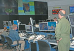
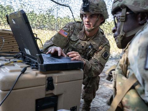
| The National Geospatial-Intelligence Agency’s Palanterra is a family of spatially and analytically enabled Web-based interfaces. Personnel at the North American Aerospace Defense Command/U.S. Northern Command (NORAD/NORTHCOM), Peterson Air Force Base, Colorado, fuse imagery from Palanterra and other sources such as Google Earth to determine the ground truth in an area of operations. |
At the military command level, bringing order to chaos during national emergencies is about more than technology. For the command in charge of homeland defense and support to civil authorities, it’s about the information: how to gather it, how to share it and how to integrate it. As a result, the command has redefined the term “joint operations” by using innovative ways to coordinate personnel and information input from all of the military services—including the Coast Guard and National Guard Bureau—and as many as 150 mission partners.
To meet the challenges these missions pose, personnel at the North American Aerospace Defense Command/U.S. Northern Command (NORAD/NORTHCOM) know that technology is available to accomplish just about any task. The command is located at Peterson Air Force Base,
Col. Brian Jones,
In addition to coordinating with federal government agencies such as the Federal Emergency Management Agency (FEMA), the command must work with authorities in 54 states and territories, which are sovereign in their own sense, he adds. In terms of aiding during emergency response, the colonel explains that the command must tailor its actions based on the needs of the lead federal agency or the governor of the state. “It makes for a challenging mission, and we try to use whatever technologies are available out there to help us work that mission,” he notes.
All missions the command carries out or supports involve information sharing. And, according to Mark Dalla Betta, chief, information management, NORTHCOM, Col. Jones’ assessment of the challenges of joint operations is correct but only scratches the surface. Some of the complexities of not only day-to-day operations but also contingency operations such as security for the presidential inauguration create multifaceted issues that the command must address.
“The type of information that you’re talking about actually is more domain-specific, and each domain covers a specific area such as air, maritime, land, space and missile, and cyber. Each domain is working within itself—within that specific capability requirement—and then it’s a challenge to make sure that it shares that information with the other domains and the agencies responsible in those areas all the way up to the CCD [command center director],” Dalla Betta explains.
Keith H. Snook, information exchange broker, NORTHCOM, adds that the information required to defend the nation or respond in a crisis is not only domain-specific but also event-specific. “We’re looking for completely different information in a
For example, prior to landfall of Hurricane Katrina, the command needed to know the location of the refugees, water and food supplies, and hospital ships. In addition, command personnel required information about the National Guard Bureau’s plans as well as search and rescue preparations.
Assistance to civil authorities during the
When all of these elements of emergencies collide—different organizations, different needs, different circumstances, different resources and different information systems—NORTHCOM’s job is even more about the information than about the technology, he emphasizes.
Col. Jones points out that while information sharing occurs both horizontally and vertically in both of the command’s primary missions, it occurs differently for the homeland defense mission than it does in the support to civil authorities mission. In the former, missions require the typical Defense Department architecture and communications capabilities that most other combatant commands possess. “That’s a very structured communications requirement and architecture,” Col. Jones explains. “On the flip side are the civil support missions where we may be dealing with the Secret Service, which is using a Google Earth-based software to display its information. We have to be able to do both,” the colonel says.
 |
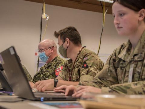
| U.S. and Canadian personnel monitor North American maritime and air domain activity in the NORAD/NORTHCOM Command Center. The center opened in May 2008. |
Based on its past experiences, the Secret Service set up committees to address everything from security to crowd control to medical aid. Once the requirements were identified, the agency turned to the Defense Department as a provider of unique capabilities, in this case the communications systems.
The Secret Service then set up the
Dalla Betta notes that NORTHCOM initiated this capability when it assisted
“We recognized [that commonality] about six months prior to the
To address the issue of information overload, NORTHCOM turns to the combatant commands (COCOMs) for guidance. The combatant commander information requirements (CCIRs) come from the other nine COCOMs. Then NORTHCOM breaks down these CCIRs and, as an emergency or security situation occurs, or when an exercise is being planned, the information needs that are specific to that event are identified and approved.
For example, in the case of flooding caused by hurricanes in
To prepare for these contingencies, FEMA performs—with the states and region by region—a gap analysis to ascertain what items will be needed in case of an emergency. This assessment enables NORTHCOM to confirm the number of assets that are available and determine their location.
“This process is different than it was even two years ago, that’s how quickly it is evolving,” Col. Jones says. “For instance, in
“That was something that we had thought about doing before, had war-gamed a couple of times and worked in exercises, but that’s the first time we ever actually pulled it off. We had a lot of great lessons learned there, and we continue to work with [the U.S. Department of] Health and Human Services and DHS on forward-planning that into the future,” the colonel adds.
The agencies that NORTHCOM works with are intensely event-driven, explains Brenda Miller, information manager, Interagency Coordination Directorate, NORTHCOM. Although activity may appear scattered, Miller says her directorate tries to be very structured in the way it follows the national response framework. This year-round coordination ensures that the right information is provided to the right people at the right time, she adds.
“For example, this command has worked very diligently to change the focus from information sharing to information integration. We utilize the personnel to integrate information. As was alluded to before, part of that is integration of the Homeland Security Information Network, where we’re able to facilitate that as well,” Miller shares.
Snook agrees that information integration is crucial to joint operations when so many agencies as well as military services are involved in responding to a security or emergency-response event. “I think we’re starting to realize that we understand information integration, we understand the requirements for it and we understand mission integration. Each one of the agencies that we work with has a different mission. How do you integrate those to get the effect for that event at that specific time?
“The last piece is when you understand how to integrate the two—the mission and the information. So it’s larger than mission integration, and it’s larger than information integration. You actually start turning that into knowledge, and it becomes knowledge sharing versus information sharing,” Snook says.
One way the command accomplishes this is through information exchange brokers, the people in the loop who are looking for information gaps and seams so integration can be done properly, he explains. These positions and the capabilities that surround them were established in NORAD/NORTHCOM in 2003 when the command realized that it had become very good at the need-to-know culture. Improvements in identifying the gaps and seams occur every time the command supports civil authorities in an emergency-response event or National Special Security Event, Snook adds.
Many times, integrating these lessons learned along with the information is a matter of processes and procedures, rather than technology as the panacea. Dalla Betta led the effort to ensure that these two crucial items were addressed in what resulted in the Strategic Operations Information Sharing (SOIS) plan of action. “It started out with butcher-block paper on the wall—I kid you not—and we broke up into groups. Each group had a different question that it had to brainstorm on. We had people from all different venues within each area: some IT folks, some operations folks and some with varying backgrounds. And as we moved around, we continued to pare this down until we came up with this strategic plan,” he explains.
The SOIS lays out the processes between the National Guard Joint Operations Coordination Center, the DHS network operations center, the National Military Command Center (NMCC) and the Global Situational Awareness Facility (GSAF), which is located within NMCC and staffed by members of the Homeland Defense sector of the Office of the Secretary of Defense in the Pentagon and N2C2 personnel. “Once we laid those processes out, we were able to look across the board and see not only the commonalities and how everybody does business—crosswalks, CCIRs and those sorts of things—but also we started looking at the common tools and capabilities we can all use if everything else fails,” Dalla Betta relates. For example, agencies all can access and post information to the HSIN. The SOIS will soon be revised to bring it up to date, he adds.
The activity also enabled Dalla Betta’s team to analyze gaps. As a result, the N2C2 identified capabilities that did not exist, as well as the direction it should go with some of its other initiatives.
“It keeps coming back to the fact that it’s not about the technology, even though technology is important and used as an enabler. It’s about how you interact and relate with all your different mission partners, understand the challenges that they have and try to mitigate those to make sure you accomplish missions,” Dalla Betta states.
In terms of industry assistance, Dalla Betta contends that oftentimes companies create solutions to problems that do not exist. When military commands and federal agencies see these exciting technologies, they attempt to find a problem that fits the solution. “A requirements process that actually is reactive to a requirement as opposed to the other way around is a good place for industry to start,” he says.
Snook adds that the change in acquisition processes has in some ways confused industry. Companies are accustomed to providing solutions to a contract line item number, but today the commercial sector needs to explain where it is going, where it can go and how close and fast it can arrive there, he says.
Web Resources
North American Aerospace Defense Command: www.norad.mil
National Geospatial-Intelligence Agency Palanterra: https://palanterra.nga.mil


Comments