Blanketing The Ground With Sensors
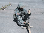 |
| Training for the placement of unattended ground sensors (UGSs) takes place at Fort Bliss, Texas. Tactical and urban UGSs are both part of Future Combat Systems (FCS) equipment and are scheduled to be fielded to infantry soldiers by 2011. |
The proliferation of inexpensive yet high-quality transducers for acoustic, seismic and optical images, along with inexpensive and low-power digital signal processing and radios, enable improved target detection, classification, tracking and even location prediction. These capabilities are being demonstrated now in the prototypes of the U.S. Army’s Future Combat Systems Tactical Unattended Ground Sensor Program.
Today’s remote, unattended ground sensors (UGS) fall into four broad categories: proximity, cued set, intelligent nodes and networked fields. Proximity sensors are the simplest devices. They are typically of a single modality such as acoustic, seismic, optic, magnetic and heat, normally with only a single transducer such as one microphone, geophone, camera, magnetometer or infrared detectors. These are very effective for detection and, with increasingly capable processors, can achieve limited vehicle classification and reduce false alarms.
The most recently fielded systems have been cued sensor sets that use an acoustic or seismic sensor to trigger a camera, eliminating the need for continuous recording or transmission. Often, the cueing transducer is co-located with the camera in a single package, although sometimes the cueing sensor has been placed well forward in the center of the camera’s field of view. Non-U.S. armies have tested a cued sensor set where any of a number of local sensors—seismic, acoustic, magnetic—can cue the panning camera to a specific azimuth to take a series of pictures, making target identification easier.
The military services recently have tested, and in some cases fielded, the first set of intelligent nodes, which comprise multiple, similar transducers that enable the node to determine directionality. Because proximity sensors have only a single transducer, they can monitor intruders as they move closer or farther as the signal strength increases and decreases. However, they cannot know from which direction the intrusion occurred or, with any accuracy, the intruder’s closest point of approach.
Intelligent nodes have three or more microphones or geophones that determine directionality. For various operational and design reasons, these intelligent nodes typically will be multimodal also, combining acoustic, seismic, magnetic and sometimes electro-optic instruments. Today’s sniper detection systems usually have multiple acoustic microphones to achieve directionality.
Now emerging from laboratories are networked sensor fields—consisting of many separate nodes linked by short-haul radio to a local signal processor—that analyze the nodes’ reports and provide long-haul connectivity. The most powerful of these networked fields incorporate intelligent nodes.
Although some modern UGSs seem to transcend these four categories, the taxonomy remains useful for assessing a system’s capability and projecting its limitations.
The Army is developing next-generation sensor capabilities. These sensors are becoming increasingly sophisticated and less expensive, using modern transducers, computer chips, radios and emerging network-centric architectures.
Intelligent sensor nodes have a number of significant improvements over the last generation of systems. Instead of listening with just one microphone, these modern sensor nodes each have multi-element arrays consisting of five microphones pointing in different directions. By analyzing the sound wave as it passes over the five-microphone array, the signal processor can determine the direction to the target.
Each sensor node not only has multiple acoustic microphones but also a three-axis seismic geophone. By assessing both the sound and vibration, the node can greatly reduce false alarms and improve its target classification capability. A multi-axis magnetic compass provides orientation.
Today’s powerful digital signal processors enable very sophisticated algorithms to analyze the seismic signal in strength and rate of occurrence, as well as the acoustic signal across a broad frequency spectrum to identify peak amplitudes and harmonics. They also enable the algorithms to correlate both seismic and acoustic results to aid in classifying and identifying targets. Target direction in azimuth is determined for vehicles and impulse events such as mortar or artillery launches. Local processing drives down nuisance and false alarms as well as the quantity and length of messages transmitted.
With two-way radios in every node, the operator can provide additional information to the signal processor, improving its algorithms or telling it to “sleep” to conserve battery power. When deployed alone, these sensor nodes often use the Global Positioning System (GPS) to find their location and provide a common time reference. Thermometers and other transducers also may be included.
Each sensor node can determine and report the detection of dismounted personnel. For vehicles, the individual sensor reports the detection time of the target and its type, azimuth, approximate range and angular velocity. For events such as mortar or artillery launches, the node reports the time of arrival of the impulse event and the azimuth to event. The node also estimates the launch tube type or length.
As powerful as the new sensor nodes are, their power is multiplied when they are deployed in fields, communicating among themselves in intelligent sensor fields. A map of the sensor nodes is generated either by GPS or the two-way radio system itself. Knowing the nodes’ locations and their nominal target detection ranges will, in the absence of current detections, provide confidence that there are no targets within the general area.
 |
| Unattended ground sensors are designed to be concealable on the battlefield. |
For impulse events, the processor can use time delay of arrival and reverse azimuth from the multiple sensor node reports to determine time and location of the launch. By deriving and plotting target location each second, the sensor field can determine and report the target’s speed and direction. With multiple sensors classifying the target over time, sensor reports are compiled, and a voting procedure can be used to increase confidence in the target classification.
The radio network ensures communication throughout the sensor field even after one or more of the nodes have dropped out. The radios also enable the operator to pass meteorological data to the sensors to improve their total performance. For example, unusual wind, temperature, humidity or barometric pressure may affect the speed of sound in certain acoustic sensor calculations.
The field’s gateway or command and control node gathers the time-stamped reports from the many intelligent sensor nodes in the field. Each second, it can process this data for individual vehicles to determine and report the velocity vector, which includes the date, hour and second; the target’s location; and its heading in degrees and speed in kilometers per hour or meters per second. This information enables the user to dead reckon a vehicle’s location for some time period after the latest report.
Networked sensor fields achieve more than just connectivity among various sensors, vehicles and combat units. The term network centric is used to emphasize that it is far more than just everyone having access to information. When the sensor field reports the location, time, velocity and classification of a target, the network can combine it with reports from other fields and other sensor systems such as unmanned aerial vehicles (UAVs). This information can be used to determine if a target is new or a second/later report of a previously detected vehicle. As a result, the reported velocity becomes very important. This function also puts the pieces together to help the analyst determine order of battle.
Combat commanders talk about information overload. While it is important to have access to all the information, it is equally important—and sometimes even more imperative—not be inundated with irrelevant information. This is where the role of the network comes in. While not everybody needs to know immediately about the six tanks, for example, the unit they are heading toward most certainly does need to know quickly. The properly prepared network can perform this function automatically.
Also, the network can store information for later use. A vehicle by itself at a certain time or place may not be important; but network-enabled data analysis might reveal a pattern that precedes certain events, so appropriate measures can be taken.
Because the intelligent sensor field makes very accurate information available throughout the network, it can be used to make other systems far more efficient. Applications can include cueing several systems: UAVs to make limited flight time more efficient; artillery to be timelier against moving targets; intelligent munitions system operators to make those fields more effective; or maneuver forces for better use of their cavalry and reserve units.
The promise of networked sensor fields occurs on many different levels. Individual sensor nodes are very sophisticated—they send quality data only after it has been scrubbed. The sensor field coalesces the data, producing useful information that is sent to the network. The network combines the information from multiple netted sensor fields and other sources to produce actionable intelligence, which is sent immediately to the units that need to know it.
Dean Risseeuw is a former
Web Resources
Future Combat Systems: www.fcs.army.mil
Unmanned Ground Sensors: www.fcs.army.mil/systems/ugs/index.html


Comments