U.S. Navy Dives Deep Into Data Density
While the use of unmanned surface vessels is helping the U.S. Navy overcome the tyranny of distance, the key component is the data collected and strategically distributed across decision-makers and allies.
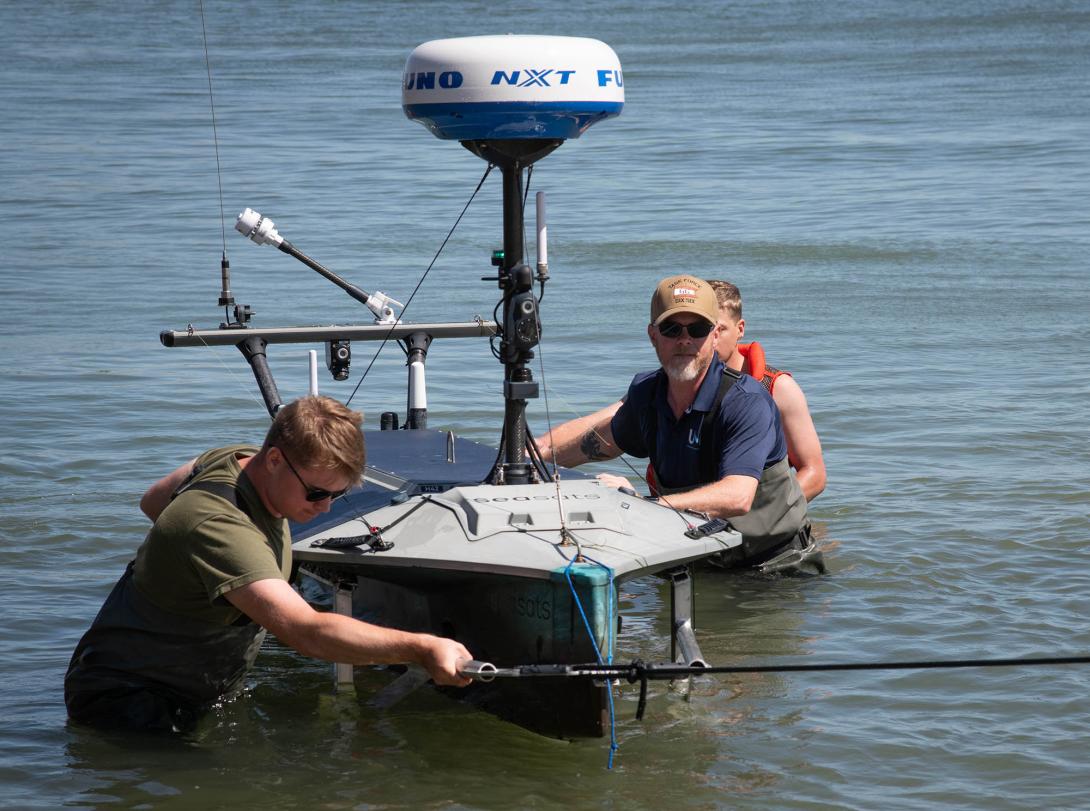
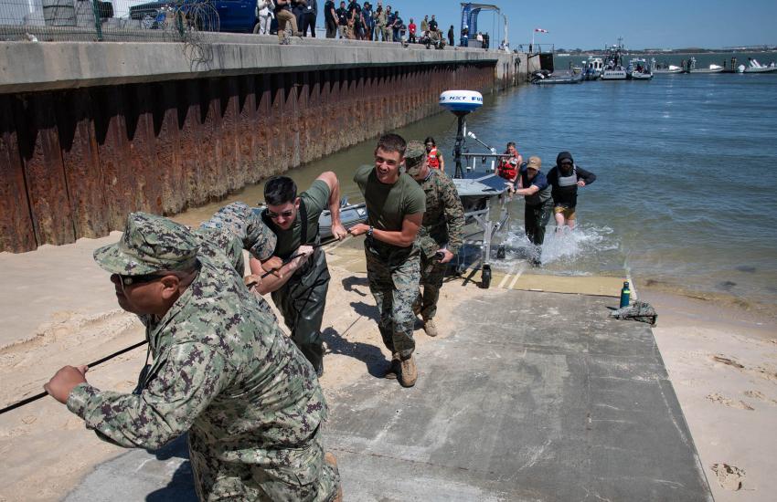
In September 2025, the Naval Information Warfare Center (NIWC) Atlantic’s Unmanned Naval Innovation Team (UNIT) successfully completed a unmanned surface vehicle (USV) journey across the Atlantic Ocean. The 12-foot and 300-pound vessel, called “Lightfish” and developed by Seasats Industries, was launched from Sullivan’s Island, South Carolina, and recovered in Troia, Portugal. The journey took just 63 days, beating previous records of such attempts.
“For us as individuals and as a unit, we hadn’t crossed the Atlantic ... we hadn’t gone anywhere remotely as far,” Michael Grass, UNIT Rapid Capabilities lead, told SIGNAL Media in an interview. The mission proved the long dwell USV concept, he continued.
“It confirms that we can power-project, that even over long distances, we can put an unmanned vessel into a place of our choosing, at a time of our choosing and then carry out [maritime domain] and [intelligence, surveillance and reconnaissance] missions,” he explained.
Although the autonomous 4,000-mile voyage was a significant milestone for the team of engineers and operators, another major triumph was the seamless coordination of command and control (C2) across various geographical points.
“We had multiple watch floors that would take over watch,” Grass said. “One fleet ... might be calling it a day, we would turn over to another fleet that might be waking up so that there was persistent oversight and monitoring of the vessel as it made this first voyage across the Atlantic.”
The operation was a training opportunity for fleet forces as they learned to incorporate data packages into multiple maritime operational watch floors. “As one watch floor was standing up, they could see those data packets, see the position, see the camera, see the data on each watch floor,” Grass stated.
Sensors aboard USVs are vital for actionable data production, Grass added, noting the valuable advancement in the systems.
“In the early days, data would go onto a watch floor for a two-week exercise, and then when the event was over ... the data gets flushed,” said Grass. “What we can do now is collect that data from line of sight, or beyond line of sight, resilient and assured communication channels, and move that data to where it matters,” he said.
“For us, that means getting that data to the maritime operational watch so that the battle watch captain can actually use that information [and] can make decisions,” Grass added.
Additionally, Grass highlighted the ability to share data with coalition partners, including NATO. “We need to make sure that we’re able to collect and pass data on specific message data formats like a [Standardization Agreement], for example,” he said. Grass’ team has built a specific data architecture, which would allow for seamless data sharing.
The Lightfish mission was also strategically timed to arrive in Portugal during NATO’s Robotic Experimentation and Prototyping with Maritime Unmanned Systems (REPMUS) exercise. The event involves all NATO countries, along with additional partners, to partake in testing.
“Part of our goal was then to be able to share data across those NATO partners,” said Luke Overbey, senior scientific technical manager for autonomous C4ISR at NIWC Atlantic.
Another aspect of data sharing lies in interoperability, Overbey added. “If there are multiple platforms for multiple different companies, being able to have a single interface where the operator can be able to see all the data coming in, as well as be able to then execute mission plans to the extent that things are not autonomous, to push missions for autonomous platforms to them, and those things can work in an interoperable fashion. That is part of what our major goals with the broader program are.”
Since the completion of the first transatlantic mission, all collected data has been stored for further training and development.
The camera imagery and full-motion video footage are used to train automated target recognition, Grass explained. Additionally, Overbey noted, the data can be used for more advanced mission analysis and artificial intelligence (AI) training.
Notably, AI capabilities were used during the autonomous journey for essential tasks such as avoidance maneuvering and vision-based detection. While some of those tools were provided by Lightfish provider Seasats Industries, others were government-developed, Overbey said.
When asked about the challenges of such missions, Seasat Industries CEO Mike Flanigan spoke on critical communications. Automation and data density to ensure all sensors collaborate and work together is an ongoing process, he said.
“Pretty much everyone has this problem,” Flanigan told SIGNAL Media. “We can put these boats out to sea, and they collect a ton of data … every boat has a capability to generate hundreds of gigabytes of data potentially per day, probably more than that.”
The company has therefore used AI and machine learning tools to tackle the heavy data processing load, Flanigan explained. As the five-year-old business progresses, Flanigan looks forward to testing more long-range missions, including the Indo-Pacific region.
Although last year’s attempt to cross the Pacific Ocean was unsuccessful, Seasats completed a journey from San Diego to Japan earlier this year.
“We’re purposefully pushing the boundaries of the vessels,” Flanigan stressed. “We sailed [Lightfish] straight into the eye of a nearly full-blown typhoon on the way to Japan,” he said, noting the 80-knot winds during the 2024 transpacific journey. “That vessel was destroyed, and we learned a lot because we were able to stream all this data back from it, so we took that learning and rolled those upgrades out to our entire fleet.”
The lessons learned allowed for a five-month-long, 7,500-mile autonomous journey passing Hawaii and Guam.
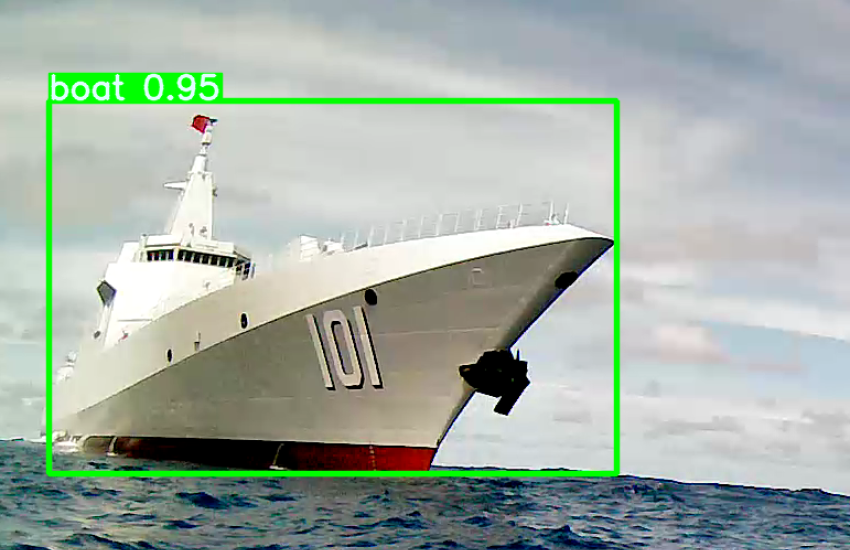
Along its course, Lightfish crossed paths with a Chinese vessel, news first reported by Breaking Defense.
The Seasats team was alerted to the approach through the AI-enabled sensors aboard the USV.
“When we’re operating in more contested environments for the Navy, we have the ability to control the vessel’s signature and make it go very quiet,” Flanigan explained. “We have various things that we can do to protect the vessel and its data.”
For the specific case with the Chinese destroyer, he explained, Lightfish was visible since its position was broadcast on the Automatic Identification System, or AIS.
The occurrence highlights the value of unmanned systems, Flanigan said. “We had this 12-foot vessel sitting there collecting data on a [large Chinese destroyer],” he continued. The data collected and the cost and risk of human life are wildly skewed, he said.
Similar reported instances have involved surface drones being towed away and later returned.


Comments