Army Corps of Engineers Research Supercharges Operational Planning

For years, operational planners have relied on generic software to build the plans that guide every mission within the Department of Defense.
Unspecialized tools like Microsoft PowerPoint, Word and Excel may work for basic tasks, but they fall short in today’s fast-moving, multidomain operations. Critically, they lack integration with other command and control (C2) systems and fail to provide planners with live, authoritative data on crucial planning factors, like unit readiness, infrastructure and weather.
Working around these limitations, planners often manually piece together plans, juggling multiple systems and files to get the job done. However, this approach introduces a serious problem: since changes to the plan are not automatically updated throughout the team, each staff member works from a different version. This issue is magnified even further in joint planning scenarios, where plans are not only circulated among a team but also between multiple organizations, with no clear source of truth. This fragmented process leads to errors, delays, miscommunications, duplicated efforts and wasted time.
As planning demands have evolved, the question has become clear: how can we empower planners with tools that are purpose-built for the complexity of modern military operations?
A Solution for Planners, by Planners
To resolve the critical need for better planning tools, the Engineer Research and Development Center of the U.S. Army Corps of Engineers launched the Map-Based Mission Planning (MBMP) project, leveraging the expertise of the Engineer Research and Development Center. Key operational stakeholders of the project, including Project Manager Mission Command, Program Executive Office Command, Control, Communications, and Network, and the Headquarters, Department of the Army G-3/5/7, provided feedback to ensure the project’s alignment with mission needs and objectives.
The result of the research, prototyping and development within the MBMP project is the Joint Planning Services (JPS) product, a web-based application suite purpose-built for strategic and operational-level planning. JPS solves fragmented workflows and version control issues by supporting all aspects of the planning pipeline. Grounded by doctrine such as the Army’s Military Decision-Making Process and the Joint Planning Process, JPS lets planners create, revise and brief plans all in a single space. This removes the need to cobble together outputs from multiple applications to produce a coherent plan.
Unlike generic tools, JPS is specifically designed to support planning activities. At its core is a dynamic map interface, within which users can create map overlays, create courses of action (COAs) and link map elements directly to documents like orders and phasing diagrams. These documents, which are crucial products of the planning process, can be created and edited entirely within the application suite. Every element of JPS is designed to speed up planning while improving clarity and coordination.
Facilitating Instant Data Access
In the context of today’s advanced military challenges, good planning relies on good data. More than ever, the success of an operation hinges on planners’ ability to leverage data to make informed decisions. Procedures such as terrain analysis, force and materiel logistics and COA generation depend on real-world conditions communicated to planners through authoritative data.
However, critical data is too often locked away in separate systems, forcing planners to jump through hoops just to get the information they need. These systems are not always designed to work together, forcing planners to manually extract, reformat and import data between platforms. This process is not only time-consuming and error-prone but also potentially dangerous. Without automated updates, planners may unknowingly base decisions on outdated datasets. In fast-paced operational environments, this lag can compromise a plan before it even begins.
JPS addresses this challenge through its integration of Authoritative Data Sources, a transformative feature that streamlines data access and ensures planners work with the most current information available. As a data-driven web platform, JPS can connect directly to data providers. Through live integrations with systems that supply data on geospatial intelligence, weather, materiel and the status of troops, JPS automatically retrieves and embeds current information into the planning interface. Planners can access up-to-date information on seaports, airfields, terrain features and unit readiness, all within the same environment where they develop and visualize plans. By reducing the need for manual data management and ensuring planners have access to reliable information, Authoritative Data Source integration within JPS enhances planning speed, accuracy and confidence.
Joint Operations and Data Interoperability
The scale and complexity of today’s operational planning missions mean that planners rarely work in isolation. When intricate problems demand joint or combined task forces, planners from different organizations must work together, requiring seamless coordination across services, commands and coalition partners. These groups have to reconcile their differing procedures (or integrate new ones, like the Joint Planning Process), coming to a shared understanding and working rhythm.
However, the problems that joint planners face are not only about teamwork. Technical barriers can also hinder collaboration. Planning and C2 systems are often siloed, built on closed architectures that operate on differing standards and workflows. Likewise, the crucial datasets that inform planning decisions are often stored in proprietary formats, limiting the ability to share information between systems. The result is a fragmented operational picture, where each stakeholder can only see part of the whole plan. This data incompatibility creates friction in joint operations, slowing down planning cycles and weakening coalition execution.
JPS addresses geospatial interoperability challenges through its Geospatial Data Sources framework, a foundational capability that enables interoperability at scale. This framework allows JPS to read and use geospatial data in many common formats, including open and proprietary standards. These formats are used to manage and display map data, like coordinates, terrain features and annotations. Within its Geospatial Data Sources framework, JPS supports widely used formats such as the Esri Shapefile, used in the ArcGIS suite, and the Open Geospatial Consortium Geography Markup Language, making sharing data across different platforms easier.
By supporting a range of geospatial standards, JPS ensures that staff can ingest, visualize and share data across diverse planning systems without needing custom conversions or workarounds. The Geospatial Data Sources framework acts as a strategic enabler, allowing JPS to integrate with joint and allied systems, facilitating shared understanding and synchronized planning across organizations. For commanders and planners, this translates into improved situational awareness and greater confidence in the information driving their decisions.
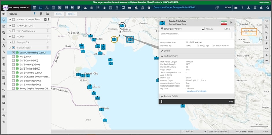
JPS provides planners with ready access to nautical and aeronautical data such as seaport details, airfield conditions and runway length, all displayed on the map.
Enhancing Collaboration
Military planning teams continue to rely on fragmented legacy tools, a result of sustained underinvestment in planning technology and a lack of understanding of planners’ actual software needs. Indeed, flexible software solutions can be as important to the military’s strategic advantage as access to data. As a result of a disorganized approach to software, real-time collaboration has been difficult within the planning sphere, leading teams to work in isolation, struggling with version control and outdated information.
Why has this gap persisted? While Microsoft introduced near-real-time collaboration features to the Office suite in 2010, adoption within military planning circles has remained limited. Even with an improved Office ecosystem, where collaborative editing was feasible given the right licenses and credentials, many teams have stuck to old habits, passing PowerPoint slides and Word documents back and forth instead of working together in real time. Interviews with experienced planners have confirmed the tangible impact of this gap: higher travel costs, difficulty updating plans quickly, version conflicts, and most of all, wasted time.
To solve this, JPS includes digital tools that mirror and enhance traditional planning methods, such as virtual whiteboards and real-time document editing. JPS allows multiple users to work on the same plan at the same time, reducing the need for in-person meetings and making it easier to update plans as situations change. This improves the speed and accuracy of planning, helps team members stay on the same page and strengthens coordination across units and with coalition partners. JPS is built to work securely across the Department of Defense’s major networks, including the Non-classified and Secret Internet Protocol Router Networks and the Joint Worldwide Intelligence Communication System, ensuring secure accessibility in diverse operational contexts.
Planning for the Future
JPS has proved what digital planning tools can achieve when purpose-built for military needs. Its innovations in real-time collaboration and live, authoritative data access have reshaped how planners operate in complex, multidomain environments.
The lessons learned from JPS are being carried forward into Spearhead, the Engineer Research and Development Center’s product for future-ready strategic and operational planning.
Spearhead brings the collaborative and data-fueled planning capabilities from JPS to an updated architecture in line with the Army’s Next Generation C2 initiative. The Spearhead application suite will deliver enhanced performance, broadened interoperability and a flexible, customizable user experience designed for future fast-paced operational demands. The suite will integrate with AI models, satisfying a growing demand in the Department of Defense for tools powered by military-focused machine learning models, enhancing COA generation and wargaming, and interface with other applications through the Army’s proposed Tactical Data Platform. Spearhead reflects a growing shift in the planning community—a move toward open, interoperable and adaptive systems. To stay ahead of tomorrow’s challenges, it is imperative that military leaders support and invest in planning tools designed to support the mission.
Michael “Reggie” Hammond is the project manager for the Spearhead project at the Engineer Research & Development Center (ERDC) Geospatial Research Laboratory (GRL) in Fort Belvoir, Virginia. He is a retired naval officer with almost 20 years’ experience in joint and Army strategic/operational planning, including eight years in the Joint Staff’s Joint Operational War Plans Division, and six years with the U.S. Army Corps of Engineers.
Ryan Delts is a computer scientist and configuration manager for the Spearhead project at ERDC GRL.
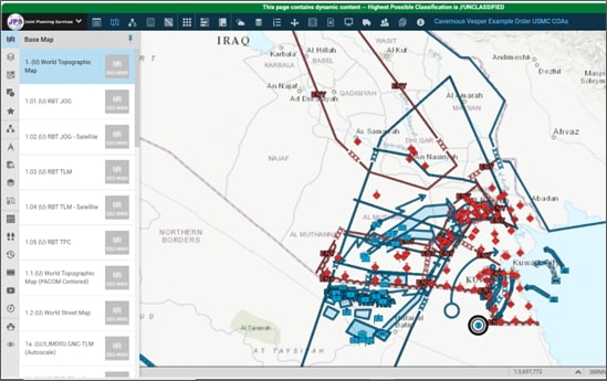
The base map in JPS can be easily swapped out with other maps, allowing planners to customize the interface to their needs.
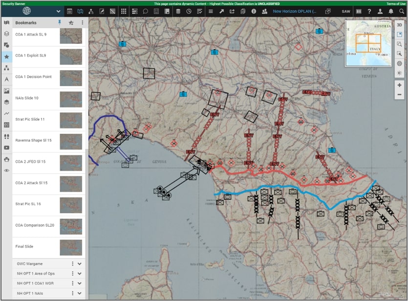
JPS features bookmarks, views of the map that dynamically update with changes to the plan, enabling easier and more detailed briefings.


Comments