Echelons and Partners Soon Will Be on Common Ground
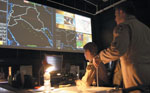 |
| Common Ground will standardize geospatial products so U.S. decision makers at all echelons and their coalition partners can obtain informa-tion they need without querying geospatial analysts for every piece of data. Here, coalition troops track an ongoing mission in Southwest Asia at this Combined Air Operations Center. |
The
The U.S. Joint Forces Command (JFCOM) and the U.S. Army Topographic Engineering Center (TEC) are collaborating on a program called Common Ground, which will integrate geospatial information and analysis capabilities with command and control information. The integration will occur across joint and multinational environments. Also involved with the program is the assistant secretary of defense for networks and information integration.
The effort is a Joint Capability Technology Demonstration (JCTD). These demonstrations provide transformational operational capabilities for joint warfighters, meet urgent combatant commander needs and are complete in one to three years. Leslie Winters, the division chief for the joint data and services division in the JFCOM Joint Capability Development Directorate (J-8), says that Common Ground is the number-one priority fiscal year 2009 JCTD as decided on by combatant command and service input. The program’s initial integration testing is scheduled for November 2009, with an operational user assessment in December 2009. A demonstration and military utility assessment are slated in January 2010 with technology transition beginning in 2011.
The main thrust behind the Common Ground program is to provide to the warfighter geospatial products and services and analytic products that previously have been missing because of technology or other reasons. The technology and need are now at a point where the military can offer geospatial capabilities more directly to the command and control sector. The TEC has developed much of the foundational language, semantics and syntax efforts that underlie the capabilities in the program. The JCTD will offer the geospatial products and enabling tools across all echelons of an operation as well as to coalition partners.
Common Ground will help eliminate stovepipes. Previously, the geospatial community’s management of command and control systems for the various service branches was fundamentally separate. The challenges for Common Ground are to create a force structure where information dominance is a priority and to discover a way to make the information easily accessible and usable by decision makers.
One way developers will solve the problems is by using standard data models such as the Joint Consultation Command and Control Information Exchange Data Model (JC3IEDM). The model was created and is managed by the Multilateral Interoperability Programme (MIP), an organization with 23 member nations, including the
Though the JC3IEDM is a standard adopted by multiple users, the implementation has not happened quickly. James Southerland III, operational manager, Common Ground JCTD at JFCOM, describes Common Ground as a pilot of sorts, leading the way for the standards and showing how others can use the licensing. However, the JC3IEDM is not the only standard that will be employed. Universal Core, for example, will be the cross-agency standard used to enhance interagency interoperability for the Director of National Intelligence, U.S. Defense Department and U.S. Homeland Security Department.
Through extensions made to the terminology in these types of databases, warfighters will be able to look up information using their own common terms without learning geospatial language. This will reduce the learning workload for troops and will enable access to geospatial information without the need for specialized personnel. The effort will enhance command and control by accelerating the decision-making process so coalition forces can take action before their adversaries do.
Common Ground will offer the tools and services necessary for troops to condense large amounts of information to smaller, more useful quantities for underlying functionality. Personnel at tactical levels will discover the information through Web services, and all information can be reused at various echelons and parts of the coalition so everyone sees the same map data. “If everyone looks at the same thing, it synchronizes the effort,” Southerland explains. In the past, multiple map sources have caused confusion on the battlefield. With Common Ground, operators can use unifying standards to place information into the database, and others can find it and use it to come up with the same answers to tasks such as route planning and obstacle locating at all levels.
Southerland explains the program by saying everyone has a chop at the apple to view his or her own requirements. TEC personnel developed a method to parse out the apple digitally and to fulfill the geospatial needs of each group based on mission and task. “It will make the whole military decision-making process more efficient,” he says.
Mike Powers, technical director, Geospatial Research and Engineering at TEC, explains that the abilities of Common Ground will go beyond simple route planning to enable commanders to make even more complex decisions. For example, if a mission has to conduct an assault by fire, Common Ground will make it possible to define a set of locations from which to carry out the operation. Then the commander would decide which spot to use. To take advantage of that capability, a commander would send down an order that would be understood automatically because of the common terminology used in the system. The order would be relayed into the JC3IEDM, which would respond with the necessary products. That geospatial data could be located anywhere on the JC3IEDM, but using the system would reduce the need for extra logistics and personnel to locate and provide it. In experiments with the capabilities, researchers have been able to increase by a factor of three the number of courses of action that can be taken by a unit.
The program is creating capabilities to collect and integrate command and control and geospatial information. Using it, troops will develop products with specific, relevant information that are delivered to the right people. “I think you’re improving the breadth and quality of the decision, and you’re also accelerating it,” Powers says.
The program is designed to provide information that decision makers care about. One reason commanders will be able to make quicker decisions with Common Ground is because the data will be organized so everything related to mobility is captured in one product. Commanders can ask complex questions and receive an integrated product that already exists. For example, commanders might want to know if they can move a unit through a particular area. The commanders do not need to know what type of soil is there; they only require a yes or no answer as to whether a brigade can pass through in a certain formation. Geospatial experts evaluate the terrain, weather and other factors that traditionally are handled separately and integrate them into one graph that other personnel can query for the information they need. Instead of decision makers having to repeatedly ask terrain specialists about certain items, the information is abstracted in common terms.
Powers says Common Ground developers are taking much of the traditional geospatial analysis, but implementing it in a way that makes the information interactive. He compares the program to online maps, except personnel can question it with technical terms in real time. He shares that the real win is the interactive and goal-analysis nature of the products.
Common Ground will reduce stovepipes between different functions in warfighter units because terrain analysts traditionally use all the tools and after a time provide necessary information to decision makers. With Common Ground, the tools will be useful directly to operators. The program also automates tasks that are performed manually, reducing processing time. Powers adds that Common Ground brings weather and terrain data together immediately to examine the effects they have on mobility and performance. By merging the information in Common Ground products, commanders will be able to understand the more complex impact on tactics and other functions. “That is something that has not been done heretofore,” Powers says.
Geospatial personnel still will produce the products, but with the people who need to make the decisions in mind as the audience instead of other geospatial experts. The military is trying to drive more effort lower in the chain to provide the same quality of service to the edge of the force without having to place human assets there. Using Common Ground, decision makers will obtain the geospatial data they need without direct interaction with a geospatial analyst. Cutting out the middleman in the process will save time in the decision-making cycle. Common Ground also will reduce duplicative efforts. Instead of having analysts at various levels of command re-create the same products through the planning process to translate the mission into orders, personnel will enter their queries to obtain the exact information they require for their task.
This elimination of double efforts could have far-reaching effects. One study of the situation showed that by the time one order went through a force, it could be duplicated 1,100 times or more. That number represents an order processing through an entire corps, but even at an order of magnitude less, the replication is still significant. With Common Ground, a route will be created for information that is automatically understood by the same backbone at all echelons. The thrust is to work in parallel to save time. Each echelon will do the analysis for the portion of the mission for which it has responsibility, and those efforts will be synchronized at each level.
This synchronization relies on the underlying data standards. The uniformity enables personnel to share information up and down echelons and across to coalition partners. Even if a top-level commander made a change, everyone uses the same basic information structure. As the alteration is passed down, it is automatically understood within other efforts.
Ultimately, Southerland would like to see Common Ground offer course-of-action development for mission planning. This would involve running models in faster than real time so decision makers can view the effects of choosing certain courses of action before ordering troops into a situation. “That’s the vision I see us heading toward,” he explains.
Until that end, Common Ground development personnel will continue to use, modify and adapt existing data standards from the command and control, geospatial, and modeling and simulation communities. Rich Shook, chief of the strategic communications branch, JFCOM J-8, says that Common Ground also has a higher purpose in addition to its more practical uses. He believes the program represents the higher purposes of collaboration, consensus building and breaking down stovepiped systems among joint and multinational partners. Various interests come together in the project to agree on standards and future paths considering the “compelling logic” of why something is important to the warfighter.
As the program continues to move forward, advancing into the commercial marketplace will give the program an affordable and sustainable basis for the technology. “The question is, can you extend it,” Powers says. Common Ground is heavily geared toward ground warfare. However, he believes that the program will produce a reusable template of how operational domains map themselves and could be used for other purposes. The structure allows other types of operations to be mapped into it. As the doctrinal basis for irregular operations grows and coalition partners understand the geospatial information that needs to be included, Common Ground will produce the template and business case for how to move to a field capability.
Web Resources
Multilateral Interoperability Programme: www.mip-site.org
Assistant Secretary of Defense for Networks and Information Integration: www.defenselink.mil/cio-nii


Comments